Check patentability & draft patents in minutes with Patsnap Eureka AI!

Multimode GNSS high-precision real-time deformation monitoring system

A monitoring system, high-precision technology, applied in measuring devices, instruments, etc., can solve problems such as high selection requirements, uneven distribution of observation accuracy, and dependence

Inactive Publication Date: 2012-10-10
武汉际上空间科技有限公司
View PDF4 Cites 22 Cited by
  • Summary
  • Abstract
  • Description
  • Claims
  • Application Information

AI Technical Summary

Problems solved by technology

[0002] Traditional measurement methods are mainly ground monitoring methods or photogrammetry methods; measurement is limited by line-of-sight, and the selection of monitoring network shapes and points requires high requirements; observation errors will continue to accumulate, and the distribution of observation accuracy at each monitoring station is uneven; work Large volume, complex operation, requiring a lot of manpower and material resources; observation accuracy will also be affected by weather, personnel, etc.; deformation response is slow, and it is necessary to collect data from monitoring points and analyze in-house processing to obtain deformation status and trends ;Periodic operations may lead to the failure to find the existing deformation danger or the sudden deformation; limited by the range, there will always be angle or length constraints, which can only be changed within a certain range; too dependent on manual operation, Unable to realize fully automatic deformation monitoring and early warning

Method used


Image

  • Multimode GNSS high-precision real-time deformation monitoring system
  • Multimode GNSS high-precision real-time deformation monitoring system
  • Multimode GNSS high-precision real-time deformation monitoring system

Examples


Embodiment Construction

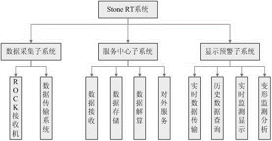
[0021] like image 3 , build the power supply part, if using solar power, connect the solar panel to the solar controller with wires, and at the same time connect the power supply level to the solar controller, lead the wires from the solar controller and use a specific receiver power supply interface to give the receiver The machine can provide continuous power supply. When there is sun, it can charge the battery level, and at night or when there is no sun, it can use the battery level to directly supply power.

[0022] like image 3 , erect the antenna at the point to be monitored, ensure the firmness of the monitoring point, and ensure that the movement of the antenna is consistent with the monitoring point; use a dedicated GNSS signal transmission line to connect the antenna to the GNSS receiver.

[0023] The erection of the reference station, the erection structure of the reference station is basically the same as the structure of the detection point, but for the referen...


PUM


Abstract

The invention relates to a multimode GNSS high-precision real-time deformation monitoring system designed for specially detecting slight deformation of artificial buildings and natural landform. The system can be used for all-weather all-day uninterrupted unattended monitoring, reaches the accuracy of real-time 3 mm and day-observation 1 mm, can be used for automatic intelligent prewarning and broadcasting, includes threes parts including data acquisition, service center as well as display and prewarning, and meanwhile supports various satellite positioning systems such as GPS, Beidou, GLONASS and GALILEO, wherein the data acquisition subsystem is used for data acquisition for satellite signals through a receiver and matched soft hardware, and sends data to the service center through a wired or wireless network transmission manner; the service center subsystem is used for quick data processing for all signals received by the receiver, obtains the real-time position of the receiver through the resolving of a high-precision multimode GNSS system dynamic combined difference positioning model, and stores the original collected data and all the position data in a data base for providing latter inquiry and analysis; and the display and prewarning subsystem accesses the service center, and downloads the real-time data or history data for real-time display or pre-warning analysis.

Description

technical field [0001] The invention relates to a three-dimensional deformation monitoring system which utilizes the global navigation satellite system (GNSS) technology to detect the slight deformation of artificial buildings and natural topography. Background technique [0002] Traditional measurement methods are mainly ground monitoring methods or photogrammetry methods; measurement is limited by line-of-sight, and the selection of monitoring network shapes and points requires high requirements; observation errors will continue to accumulate, and the distribution of observation accuracy at each monitoring station is uneven; work Large volume, complex operation, requiring a lot of manpower and material resources; observation accuracy will also be affected by weather, personnel, etc.; deformation response is slow, and it is necessary to collect data from monitoring points and analyze in-house processing to obtain deformation status and trends ;Periodic operations may lead t...

Claims


Application Information

Patent Timeline
Patent Type & Authority Applications(China)
IPC IPC(8): G01B21/32
Inventor 孙红星许昌
Owner 武汉际上空间科技有限公司
Features
  • R&D
  • Intellectual Property
  • Life Sciences
  • Materials
  • Tech Scout
  • Unparalleled Data Quality
  • Higher Quality Content
  • 60% Fewer Hallucinations
Learn More