
Method for drawing exploratory point planar graph on basis of Excel

A technology of excel and plan, which is applied in the field of drawing prospecting point plans based on Excel, can solve problems such as inability to accurately understand the assumptions and needs of technicians, changes in survey plans that cannot be modified in batches, and work efficiency that cannot meet fast-paced production, etc., to achieve convenient batch production The effect of adjustment and modification, large project use value, fast and efficient error rate

Active Publication Date: 2012-10-10
CHEM IND GEOTECHN ENG
View PDF2 Cites 17 Cited by
  • Summary
  • Abstract
  • Description
  • Claims
  • Application Information

AI Technical Summary

Problems solved by technology

Although this method can also solve the problem of drawing the plan of the exploration points, the work efficiency is low, and it can only be used in the case of few exploration points
However, as the production scale, especially the single survey project, becomes larger and larger, sometimes a survey project has hundreds or even thousands of exploration points, so the work efficiency cannot meet the requirements of the existing fast-paced production
[0005] In addition to the above-mentioned deficiencies, the above two methods also have the following common deficiencies: First, they cannot guarantee that the corresponding drilling types of each exploration point in the "exploration point category table" and "exploration point layout plan" are highly consistent ; The second is that when the survey plan changes, it cannot be modified in batches
[0006] To solve the above-mentioned shortcomings, it is of course best for technicians to use targeted programming, but in fact, most engineers and technicians in this field do not understand programming, and professional programmers do not have a deep understanding of geotechnical engineering knowledge, and often cannot Accurately understand the assumptions and needs of technicians in programming
This is the reason why professional software cannot meet the needs of survey engineering, and engineers and technicians can't get rid of the tedious drawing.

Method used


Image

  • Method for drawing exploratory point planar graph on basis of Excel
  • Method for drawing exploratory point planar graph on basis of Excel
  • Method for drawing exploratory point planar graph on basis of Excel

Examples


Embodiment Construction

[0031] The present invention will be further described below in conjunction with the accompanying drawings and embodiments.

[0032] . Set Excel template file

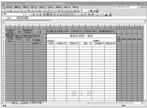
[0033] 1.1 Create a new worksheet

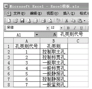
[0034] In the newly-created workbook, create the main worksheet with the worksheet label name "Extrusion Hole Number, Hole Category" and the auxiliary worksheet with the worksheet label name "Hole Category Code".

[0035] The main worksheet includes table header, column number collection area, CAD batch command generation area for expressing blocks and characters of different exploration holes, and hole coordinate input area for exploration holes

[0036] The main worksheet is provided with column number collection area, CAD batch command generation area, hole coordinate input area of ​​exploration holes and various headers. The header includes the header of "List of Exploration Hole Categories" and the header corresponding to the CAD batch command generation area, for example...


PUM


Abstract

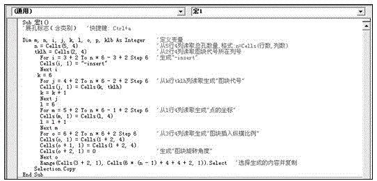
The invention relates to a method for drawing an exploratory point planar graph on the basis of the Excel. The method comprises the following steps of: 1, setting an Excel template file, i.e. setting a corresponding worksheet, wherein the worksheet at least comprises a header, a column number acquisition region, a CAD (Computer Aided Design) batch command generating region for expressing graph blocks and characters of different exploration holes, a hole coordinate input regions of the exploration holes and an element input region; 2, setting a CAD template file, including steps of setting corresponding drawing layers and defining the graph blocks and graph block names as per the elements, and programming a small program of 'numbering and coordinate extracting.dvb'; and 3, by loading the small program of 'numbering and coordinate extracting. dvb', generating a corresponding Excel table, acquiring the coordinates of exploratory points so as to obtain the worksheet, starting a CAD batch command and drawing the exploratory point planar graph. The method has the advantages that the method is simple, is easy to operate, is flexible and changeful, has strong adaptability, is convenient to carry out batch regulation and modification and has large data capacity; the time of generating the exploratory point layout plan in the investigation project is greatly shortened; and the working efficiency is improved.

Description

technical field [0001] The invention relates to geotechnical engineering investigation, in particular to a method for drawing a plan of an exploration point based on Excel. Background technique [0002] In the process of geotechnical engineering investigation, there are basically two ways to draw the "exploration point layout plan" according to the type of exploration points: [0003] One is to use dedicated survey software. Although professional geotechnical engineering survey software has been widely used in geotechnical engineering survey work, the engineering conditions in geotechnical engineering survey vary greatly, and the problems encountered are complex and changeable. These commercial software data processing and The calculation process is opaque, and at the same time, the operability is poor, and adaptive operation cannot be performed according to the change of the situation, resulting in poor flexibility and poor adaptability in use of these software, sometimes ...

Claims


Application Information

Patent Timeline
Patent Type & Authority Applications(China)
IPC IPC(8): G06F17/50
Inventor 尤苏南褚世仙王挺
Owner CHEM IND GEOTECHN ENG
Learn More