Check patentability & draft patents in minutes with Patsnap Eureka AI!

Combined navigation method based on SINS/GPS (strapdown inertial navigation system/global position system)

An integrated navigation and heading angle technology, applied in the field of integrated navigation based on SINS/GPS, can solve the problems of filter divergence, divergence, and inability to obtain navigation parameter estimates

Inactive Publication Date: 2012-12-19
BEIJING INSTITUTE OF TECHNOLOGYGY
View PDF4 Cites 29 Cited by
  • Summary
  • Abstract
  • Description
  • Claims
  • Application Information

AI Technical Summary

Problems solved by technology

However, each nonlinear filtering method has its own limitations, so only relying on filtering techniques cannot obtain accurate navigation parameter estimates under harsh flight conditions
[0004] For inertial navigation systems, the establishment of accurate error equations is the basis for alignment and state error estimation using filtering techniques. If there is an error in the system model, it will affect the filtering accuracy and even cause the filtering to diverge.
The commonly used linear error equations are all derived under the assumption that the misalignment angle of the platform (that is, the attitude error angle) is small. When the misalignment angle is large, the system error presents more serious nonlinear characteristics. These linear equations It is no longer possible to accurately describe the error propagation characteristics of the strapdown inertial navigation system. If it continues to be used, the filtering error may be large or even divergent. Therefore, it is necessary to find a more accurate nonlinear error equation to replace

Method used


Image

  • Combined navigation method based on SINS/GPS (strapdown inertial navigation system/global position system)
  • Combined navigation method based on SINS/GPS (strapdown inertial navigation system/global position system)
  • Combined navigation method based on SINS/GPS (strapdown inertial navigation system/global position system)

Examples


Embodiment Construction

[0090] Below in conjunction with example and accompanying drawing, the present invention is described in further detail.

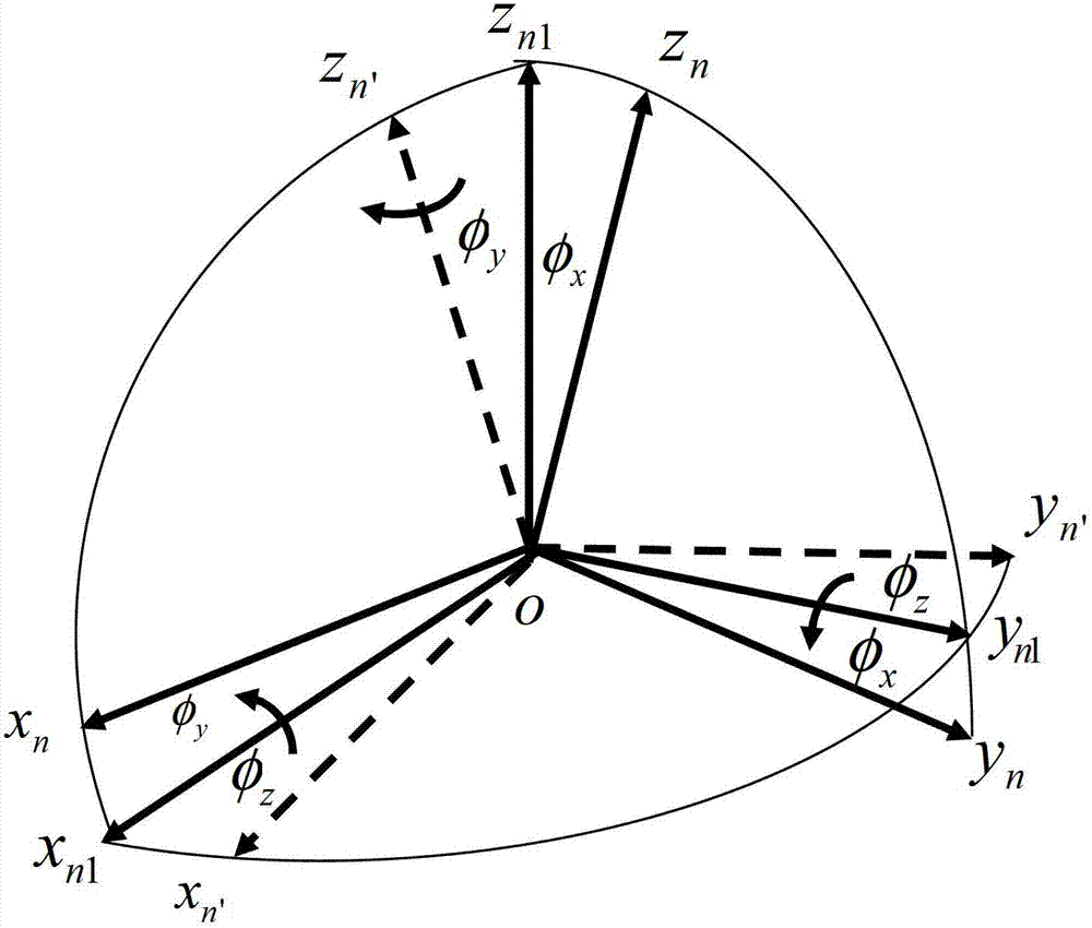
[0091] Coordinates and symbols of this example:

[0092] Coordinate system symbol: ideal navigation coordinate system n, actual navigation coordinate system n′, body coordinate system b Coordinate system selection: select geographic coordinate system (northeast sky) as the navigation coordinate system

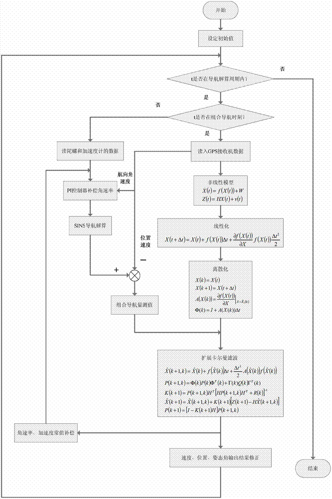
[0093] Step 1: Design a PI (Proportional Integral) controller to compensate the angular rate.

[0094] The attitude matrix of the aircraft (the transformation matrix from the body coordinate system b to the navigation coordinate system n) recorded as

[0095] C b n = C 11 C 12 C ...


PUM


Abstract

The invention relates to a novel combined navigation method based on an SINS (strapdown inertial navigation system) and a GPS (global position system), belongs to a navigation computation module on an unmanned aerial vehicle autopilot instrument in the field of aviation application, and can be applied to various unmanned aerial vehicle unmanned aerial vehicle navigation systems. The combined navigation method comprises the following steps of firstly deducing a nonlinear model of a multi-stage SINS / GPS combined navigation system under the condition that an orientation error angle is a large misalignment angle, and introducing a PI (product improve) controller before SINS resolution to ensure that the angular rate of posture computation carried out at each time is an optimal value at the present. At the moment of SINS / GPS combination, the modification of the angular rate is realized by the following steps of adding the PI controller to carry out exact re-compensation on the angular rate on the basis that an extended Kalman filter algorithm is used for carrying out the certain error compensation on a gyroscope; and at the moment of non-combination, the angular rate value output by the gyroscope still can be modified by the PI controller so that the optimal estimation on combined navigation parameters is obtained.

Description

technical field [0001] The invention relates to a novel combined navigation method of a strapdown inertial navigation system (SINS) and a global positioning system (GPS). This part belongs to the navigation calculation module on the UAV autopilot in the aviation application field, and can be applied to various UAV navigation systems. Background technique [0002] Strapdown Inertial Navigation System (SINS) can provide continuous and real-time navigation information such as position, speed and attitude without any interference from external information. It is a completely autonomous navigation system. However, the shortcoming of navigation errors accumulating over time prevents the SINS from completing long-term high-precision navigation tasks alone, and requires the assistance of other auxiliary systems. The Global Positioning System (GPS) has the advantages of high positioning accuracy and no accumulation of navigation errors over time, but the data update frequency is low...

Claims


Application Information

Patent Timeline
IPC IPC(8): G01S19/49
Inventor 耿庆波李楠李保奎杨淑媛费庆
Owner BEIJING INSTITUTE OF TECHNOLOGYGY
Features
  • R&D
  • Intellectual Property
  • Life Sciences
  • Materials
  • Tech Scout
  • Unparalleled Data Quality
  • Higher Quality Content
  • 60% Fewer Hallucinations
Learn More