Sparse coding and visual saliency-based method for detecting airport through infrared remote sensing image

A remote sensing image and sparse coding technology, which is applied in the field of remote sensing image processing, can solve problems such as false detection and complex background of remote sensing images, and achieve the effect of improving processing speed

Active Publication Date: 2012-12-19
NORTHWESTERN POLYTECHNICAL UNIV
View PDF4 Cites 30 Cited by
  • Summary
  • Abstract
  • Description
  • Claims
  • Application Information

AI Technical Summary

Problems solved by technology

Extract the SIFT local features of the target candidate area for identification, but the background of the remote sensing image is complex, and there are usually signif

Method used


Image

  • Sparse coding and visual saliency-based method for detecting airport through infrared remote sensing image
  • Sparse coding and visual saliency-based method for detecting airport through infrared remote sensing image
  • Sparse coding and visual saliency-based method for detecting airport through infrared remote sensing image

Examples


Embodiment Construction

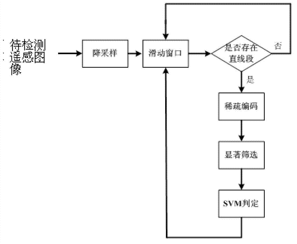
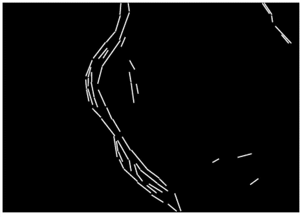
[0030] Now in conjunction with embodiment, accompanying drawing, the present invention will be further described:

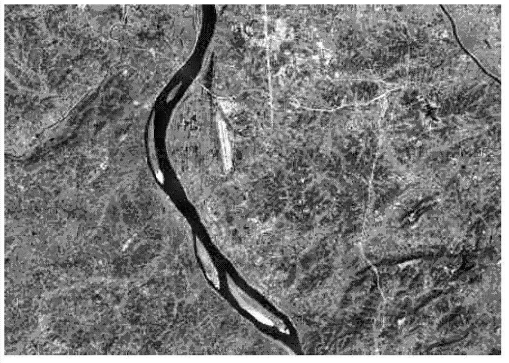
[0031] The hardware environment used for implementation is: Intel Xeon(R) CPU, E5504 2.0G 2.0G (2 processors) computer, 6.0GB internal memory, 1GB graphics card, and the running software environment is: Matlab R2011a, Windows7 64-bit operating system. We have realized the method that the present invention proposes with Matlab software. The infrared remote sensing images used for training and testing in the experiment come from http: / / datamirror.csdb.cn / index.jsp.

[0032] The present invention is specifically implemented as follows:

[0033] 1. Construct a target-background super-complete dictionary: In the original infrared remote sensing image training set, a total of 150 minimum images containing complete airport targets are intercepted, and each image is rotated every 45 degrees, and finally a total of 150*8= 1200 training images of airport objects. The ai...


PUM


Abstract

The invention relates to a sparse coding and visual saliency-based method for detecting an airport through an infrared remote sensing image. The method comprises the following steps of: firstly, down-sampling an original remote sensing image, linearly detecting the down-sampled remote sensing image via using an LSD (Least Significant Difference) algorithm, calculating the saliency of the image via using an FT algorithm; then detecting the airport by utilizing a sliding window target detector, judging whether a linear section exists in the sliding window, if not, sliding the window continuously, if so, carrying out the sparse coding on the window by utilizing a dictionary constructed by an airport target image of the remote sensing image, and screening sparse codes in a way of combining the sparse codes with salient values of the window, so as to obtain sparse expression characteristics of the window; finally, discriminating the sparse code characteristics of the sliding window via an SVM (Support Vector Machine) binary classifier, judging whether the airport exists in the window, and realizing the detection of an airport target ultimately. Compared with other invented technologies, the method has the advantages of high airport detection accuracy and low false alarm rate.

Description

technical field [0001] The invention belongs to the technical field of remote sensing image processing, and in particular relates to a method for detecting airports in infrared remote sensing images based on sparse coding and visual saliency. Background technique [0002] Detecting airport targets from remote sensing images has important practical value for military reconnaissance and precision strikes, and has received more and more attention. In recent years, researchers at home and abroad have tried to solve the airport detection problem by detecting the linear characteristics of the airport runway and analyzing the geometric characteristics of the runway. However, there are a large number of roads, rivers and other interference objects with similar linear characteristics in the remote sensing image. Relying only on linear features will result in a large number of false detections. In addition, the method of image segmentation is used to obtain the candidate area of ​​th...

Claims


Application Information

Patent Timeline
IPC IPC(8): G06K9/00G06K9/66
Inventor 韩军伟姚西文郭雷赵天云程塨钱晓亮
Owner NORTHWESTERN POLYTECHNICAL UNIV
Why Eureka
Try Eureka