Lunar inertial navigation alignment method assisted by star sensor

A technology of star sensors and detectors, which can be used in instruments, integrated navigators, measuring devices, etc., and can solve problems such as low accuracy

Active Publication Date: 2013-01-16
BEIJING INST OF CONTROL ENG
View PDF4 Cites 26 Cited by
  • Summary
  • Abstract
  • Description
  • Claims
  • Application Information

AI Technical Summary

Problems solved by technology

For unmanned lunar probes, this manned method obviously...

Method used


Image

  • Lunar inertial navigation alignment method assisted by star sensor
  • Lunar inertial navigation alignment method assisted by star sensor
  • Lunar inertial navigation alignment method assisted by star sensor

Examples


Embodiment

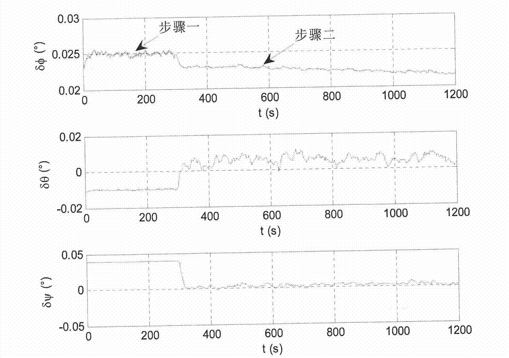
[0149] Here, a simulation example is used to verify the lunar surface take-off and alignment method proposed by the present invention. Assume that the position of the detector on the lunar surface is 45° north latitude, 60° west longitude, and 0m in height, and the longitudinal axis of the detector is upward, but there is a 15° inclination relative to the lunar surface. The detector position given on the ground has an error of 500m (3σ) in longitude, latitude and altitude.

[0150] The probe is equipped with a star sensor and an IMU. Among them, the nominal direction of the optical axis of the star sensor is [cos(38°), cos(54.7°), cos(102.2°)] T , the optical axis error is 3", and the transverse axis error is 24" (3σ); the IMU contains three gyroscopes and three accelerometers, and their input axes point to the same. respectively

[0151] P 1 [cos(54°44′8”), sin(54°44′8”) cos(90°), sin(54°44′8”) sin(90°)] T

[0152] P 2 =[cos(54°44′8”), sin(54°44′8”) cos(210°), sin(54°4...


PUM


Abstract

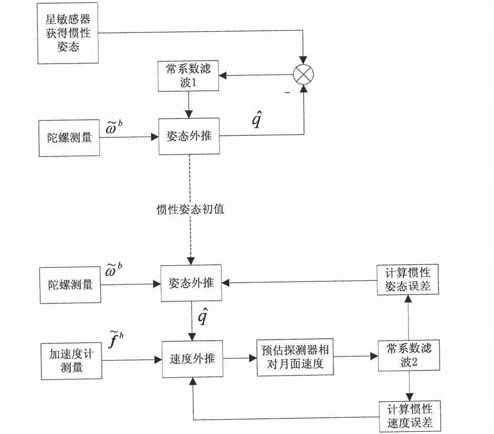
The invention relates to a lunar inertial navigation alignment method assisted by a star sensor, which is suitable for a lunar detector equipped with a strapdown inertial navigation system. The fundamental principle for alignment is that an accelerometer is used to determine the direction of gravity and construct the horizontal plane; and the star sensor is used to measure the inertial attitude so as to determine the azimuth angle in combination with the known position of the take-off point. Accordingly, the lunar inertial navigation alignment method comprises a step of inertial attitude estimation by using the star sensor and a gyroscope, and a step of inertial navigation platform correction of stationary base navigation speed error. The method provided by the invention successfully solves the problem of lunar inertial navigation alignment, and the alignment error is not larger than 0.05 degree.

Description

technical field [0001] The invention relates to an autonomous navigation method for lunar exploration. Background technique [0002] For missions such as lunar sampling and return, after the lunar surface sampling is completed, the lunar probe needs to take off from the lunar surface with lunar soil samples, complete the rendezvous and docking with the orbiting aircraft, and deliver the samples to the orbiting aircraft. Return to Earth. Therefore, the take-off and ascent of the lunar surface is one of the key links for the success of the lunar sampling return mission. The basic means used to take off from the moon or launch a spacecraft is inertial navigation like the earth rocket. Inertial navigation is a recursive navigation method that requires precise initial values, so the alignment of the inertial navigation system must be completed before takeoff. The basic method of inertial navigation alignment on the earth is self-alignment, that is, using the gravity direction ...

Claims


Application Information

Patent Timeline
IPC IPC(8): G01C25/00G01C21/24
Inventor 李骥张晓文王鹏基何英姿张洪华
Owner BEIJING INST OF CONTROL ENG
Why Eureka
Try Eureka