Optimized layout method of water environment quality monitoring stations of river and lake intersected water system

A technology for monitoring site and environmental quality, applied in forecasting, general water supply saving, instruments, etc., to achieve the effect of reducing dependence on experience, avoiding nonlinear data analysis process, eliminating repeated coverage or incomplete coverage

Active Publication Date: 2013-01-30
CHINA THREE GORGES CORPORATION
View PDF1 Cites 22 Cited by
  • Summary
  • Abstract
  • Description
  • Claims
  • Application Information

AI Technical Summary

Problems solved by technology

[0007] The technical problem to be solved by the present invention is to overcome the shortcomings of the existing water environment monitoring network site layout technology, and provide a method for quantitatively optimizing the layout of water environment quality monitoring sites suitable for complex one- and two-dimensional river-lake confluence water systems, which can reduce the need for determination Difficulties in spatial location of water system monitoring stations, improving the representativeness of each monitoring station

Method used


Image

  • Optimized layout method of water environment quality monitoring stations of river and lake intersected water system
  • Optimized layout method of water environment quality monitoring stations of river and lake intersected water system
  • Optimized layout method of water environment quality monitoring stations of river and lake intersected water system

Examples


Embodiment 1

[0044] Example 1 Optimal layout of water environment quality monitoring stations in a local river-lake confluence system in the middle reaches of the Yangtze River

specific Embodiment approach

[0045] In this embodiment, a certain local confluence of rivers and lakes in the middle reaches of the Yangtze River is taken as an example to illustrate the specific implementation of the present invention, specifically as follows:

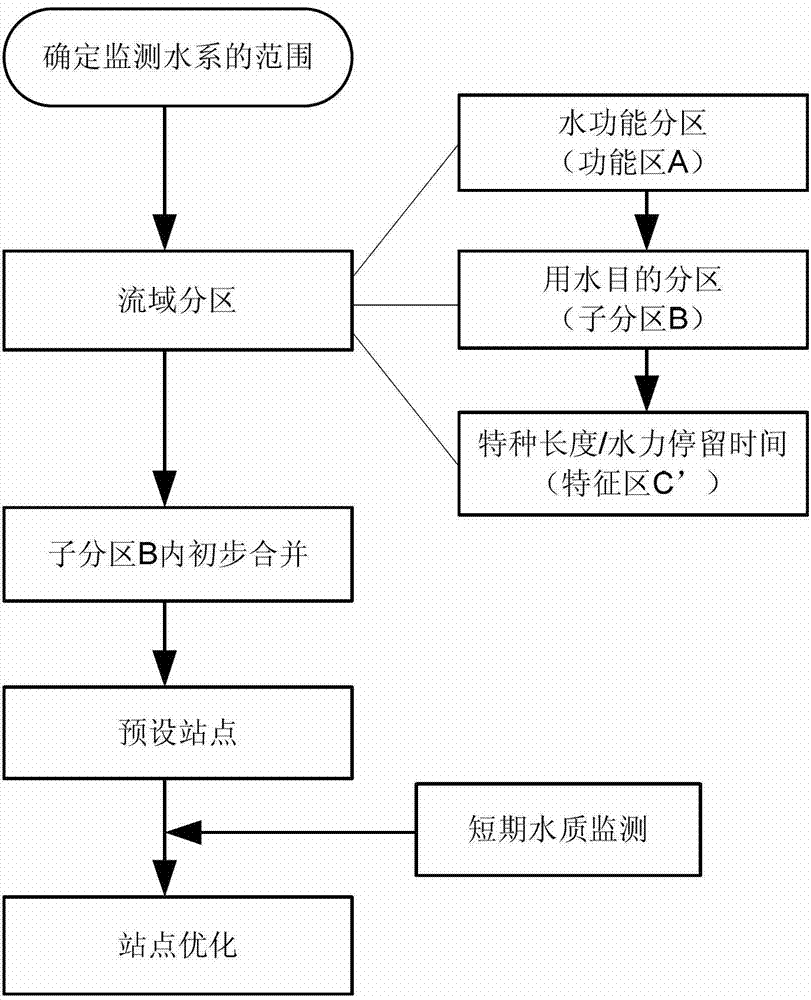
[0046] Step 1: Analyze the flow interaction of all rivers and lakes in the research area according to historical data, and determine the upstream and downstream;

[0047] Step 2: Carry out the first water function zoning of the research water system according to the "Water Functional Zoning Standard" (GB / T 50594), and obtain the water function zoning set A, which belongs to drinking water source area, industrial water area, agricultural water area;

[0048] Step 3: Carry out the second partition on the partition set A, as shown in Table 1, to obtain sub-partition B, which is urban drinking water source area, non-urban drinking water source area, industrial water consumption area, non-industrial water consumption area, Organic agricultural water ...


PUM


Abstract

The invention discloses an optimized layout method of water environment quality monitoring stations of a river and lake intersected water system. According to the invention, a complicated intersected water system is divided into three levels, namely, a water function division A, a characteristic subarea B and a characteristic area C with various water quality conditions, a multi-objective problem is decomposed into the problem of optimization of a plurality of single objects; and by providing quantitative optimization standard and calculation method, dependence on personal experience is reduced, ambiguity and incompatibility caused by complicated geographical environment factors are avoided, and comprehensive and objective monitoring on the water environment quality of the area can be realized with lowest investment.

Description

technical field [0001] The invention belongs to the technical field of environmental protection, and relates to an optimal layout method of water environment monitoring points, and more particularly, to an optimal layout method of water environment quality monitoring network sites suitable for complex water systems where rivers and lakes meet. Background technique [0002] The basic forms of inland water systems are generally divided into two types: rivers and lakes (reservoirs), but when these two types of water bodies meet and connect with each other, a unique river and lake confluence water system will be formed. The confluence water system of rivers and lakes has the composite characteristics of both one-dimensional rivers and two-dimensional water surfaces. For example, in the middle reaches of the Yangtze River in China, the narrow and long Yangtze River meets the broad Poyang Lake and Dongting Lake. The geographical shape is very complicated and cannot be simply classi...

Claims


Application Information

Patent Timeline
Patent Type & Authority Applications(China)
IPC IPC(8): G06Q10/04G06Q50/26
CPCY02A20/152
Inventor 戴会超毛劲乔李智张末
Owner CHINA THREE GORGES CORPORATION
Why Eureka
Try Eureka