Automatic geometric correction and orthorectification method for multispectral remote sensing satellite images of mountainous area

A technology of orthorectification and geometric correction, which is applied in the direction of instruments, character and pattern recognition, computer parts, etc., can solve the problems of inaccurate correction of image distortion and large geometric distortion

Active Publication Date: 2013-03-13
INST OF MOUNTAIN HAZARDS & ENVIRONMENT CHINESE ACADEMY OF SCI
View PDF3 Cites 33 Cited by
  • Summary
  • Abstract
  • Description
  • Claims
  • Application Information

AI Technical Summary

Problems solved by technology

Therefore, using traditional algorithm principles to carry out geometric correction and orthorectification of mountainous side-view multispectral remote sensing satellite images with large geometric distortions and complex causes, such as multispectral remote sensing satellite images captured by China's domestic environmental disaster reduction satellite, cannot be corrected accurately Distortion in imagery, especially geometric distortion caused by terrain

Method used


Image

  • Automatic geometric correction and orthorectification method for multispectral remote sensing satellite images of mountainous area
  • Automatic geometric correction and orthorectification method for multispectral remote sensing satellite images of mountainous area
  • Automatic geometric correction and orthorectification method for multispectral remote sensing satellite images of mountainous area

Examples


Embodiment Construction

[0047] Below in conjunction with accompanying drawing and specific embodiment, the present invention is further described in detail:

[0048] The present invention will be specifically described below by taking the processing of images of China's domestic environmental disaster reduction satellite (model: HJ-1A / B) as an example:

[0049] like Figure 5 As shown, the method of the present invention comprises the following steps:

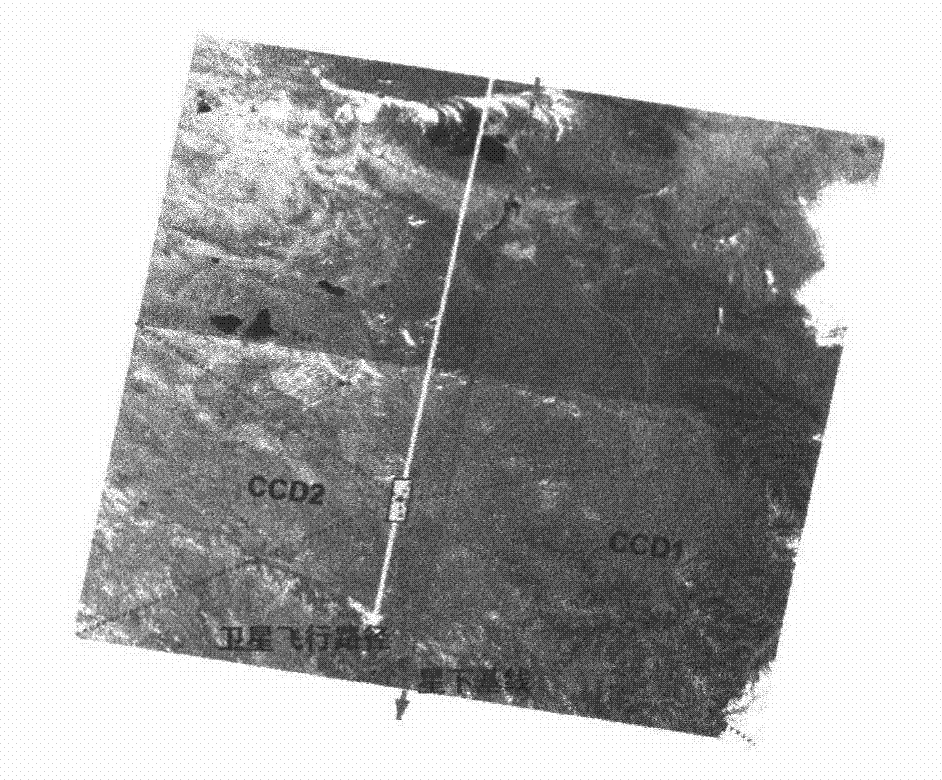
[0050] (1) Selection and splicing of reference images: a. Selection of reference images: The reference images meet the following conditions: the overall cloud coverage is less than 5%; the registration error of images on different platforms and the edges of adjacent images is less than 0.5 pixels; b . Splicing of reference images: splicing the near-infrared bands of reference images.

[0051] The reasons for satisfying the above two conditions are as follows: the selection of the reference image is the key to determine the precise geometric correcti...


PUM


Abstract

The invention discloses an automatic geometric correction and orthorectification method for multispectral remote sensing satellite images of a mountainous area. The method comprises the following steps of: selection and splicing of reference images; automatic selection of object points with same names; screening of the object points with same names, and geometric correction and orthorectification for correcting the images; precision evaluation; and output of the images. The multispectral remote sensing satellite images of the mountainous area, such as images of China domestic environment and disaster monitoring small satellite (with the model HJ-1A/B), have the characteristic of serious geometric distortion, but the automatic geometric correction and orthorectification method can be used for performing the orthorectification on the multispectral remote sensing satellite images of the mountainous area in mass and generating residual error reports of the coherent images by adopting a concept of the object points with same names to implement the geometric correction and orthorectification. The automatic geometric correction and orthorectification method has the advantages of high efficiency and precision, is very efficient when being used for processing the multispectral remote sensing satellite images with mass data of the mountainous area, can remarkably save manpower and material resources needed by the conventional remote sensing image processing process, and particularly is beneficial to the processing of the images of the China domestic environment and disaster monitoring small satellite.

Description

technical field [0001] The invention relates to a method for geometric correction and orthorectification of multi-spectral remote sensing satellite images in mountainous areas, in particular to an automatic geometric correction and orthorectification method for multi-spectral remote sensing satellite images in mountainous areas required in the aerospace field, belonging to the multi-spectral area in mountainous areas. The field of computer processing of remote sensing satellite images. Background technique [0002] The geometric correction and orthorectification of remote sensing satellite images are the basic work of remote sensing image preprocessing, and also a key step in the later application of remote sensing satellite images to carry out aspects such as ecological environment monitoring, disaster monitoring and assessment. In practical applications, the geometric distortion of remote sensing satellite images is relatively serious. figure 1 It shows the principle of g...

Claims


Application Information

Patent Timeline
Patent Type & Authority Applications(China)
IPC IPC(8): G06K9/32
Inventor 李爱农边金虎蒋锦刚雷光斌
Owner INST OF MOUNTAIN HAZARDS & ENVIRONMENT CHINESE ACADEMY OF SCI
Why Eureka
Try Eureka