Visual mining method for vehicle GPS (global positioning system) data analysis and abnormality monitoring

A GPS data and anomaly monitoring technology, applied in the direction of electrical digital data processing, special data processing applications, instruments, etc., can solve the problems of time-consuming and resource-consuming, achieve good scalability and improve analysis efficiency

Active Publication Date: 2013-04-03
GUANGZHOU HKUST FOK YING TUNG RES INST
View PDF3 Cites 32 Cited by
  • Summary
  • Abstract
  • Description
  • Claims
  • Application Information

AI Technical Summary

Problems solved by technology

In the case of exceptions, users will need to spend more time and resources to make decisions

Method used


Image

  • Visual mining method for vehicle GPS (global positioning system) data analysis and abnormality monitoring
  • Visual mining method for vehicle GPS (global positioning system) data analysis and abnormality monitoring
  • Visual mining method for vehicle GPS (global positioning system) data analysis and abnormality monitoring

Examples


Embodiment Construction

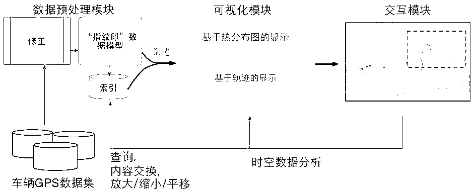
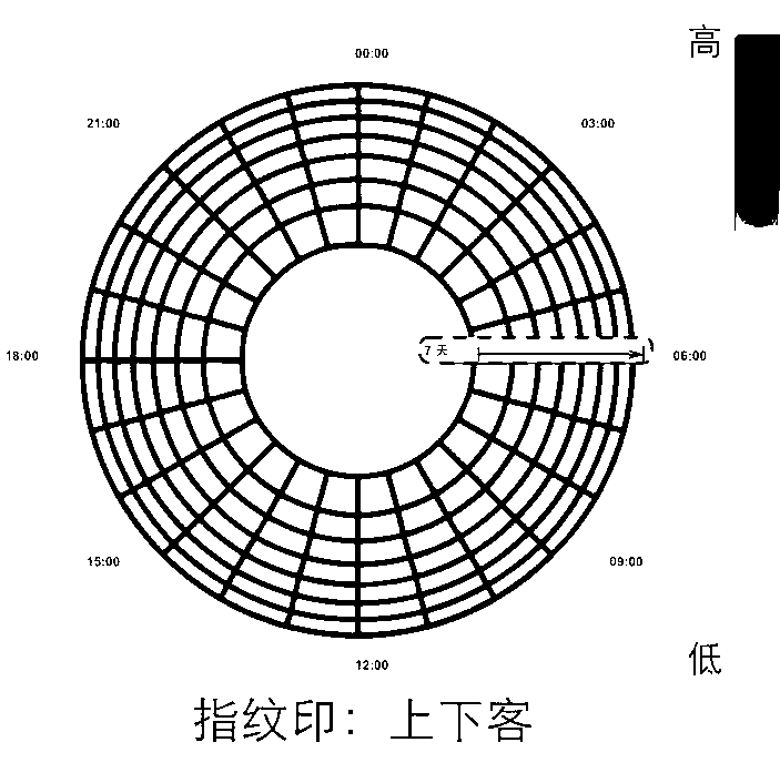
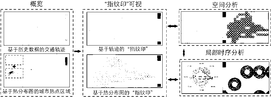
[0029] Such as figure 1 As shown, the data conversion module defines the visual data structure "fingerprint" and the corresponding interface used in vehicle GPS data analysis and abnormal monitoring, and also provides the necessary I / O operation interface. And read the original GPS data in the network stream, and convert it into abstract structures such as tables, graphs, and trees. The visualization module contains two parts, visualization data processing and layout processing. Visual data processing will add corresponding geometric information fields from the abstract data elements defined in the data conversion module to maintain the size, position and other information of visual elements; layout processing uses layout algorithms to generate geometric information and set it to the visual data Geometry domain. Such as figure 1 The illustrated invention provides two different types of layout algorithms to users, density-based urban heat map detection and historical data-ba...


PUM


Abstract

The invention relates to a visual mining method based on a visualization technology for vehicle GPS (global positioning system) data analysis and abnormality monitoring. Original vehicle GPS data are converted by a data conversion module into a unique visual ''fingerprint stamp'' data model, a data index for real-time response to user interaction is provided to help a user to analyze data; and a visual vehicle data model is combined with a display based on a heat distribution map and a trajectory through a visualization module, detection of urban hot spot areas and traffic trajectory abnormality monitoring based on historical data are performed, and certain abstract concepts in the data, such as frequent rules and periodic rules, are displayed in an easy-to-understand way for an analyzer. The analysis threshold can be lowered, the scope of application can be expanded, and the analysis efficiency can be improved. Rich interaction operations can be realized through a user interaction module, monitoring and analysis can be performed by the user, and analysis and support can be provided for decisions of the user.

Description

technical field [0001] The invention relates to a method for realizing vehicle GPS data analysis and abnormal monitoring by using visualization technology. This method can support streaming data to be displayed and monitored in real time, and use the visual data model "fingerprint" to integrate some abstract concepts in vehicle GPS data, such as frequent law and periodic law, in a way that analysts can easily understand To display, lower the threshold of analysis, expand the scope of application, and improve the efficiency of analysis. Background technique [0002] After more than 20 years of practice, the GPS system is a high-precision, all-weather and global multi-functional system for radio navigation, positioning and timing. GPS related systems are widely used in public security, medical care, fire protection, transportation, logistics and other fields. In recent years, GPS devices, mobile communication devices, and various sensor devices have been widely used around t...

Claims


Application Information

Patent Timeline
Patent Type & Authority Applications(China)
IPC IPC(8): G06F17/30
Inventor 蒲剑苏屈华民倪明选
Owner GUANGZHOU HKUST FOK YING TUNG RES INST
Why Eureka
Try Eureka