
Interval type-2 fuzzy geographic area topological relation determining method based on IT2 FS (interval type-2 fuzzy set)

A technology of topological relationship and fuzzy area, applied in image data processing, electrical digital data processing, special data processing applications, etc., can solve the problems of a large number of topological relationships, fuzzy membership errors, and inability to make good use of data resources. , to achieve the effect of improving accuracy and reliability, and improving utilization

Inactive Publication Date: 2013-04-10
TIANJIN NORMAL UNIVERSITY
View PDF1 Cites 6 Cited by
  • Summary
  • Abstract
  • Description
  • Claims
  • Application Information

AI Technical Summary

Problems solved by technology

This method still has a problem in the calculation that it can only use data of one scale, such as the remote sensing data of the first phase to extract fuzzy geographical phenomena, which cannot make good use of data resources, and cannot represent the fuzzy membership degree of any position inside the fuzzy area. error
The second problem is that the number of topological relationships generated by this method is too large. It is difficult for people to remember these topological relationships one by one, and it is also difficult to find appropriate vocabulary to express these topological relationships in life. In fact, what people need to judge is What is the topological relationship between the two objects, and the degree of belonging to this relationship

Method used


Image

  • Interval type-2 fuzzy geographic area topological relation determining method based on IT2 FS (interval type-2 fuzzy set)
  • Interval type-2 fuzzy geographic area topological relation determining method based on IT2 FS (interval type-2 fuzzy set)
  • Interval type-2 fuzzy geographic area topological relation determining method based on IT2 FS (interval type-2 fuzzy set)

Examples


Embodiment Construction

[0030] The present invention will be described in detail below with reference to the drawings and examples.

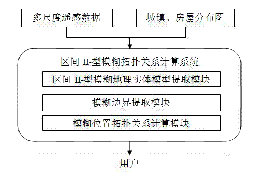
[0031] Remote sensing data of multiple scales, towns, houses, land use and other thematic data are used as input data. The fuzzy distribution range of fuzzy geographic phenomena is extracted from multi-scale remote sensing data, the interval II-type fuzzy geographic object model is established, and then the boundary model is extracted. Then, the fuzzy position topological relationship calculation module is used to determine the topological relationship between two objects and the degree of this topological relationship. The method for determining the topological relationship of interval II-type fuzzy regions is realized. Detailed process such as figure 1 shown.

[0032] 1. Interval II-type fuzzy geographic area model extraction module

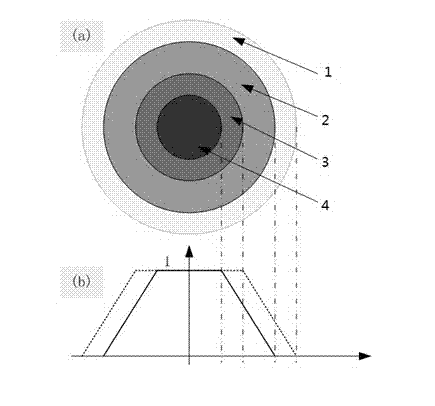
[0033] Firstly, the conventional fuzzy classification method is used to extract the distribution range of fuzzy geographical pheno...


PUM


Abstract

The invention discloses an interval type-2 fuzzy geographic area topological relation determining method based on an IT2 FS (interval type-2 fuzzy set). A topological relation analysis system is constructed by adopting multi-scale remotely sensed data and a fuzzy geographic entity model. The distribution range of fuzzy geographic targets is extracted from the multi-scale remotely sensed data. However, the distribution range cannot be accurately defined and can only be expressed by adopting a fuzzy method. An interval type-2 fuzzy mathematical model is used for expressing the possible distribution range of the geographic targets. An interval type-2 fuzzy topological relation computing system consists of an interval type-2 fuzzy geographic area extraction module, an interval type-2 fuzzy boundary extraction module and an interval type-2 fuzzy position topological relation computing module. The multi-scale remotely sensed data enters the system, the fuzzy distribution range is extracted and the boundary area of the distribution range is extracted. The interval type-2 fuzzy position topological relation computing module conducts analysis by using the fuzzy distribution range, the boundary area and data such as houses and towns to obtain a fuzzy analysis result, so as to realize the computation of the fuzzy position topological relation.

Description

[0001] This application was supported by the National Natural Science Foundation of China (41101352); Tianjin Normal University Doctoral Fund (52XB1008). technical field [0002] The present invention relates to a method for determining the topological relationship between fuzzy regions in geographic information science and image analysis, more specifically, to a method for extracting the fuzzy region range of forests from remote sensing data, or the fuzzy range of disaster areas such as mudslides and sandstorms, Deterministic methods for determining whether a house, town, or town lies within these ambiguous areas. Background technique [0003] At present, the method of determining the topological relationship between fuzzy regions adopts geometric entity judgment or conventional fuzzy object model analysis. [0004] The geometric entity judgment method uses conventional geometric surfaces to represent fuzzy phenomena, such as using a polygon to represent disaster areas suc...

Claims


Application Information

Patent Timeline
IPC IPC(8): G06F17/30G06T7/00
Inventor 郭继发崔铁军
Owner TIANJIN NORMAL UNIVERSITY
Learn More