Secondary clustering segmentation method for satellite cloud picture

A satellite cloud image and secondary clustering technology, which is applied in the field of processing meteorological satellite cloud images, can solve problems such as noise resistance, unsatisfactory segmentation accuracy, and unfavorable practical applications.

Inactive Publication Date: 2013-04-10
NINGBO UNIV
View PDF3 Cites 34 Cited by
  • Summary
  • Abstract
  • Description
  • Claims
  • Application Information

AI Technical Summary

Problems solved by technology

However, most of the existing methods are only suitable for classification of cloud images with a small range and few categories, and most of the methods a

Method used


Image

  • Secondary clustering segmentation method for satellite cloud picture
  • Secondary clustering segmentation method for satellite cloud picture
  • Secondary clustering segmentation method for satellite cloud picture

Examples


Embodiment

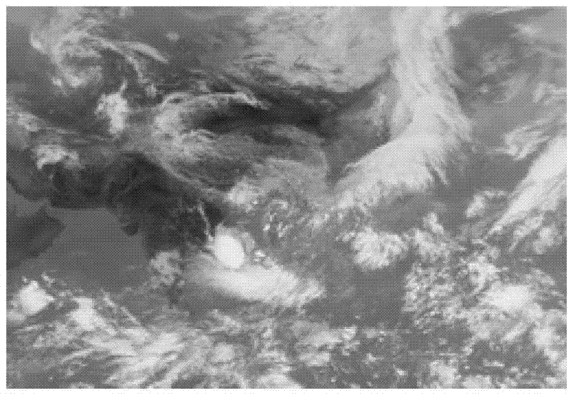
[0084] Embodiment: In this embodiment, the FY2-D satellite provided by China National Satellite Meteorological Center is used to collect the IR1 (infrared one channel) channel partition map at 5:30 am on May 29, 2012, supplemented by IR2 (infrared two channel ), IR3 (infrared three-channel), water vapor and VIS four-channel partition map for experiments. According to the algorithm of the present invention, secondary clustering and segmentation are performed on the IR1 channel satellite cloud image.

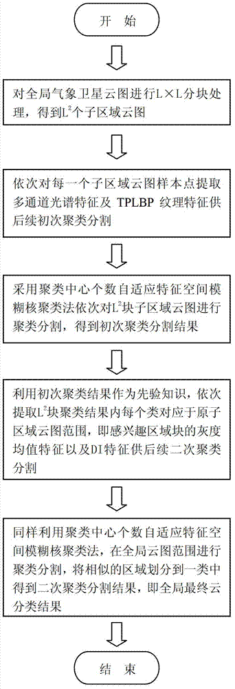
[0085] A method for secondary clustering and segmentation of satellite cloud images, comprising the following steps:

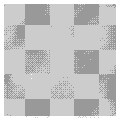
[0086] ① For example Figure 2a The satellite cloud image shown is divided into blocks, and the satellite cloud image is divided into L×L total L 2 Sub-area nephogram with equal block size; such as Figure 2b As shown, in this embodiment, the large-scale satellite cloud image is divided into 3 × 3, a total of 9 equal-sized sub-area cloud images for subsequent i...


PUM


Abstract

The invention discloses a secondary clustering segmentation method for a satellite cloud picture. According to the secondary clustering segmentation method for the satellite cloud picture, firstly, block processing is carried out to the whole wide-range satellite could picture; secondly, corresponding multi-channel spectral features and three-patch length between perpendiculars (TPLBP) textural features are sequentially extracted from each of sample points of each sub regional could picture for fine initial kernel clustering segmentation so as to obtain multiple sub regional could picture segmentation results; and at last, secondary kernel clustering segmentation is carried out to the global cloud picture on the basis of the initial kernel clustering segmentation results by utilization of the initial kernel clustering segmentation results as prior knowledge to extract a variety of grayscale average features and density indicator features of the initial kernel clustering segmentation results in a corresponding original sub regional cloud picture range so as to ensure integrity of cloud classification. The secondary clustering segmentation method for the satellite cloud picture has the advantages of being high in precision and robustness, and capable of identifying cloud classification in a fine mode according to huge and complicated geographical information, ocean information, atmospheric information and other information which are contained in the wide-range meteorological satellite cloud picture.

Description

technical field [0001] The invention relates to a processing technology of meteorological satellite cloud images, in particular to a method for secondary clustering and segmentation of satellite cloud images. Background technique [0002] Weather forecasting is an important application in meteorology, which is closely related to everyone's daily life, even related to the safety of people's lives and property. Accurate cloud classification is the basis of weather forecast, so it is very important to segment satellite cloud images to achieve correct cloud classification. The earliest cloud image classification was analyzed and judged by meteorologists with naked eyes through rich meteorological knowledge. However, with the development of meteorological satellite technology, large-scale meteorological satellites send cloud image data of more than GB order to the ground every day. Taking my country's Fengyun-2 D satellite (FY2-D) as an example, its launch in December 2006 succe...

Claims


Application Information

Patent Timeline
IPC IPC(8): G06K9/46G06K9/62
Inventor 金炜范亚会符冉迪励金祥李纲
Owner NINGBO UNIV
Why Eureka
Try Eureka