Real-time spatial positioning method for mobile monitoring target in geographical scene

A technology for monitoring targets and scenes, applied in the fields of video surveillance and geographic information, which can solve the problems that it is difficult for staff to judge and track the real-time position of moving targets, lack of ground reference objects, etc.

Inactive Publication Date: 2013-07-31
FUZHOU SILVISCENE INFORMATION TECH CO LTD
View PDF1 Cites 82 Cited by
  • Summary
  • Abstract
  • Description
  • Claims
  • Application Information

AI Technical Summary

Problems solved by technology

However, in a large-scale and complex natural geographical environment, due to factors such as the continuous rotation of the surveillance camera and

Method used


Image

  • Real-time spatial positioning method for mobile monitoring target in geographical scene
  • Real-time spatial positioning method for mobile monitoring target in geographical scene
  • Real-time spatial positioning method for mobile monitoring target in geographical scene

Examples


Embodiment Construction

[0048] The present invention will be further described below in conjunction with the accompanying drawings and embodiments.

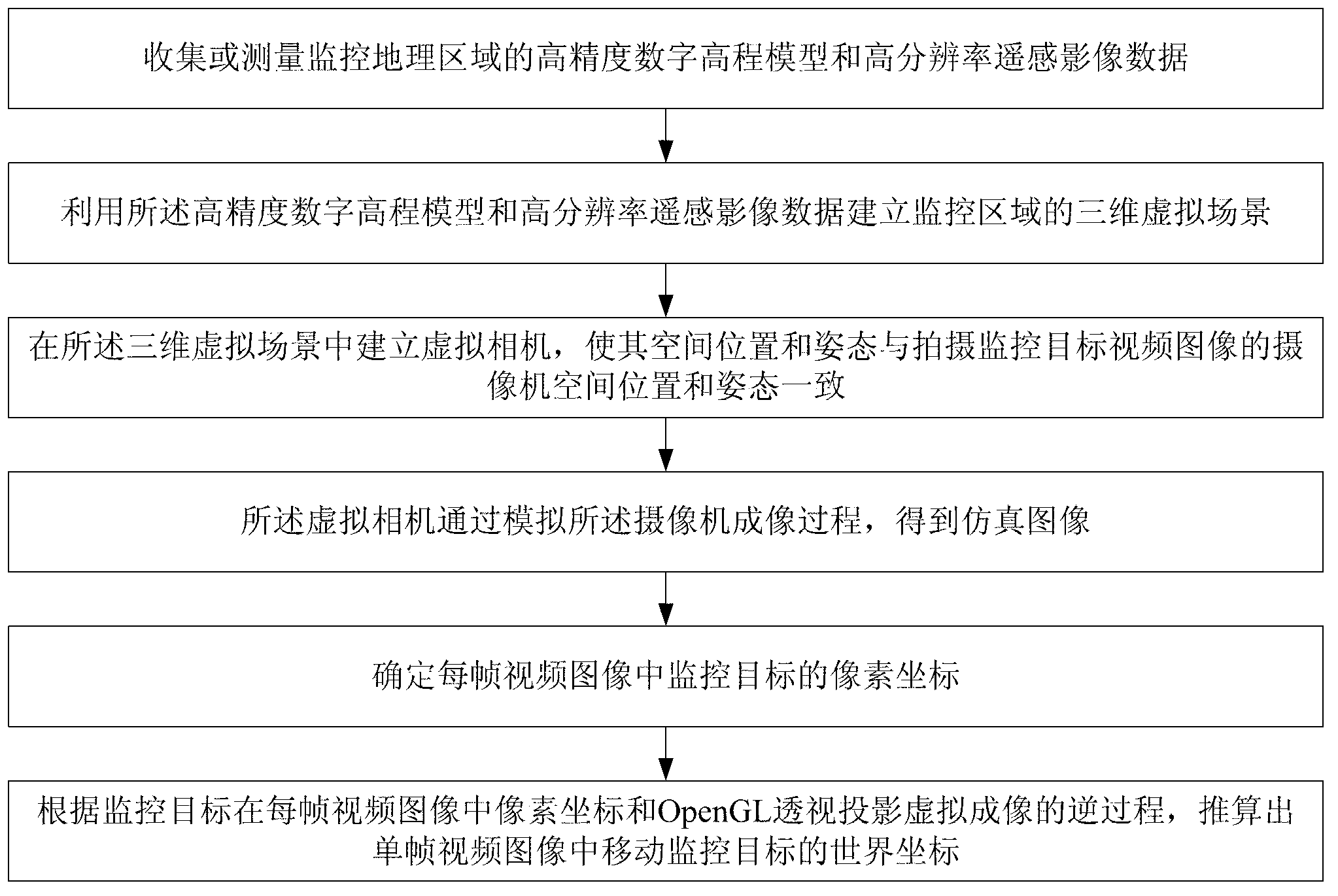
[0049] figure 1 A method for real-time spatial positioning of a mobile monitoring target in a geographical scene of the present invention is shown, comprising the following steps:

[0050] Collect or measure high-precision digital elevation models and high-resolution remote sensing image data of monitored geographical areas;

[0051] Using the high-precision digital elevation model and high-resolution remote sensing image data to establish a three-dimensional virtual scene of the monitoring area;

[0052] Set up virtual camera (can set up virtual camera by setting OpenGL imaging function, these imaging functions include projection matrix, observation matrix and viewport matrix) in described three-dimensional virtual scene, make its spatial position and posture and the video camera of shooting monitoring target video image The spatial position and atti...


PUM


Abstract

The invention discloses a real-time spatial positioning method for a mobile monitoring target in a geographical scene, which aims at solving the problems of great difficulty, time consumption and the like due to the fact that spatial positioning of a target in a video monitoring system requires artificial interpretation. The method comprises the steps of adopting a three-dimensional scene modeling technology, constructing a three-dimensional virtual geographical scene virtual imaging and a target spatial positioning computing system, rendering the existing high-precision digital elevation model or a three-dimensional scene model of a monitoring area, generating a three-dimensional virtual scene, setting parameters such as positions, postures and focal distances of cameras in a shooting process of each video image as virtual camera parameters in the scene according to a consistency relation between OpenGL (Open Graphics Library) perspective imaging and a photogrammetric principle, generating a simulated image, and reversely deducing three-dimensional geographic coordinates of the target according to consistency of the video image and the simulated image, and a reverse process of the perspective imaging. According to the real-time spatial positioning method, the quick positioning of a field mobile target can be achieved by utilizing a video monitoring image in a wide-range geographic environment.

Description

technical field [0001] The invention relates to the fields of video surveillance and geographic information technology. Compared with traditional video surveillance that simply obtains real-time video information of monitoring targets, the video surveillance system combined with geographic information technology can not only give full play to the advantages of real-time image visualization of the video surveillance system, but also give full play to the characteristics of geographic information technology, and timely feedback monitoring The spatial location information of the target improves the efficiency of security prevention work. The invention provides a method for real-time spatial positioning of a mobile monitoring target in a geographical scene. The method is suitable for target spatial positioning in an outdoor large-scale video monitoring system, reduces the workload of manual positioning, and improves the quality of video monitoring engineering applications. techn...

Claims


Application Information

Patent Timeline
IPC IPC(8): G06T15/00
Inventor 王熠中李界光杜云虎刘先锋
Owner FUZHOU SILVISCENE INFORMATION TECH CO LTD
Why Eureka
Try Eureka