Polarimetric synthetic aperture radar interferometry (POLInSAR) vegetation height inversion method based on complex field adjustment theory

A technology of adjustment theory and height inversion, applied in the field of POLInSAR vegetation height inversion, which can solve problems such as difficult to represent topographic maps

Active Publication Date: 2013-08-07
CENT SOUTH UNIV
View PDF2 Cites 28 Cited by
  • Summary
  • Abstract
  • Description
  • Claims
  • Application Information

AI Technical Summary

Problems solved by technology

Due to the influence of vegetation height in forested areas, topographic maps surveyed and mappe

Method used


Image

  • Polarimetric synthetic aperture radar interferometry (POLInSAR) vegetation height inversion method based on complex field adjustment theory
  • Polarimetric synthetic aperture radar interferometry (POLInSAR) vegetation height inversion method based on complex field adjustment theory
  • Polarimetric synthetic aperture radar interferometry (POLInSAR) vegetation height inversion method based on complex field adjustment theory

Examples


Embodiment Construction

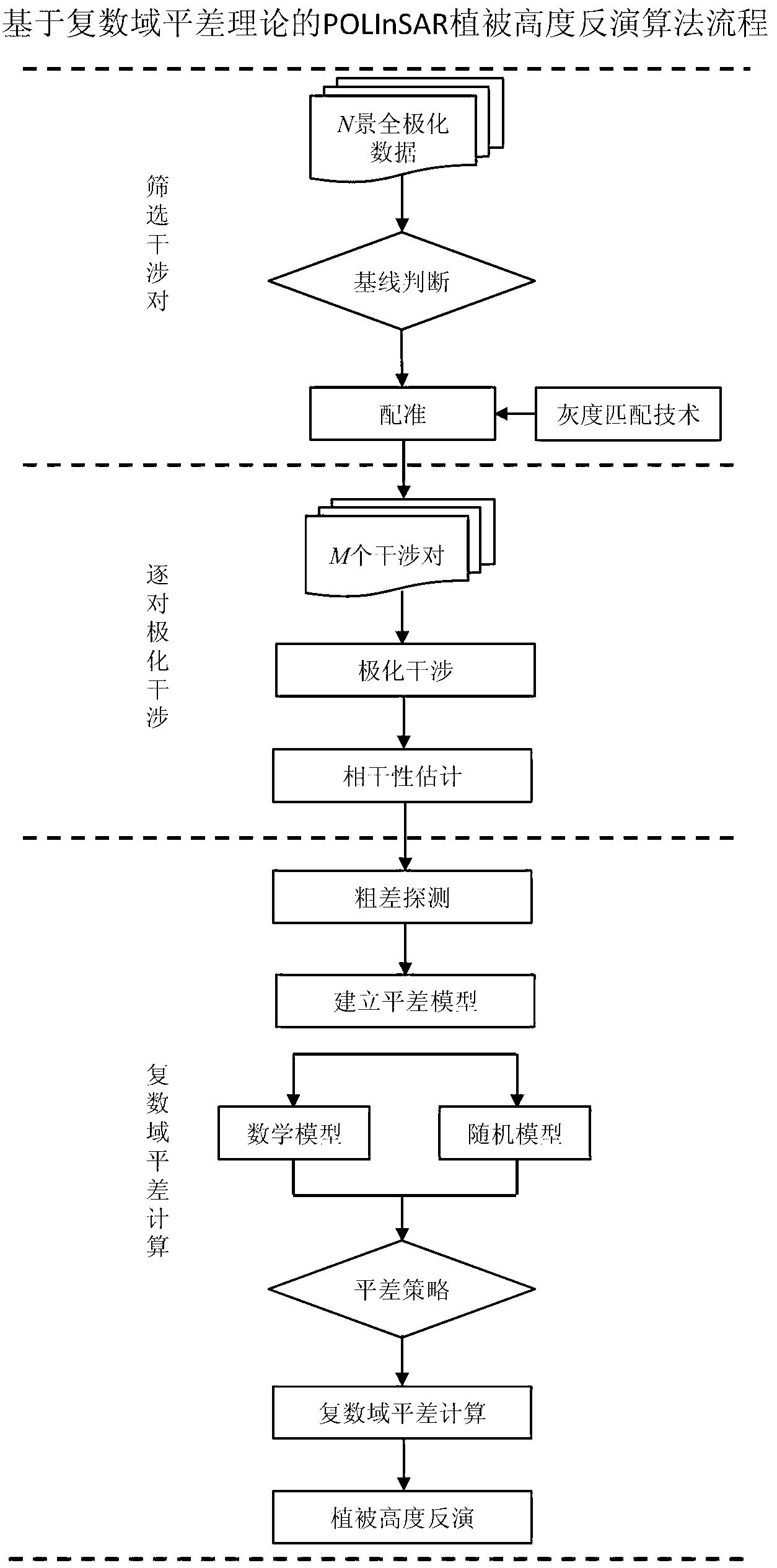
[0090] In order to make the purpose, technical solution and advantages of the present invention clearer, the present invention is further described in detail using the 2-view full polarization data simulated by the POLSARpro software released by the European Space Agency (see attached table 1 for simulation parameter settings). It should be understood that the specific embodiments described here are only used to explain the present invention, not to limit the present invention.

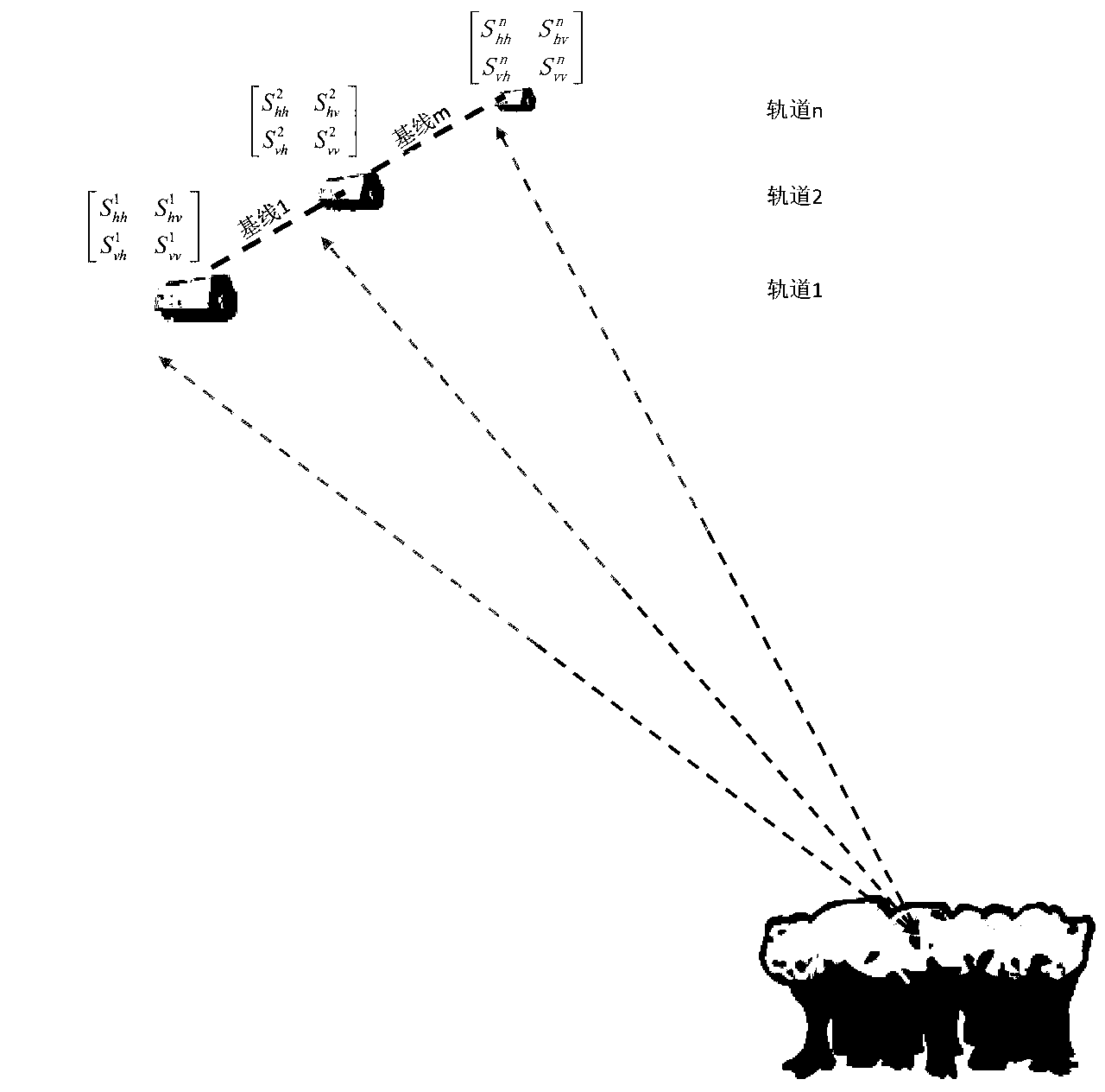
[0091] The specific embodiment of the present invention is described with a single-baseline line observation configuration, that is, a situation where there are only two full-polarization SAR images in the imaging area. Corresponding to each full polarization SAR image, the polarization scattering matrix (S matrix) is used to express the image data of these four channels as shown in formula (1). In this formula, S pq Indicates the backscattering of the target when q polarization is transmitted and p ...


PUM


Abstract

The invention relates to application of microwave remote sensing in the field of forests and discloses a polarimetric synthetic aperture radar interferometry (POLInSAR) vegetation height inversion method based on complex field adjustment theory. The complex field adjustment theory and a physical model for POLInSAR vegetation height inversion are organically combined by the method. The method comprises the following steps of: I, performing registration on obtained complete polarization data of N scenes to obtain M baseline interference pairs; II, performing polarized interference on the M baseline interference pair to obtain M*P interference fringe patterns, and estimating corresponding complex coherences of the M*P interference fringe patterns; and III, working out a vegetation height hv based on complex field adjustment computation. The POLInSAR vegetation height inversion method based on the complex field adjustment theory is visual in principle, is easy to realize programming and extension, is a steady and feasible vegetation height inversion method, and can be widely applied to the POLInSAR technology to measure the vegetation height within a large-scale area and even a global scale.

Description

technical field [0001] The invention relates to the application of microwave remote sensing in the field of forests, in particular to a POLInSAR vegetation height inversion method based on complex domain adjustment theory. Background technique [0002] Topographic maps are indispensable basic maps for national economic construction, social development and national security, and basic data necessary for infrastructure planning, design and construction, as well as resource investigation and development. Due to the influence of vegetation height in forested areas, topographic maps surveyed and mapped by traditional remote sensing methods are often difficult to represent the real topographic map. Therefore, how to obtain vegetation height quickly and accurately is very important for obtaining a high-precision digital terrain model. In addition, vegetation height, as one of the main parameters of forest canopy structure, affects the dynamics and composition of plant communities ...

Claims


Application Information

Patent Timeline
IPC IPC(8): G01S7/48
Inventor 朱建军解清华付海强李志伟汪长城
Owner CENT SOUTH UNIV
Why Eureka
Try Eureka