
Multiscale DEM (Digital Elevation Model) modeling method giving consideration to contents of surface hydrology

A modeling method and context technology, applied in the field of multi-scale DEM modeling considering the context of surface hydrology, can solve problems such as lack of algorithmic models, achieve the effect of improving automation and generation efficiency, and ensuring topology and logic consistency

Inactive Publication Date: 2013-08-07
WUHAN UNIV
View PDF1 Cites 36 Cited by
  • Summary
  • Abstract
  • Description
  • Claims
  • Application Information

AI Technical Summary

Problems solved by technology

In the process of DEM synthesis, there is still no applicable algorithm model for how to correlate the spatial context for consistent simplification

Method used


Image

  • Multiscale DEM (Digital Elevation Model) modeling method giving consideration to contents of surface hydrology
  • Multiscale DEM (Digital Elevation Model) modeling method giving consideration to contents of surface hydrology
  • Multiscale DEM (Digital Elevation Model) modeling method giving consideration to contents of surface hydrology

Examples


Embodiment

[0062] One, at first, introduce the theoretical knowledge that the present invention relates to.

[0063] 1. Theoretical basis.

[0064] DEM data synthesis, derived from a larger scale (high resolution) DEM to a smaller scale (low resolution) DEM, is to summarize and simplify terrain information, rather than simply discarding detailed features. Therefore, although DEM synthesis is usually expressed as data compression at the operational level, at the operational decision-making level, the terrain features contained in DEM should be used as the geographical basis, and it should be associated with the data model as the spatial context of the comprehensive behavior. Collaborative simplification. As far as geomorphological elements are concerned, topographic relief reflects that mature valleys and ridges have obvious water collection and water separation characteristics. This is not only the theoretical basis for surface hydrological analysis and hydrological element extraction i...


PUM


Abstract

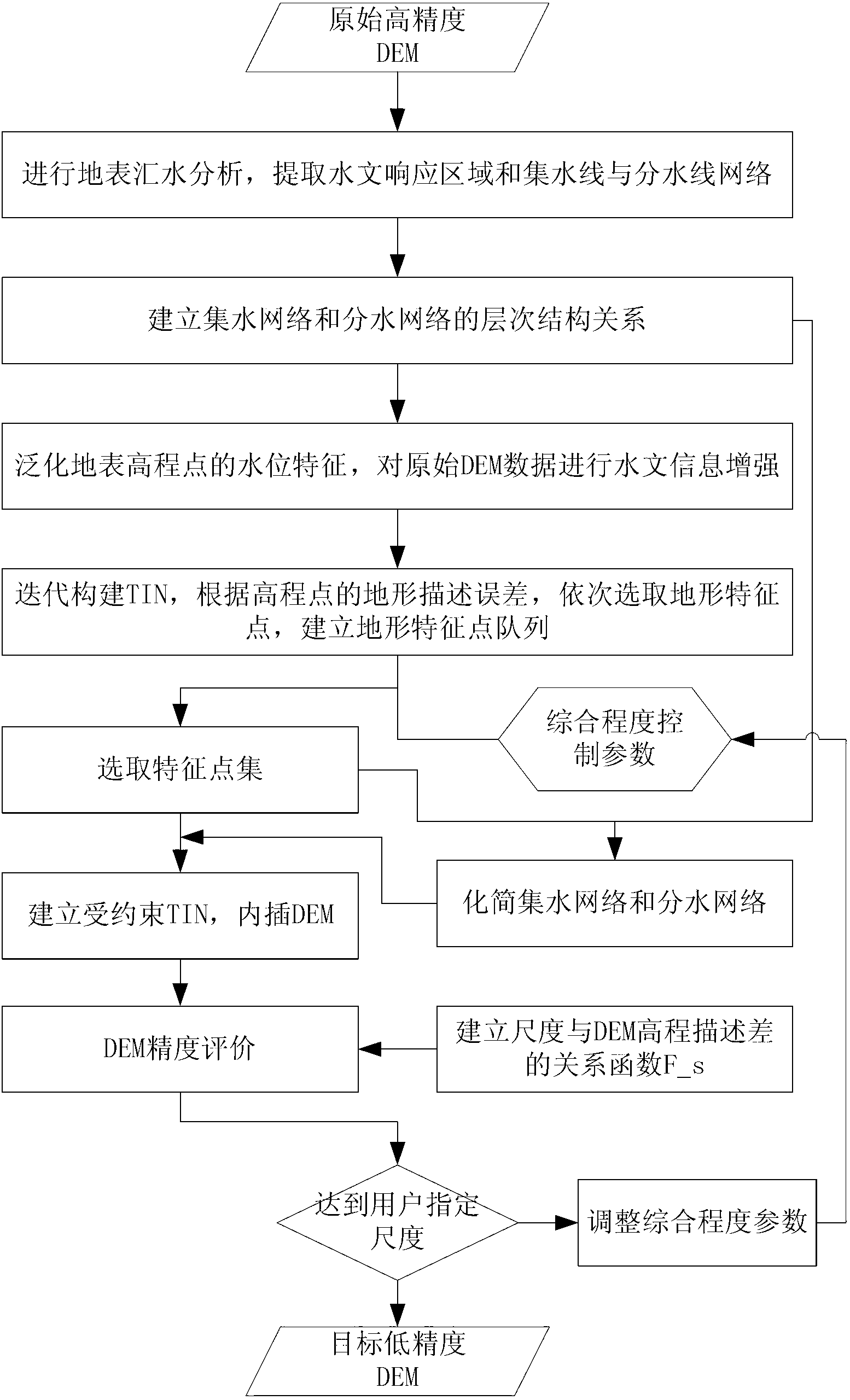
The invention belongs to the field of modeling of a DEM (digital elevation model) and particularly relates to a multiscale DEM modeling method giving consideration to contents of surface hydrology. By carrying out runoff analysis on the DEM to extract a hydrological response region of a topographical surface, a hierarchical structure tree of a watershed area is established; by generalizing hydrological characteristics of a surface elevation point, a hydrological contribution index of the elevation point for a topographic form is calculated; by inspecting weighted topography description error of the elevation point, topographic feature point set is selected; and an elastic position seeking strategy is adopted to automatically regulate an integration degree control parameter so as to implement multiscale DEM automatic integration giving consideration to the contents of surface hydrology. Therefore, the multiscale DEM modeling method has the following advantages that topographic and hydrological features of an original high-accuracy DEM can be effectively kept and topological and logic consistency of the topographic and hydrological features of the multiscale DEM can be ensured; and automation and generating efficiency of the multiscale DEM modeling are improved and the requirement on the scale self-adaptation DEM in the practical application can be met.

Description

technical field [0001] The invention relates to a multi-scale DEM modeling method, in particular to a multi-scale DEM modeling method considering the surface hydrological context. Background technique [0002] Digital elevation model (Digital Elevation Model, DEM), as a digital description and simulation method of the earth's surface terrain, is an important part of the spatial data infrastructure. Has a wide range of applications. In order to meet the needs of different levels, all countries have established multi-scale (or multi-resolution) DEM databases in the way of coexistence of multiple scales. For example, NASA, the National Mapping Agency of the Ministry of Defense (NIMA), and the German and Italian Space Agencies have established SRTM3DEM with a resolution of 90 meters, SRTM1DEM with a resolution of 30 meters and ASTER DEM with a resolution of 15 meters. The Landmap DTM with a resolution of 25 meters and the Bluesky DTM with a resolution of 5 meters have been esta...

Claims


Application Information

Patent Timeline
IPC IPC(8): G06T17/05
Inventor 黄丽娜郑斌费立凡李跃
Owner WUHAN UNIV
Learn More