Intelligent navigation method and system based on road condition prediction

A technology of intelligent navigation and road conditions, which is applied in the field of navigation systems, can solve problems such as lack of flexibility, inaccurate routes, and inability to plan routes, and achieve the effect of improving flexibility and accuracy

Active Publication Date: 2013-08-14
TENCENT TECH (SHENZHEN) CO LTD +1
View PDF4 Cites 47 Cited by
  • Summary
  • Abstract
  • Description
  • Claims
  • Application Information

AI Technical Summary

Problems solved by technology

[0004] However, due to the need to obtain real-time road conditions, it is impossible to plan routes in advance according to the determined travel time, which lacks flexibility. Since real-time road conditions can only obtain current road conditions, and road conditions will change during driving, the pre-calculated route is not accurate enough

Method used


Image

  • Intelligent navigation method and system based on road condition prediction
  • Intelligent navigation method and system based on road condition prediction
  • Intelligent navigation method and system based on road condition prediction

Examples


Embodiment Construction

[0073] The technical solution of the intelligent navigation method and system based on road condition prediction will be described in detail below in conjunction with specific embodiments and accompanying drawings.

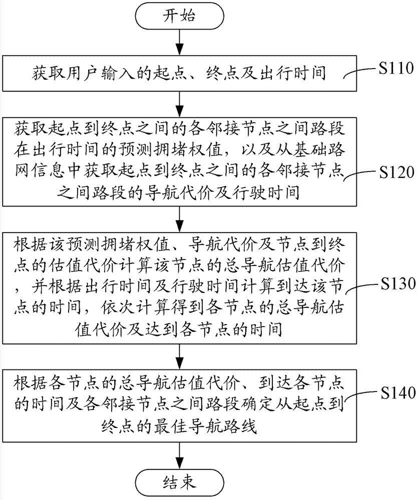
[0074] Such as figure 1 As shown, in one embodiment, a kind of intelligent navigation method based on traffic condition prediction, comprises the following steps:

[0075] Step S110, acquiring the start point, end point and travel time input by the user.

[0076] The user inputs the start point, end point and travel time on the operation interface, such as figure 2 As shown, the starting point is Beijing-Tonghui North Road, the end point is Beijing-Dongdan, and the travel time is 17:00 on Wednesday. You can also choose not to consider avoiding congestion, avoiding congestion according to current road conditions, and avoiding according to road condition predictions Congestion etc.

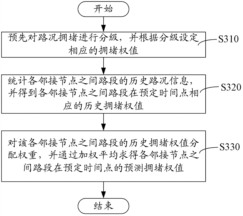
[0077] Step S120, obtain the predicted congestion weights of the road sections ...


PUM


Abstract

The invention relates to an intelligent navigation method and an intelligent navigation system based on road condition prediction. The intelligent navigation method comprises the following steps of: obtaining the staring point, the finishing point and the travel time of a user; obtaining predication congestion weights of rod sections of adjacent nodes between the staring point and the finishing point during the travel time, obtaining navigation costs and running time of the rod sections of the adjacent nodes between the staring point and the finishing point from basic road network information; calculating the total navigation estimation cost of the node according to the predication congestion weight, the navigation cost and an estimation cost from the staring point to the finishing point, calculating the time for achieving the node according to the travel time and the running time, and calculating in order to obtain the total navigation estimation costs of the nodes and the time for reaching the nodes; and obtaining the optimal navigation course from the staring point to the finishing point according to the total navigation estimation costs of the nodes, the time for reaching the nodes and determined rod section of the adjacent modes. With the method and the system, the flexibility and the accuracy of the navigation course are improved.

Description

【Technical field】 [0001] The invention relates to a navigation system, in particular to an intelligent navigation method and system based on road condition prediction. 【Background technique】 [0002] Planning the best driving route in the navigation road network is a basic function of the map. Commonly used driving navigation strategies include the shortest time, the shortest route, etc. These algorithms generally search for routes in static road networks. [0003] The actual optimal driving route is often closely related to road conditions. The traditional optimization method is to select the optimal route in combination with real-time road conditions. The working method is: obtain alternative routes according to the user's starting point and destination; The weight of inherent attributes; according to the real-time monitoring information, the searched route is weighted and scored, and the driving route is selected according to the weighted score. [0004] However, due to...

Claims


Application Information

Patent Timeline
Patent Type & Authority Applications(China)
IPC IPC(8): G01C21/26G01C21/34
Inventor 彭蔚林夏祥熊科浪江红英
Owner TENCENT TECH (SHENZHEN) CO LTD
Why Eureka
Try Eureka