Method for extracting remote sensing image interesting area based on multi-scale feature fusion

A technology of region of interest and multi-scale features, which is applied in the field of region-of-interest extraction of remote sensing images based on multi-scale feature fusion, can solve problems such as undetectable, low resolution of salient images, missed regions, etc., to improve efficiency and The effect of accuracy, low computational complexity, and good application value

Inactive Publication Date: 2013-09-04
BEIJING NORMAL UNIVERSITY
View PDF2 Cites 23 Cited by
  • Summary
  • Abstract
  • Description
  • Claims
  • Application Information

AI Technical Summary

Problems solved by technology

[0005] Although the above visual attention methods have many advantages, they have many disadvantages when directly applied to remote sensing images, especially in high spatial resolution remote sensing images.
For example, the resolution of the saliency map generated by the ITTI method and the GBVS method is too low to achieve an accurate description of the region of interest in the remote sensing image, and many important regions will be missed
The WT method produces a saliency map of the same size as the original image, but the saliency map contains many fragmented regions
The SR method reduces the original image to 64×64 pixels and then calculates the spectral residual, and generates a saliency map based on a single low-scale image. Although it is conducive to the rapid extraction of the region of interest, it will cause the edge of the region to be too

Method used


Image

  • Method for extracting remote sensing image interesting area based on multi-scale feature fusion
  • Method for extracting remote sensing image interesting area based on multi-scale feature fusion
  • Method for extracting remote sensing image interesting area based on multi-scale feature fusion

Examples


Embodiment Construction

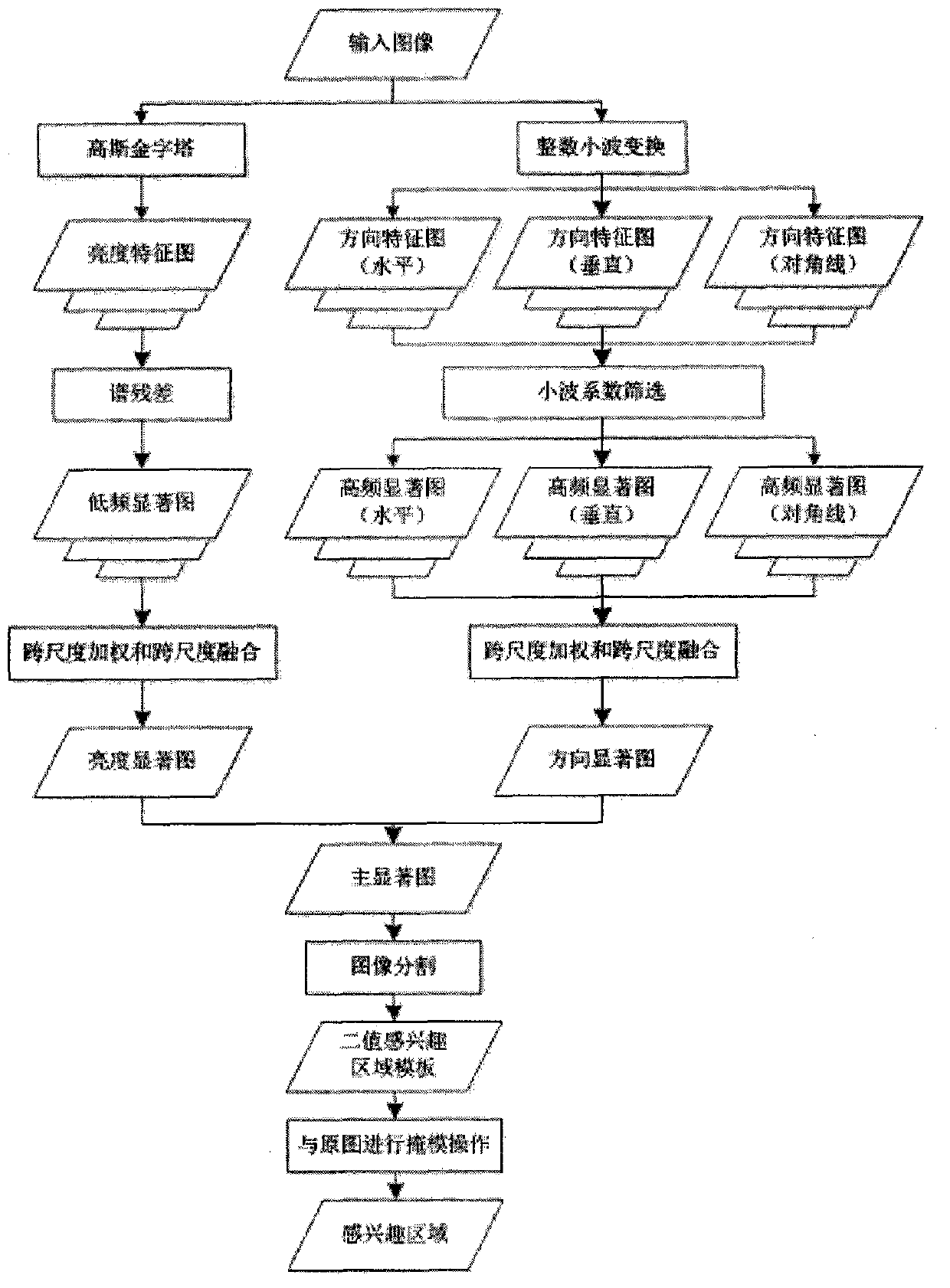
[0042] The present invention will be further described below in conjunction with the accompanying drawings. figure 1 The flow chart of the method of the present invention is shown, and the implementation details of each step are now introduced.

[0043] Step 1: Use the n-level Gaussian pyramid to obtain the multi-scale low-frequency components of the remote sensing image to form a multi-scale brightness feature map, and then use the saliency analysis method based on the multi-scale spectral residual (MSSR, Multi-Scale Spectral Residual) to analyze each scale The spectral residual calculation is performed on the luminance feature map above, and the corresponding visual saliency information is extracted, and finally the multi-scale low-frequency saliency map of the remote sensing image is formed.

[0044] In this step, Gaussian pyramid processing is first performed on the input panchromatic remote sensing image, that is, Gaussian low-pass filtering is performed on the image, and...


PUM


Abstract

The invention discloses a method for extracting a remote sensing image interesting area based on multi-scale feature fusion, and belongs to the technical field of remote sensing image processing. The method comprises the following steps: (1) adopting a saliency analysis method based on a multi-scale spectrum residual error to generate a multi-scale low frequency saliency image of the remote sensing image, (2) obtaining multi-scale high frequency saliency images in the horizontal direction, the perpendicular direction and the diagonal direction through integer wavelet transformation, (3) obtaining a luminance saliency image and a direction saliency image through cross-scale weighting and cross-scale fusion, (4) combining the luminance saliency image and the direction saliency image to generate a main saliency image, and (5) carrying out threshold segmentation to extract the interesting area through the OTSU. Compared with a traditional method, the method has the advantages of being low in computing complexity and effectively improving area extraction efficiency and area extraction accuracy. Due to the fact that spectrums and color information of the remote sensing image are not required to be obtained, the method can be directly used for interesting area extraction of a high-resolution full-color remote sensing image. The method has good application value in the fields of land planning, environment monitoring, forestry investigation and the like.

Description

technical field [0001] The invention belongs to the technical field of remote sensing image processing, and relates to a remote sensing image interest region extraction method based on multi-scale feature fusion. Background technique [0002] With the rapid increase of the spatial resolution of remote sensing images, the time for analyzing and processing massive remote sensing data has increased sharply, and research on more efficient and fast remote sensing image processing methods has become an urgent topic. Accurate extraction of regions, and then targeted analysis and processing” provides a good idea to effectively reduce the complexity of massive remote sensing data analysis and processing and reduce processing time, and is also a research hotspot in the field of remote sensing image processing technology. [0003] Visual attention methods have received more and more attention due to their advantages of fast and accurate extraction of regions of interest without prior k...

Claims


Application Information

Patent Timeline
IPC IPC(8): G06T7/00G06T7/60G06T5/00
Inventor 张立保李浩杨凯娜丘兵昌
Owner BEIJING NORMAL UNIVERSITY
Why Eureka
Try Eureka