Distance information obtaining method for temperature correction of thermal infrared imager

A technology of infrared thermal imager and distance information, which is applied in the direction of measuring distance, radiation pyrometry, instruments, etc., and can solve the problem of laser rangefinder measuring infrared thermal imager and ground objects, affecting the accuracy of temperature images, maintenance High cost and other issues, to achieve the effect of novel design ideas

Active Publication Date: 2013-09-11
北京航天益来电子科技有限公司
View PDF3 Cites 11 Cited by
  • Summary
  • Abstract
  • Description
  • Claims
  • Application Information

AI Technical Summary

Problems solved by technology

However, it is not advisable to use a laser rangefinder to measure the distance between the infrared thermal imager and the object to be photographed in the forest fire prevention monitoring system. In addition, the forest fire monitoring system needs to work 24 hours a day, and the lasers in the laser range finder are vulnerable parts, so the maintenance cos...

Method used


Image

  • Distance information obtaining method for temperature correction of thermal infrared imager
  • Distance information obtaining method for temperature correction of thermal infrared imager
  • Distance information obtaining method for temperature correction of thermal infrared imager

Examples


Embodiment Construction

[0032] The following will clearly and completely describe the technical solutions in the embodiments of the present invention with reference to the accompanying drawings in the embodiments of the present invention. Obviously, the described embodiments are only some, not all, embodiments of the present invention. Based on the embodiments of the present invention, all other embodiments obtained by persons of ordinary skill in the art without making creative efforts belong to the protection scope of the present invention.

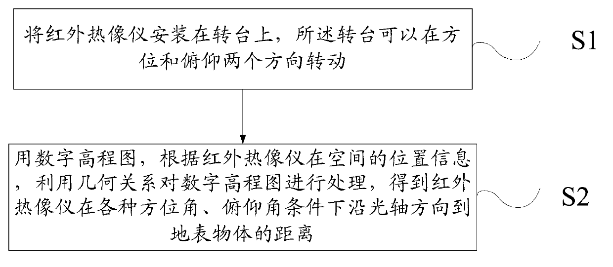
[0033] Such as figure 1 As shown, it is a flow chart of a distance information acquisition method for temperature correction of an infrared thermal imager in the present invention. The distance information acquisition method for temperature correction of an infrared thermal imager in the present invention includes the following steps:

[0034] Step S1: install the infrared thermal imaging camera on the turntable, the turntable can rotate in two directions of a...


PUM


Abstract

The invention provides a distance information obtaining method for temperature correction of a thermal infrared imager. The distance information obtaining method comprises the following steps of: S1. installing the thermal infrared imager on a rotary platform, wherein the rotary platform is capable of rotating in the orientation direction and the pitching direction; S2. processing a digital elevation model by using a geometrical relationship according to position information of the thermal infrared imager in the space to obtain distances between the thermal infrared imager and an object on the earth surface along the direction of optical axis under various orientation angles and pitching angles. According to the distance information obtaining method, the distances between the thermal infrared imager and the object on the earth object along the direction of optical axis under various orientation angles and pitching angles can be calculated by using a method for calculating the distance between the object and the earth surface according to the position information of the thermal infrared imager in space and the digital elevation model of a working region of the thermal infrared imager.

Description

technical field [0001] The invention relates to a distance information acquisition method, in particular to a distance information acquisition method for temperature correction of an infrared thermal imager. Background technique [0002] Forest fire is the most dangerous enemy of the forest and the most terrible disaster of forestry. It will bring the most harmful and destructive consequences to the forest. Forest fires not only burnt patches of forest and harmed the animals in the forest, but also reduced the regeneration ability of the forest, caused soil barrenness and destroyed the forest's ability to conserve water, and even led to an imbalance in the ecological environment. Although science in today's world is advancing with each passing day, human beings have not yet made long-term progress in subduing forest fires. [0003] At present, most forest fire monitoring systems use visible light cameras to monitor forest fires, and use the color and texture of flames to id...

Claims


Application Information

Patent Timeline
IPC IPC(8): G01C3/00G01J5/00
Inventor 徐大新周斌郭莲英
Owner 北京航天益来电子科技有限公司
Why Eureka
Try Eureka