Vehicular Ad hoc Network vehicle positioning method based on in-vehicle inertia device

An inertial device and vehicle positioning technology, which is applied in the field of Internet of Vehicles, can solve the problems of low positioning accuracy, shortening the first GPS positioning time, and unable to completely solve GPS blind spot positioning, etc.

Inactive Publication Date: 2013-09-25
NANJING UNIV OF POSTS & TELECOMM +1
View PDF4 Cites 39 Cited by
  • Summary
  • Abstract
  • Description
  • Claims
  • Application Information

AI Technical Summary

Problems solved by technology

At present, the industry uses AGPS to assist GPS positioning through the information of mobile phone base stations, which can shorten the first positioning time of GPS. In places where the signal cannot be received, the cell-id of the base station can be used to locate, but the positioning accuracy is not high, and it still cannot be completely solved. Positioning problem in GPS blind area

Method used


Image

  • Vehicular Ad hoc Network vehicle positioning method based on in-vehicle inertia device
  • Vehicular Ad hoc Network vehicle positioning method based on in-vehicle inertia device
  • Vehicular Ad hoc Network vehicle positioning method based on in-vehicle inertia device

Examples


Embodiment Construction

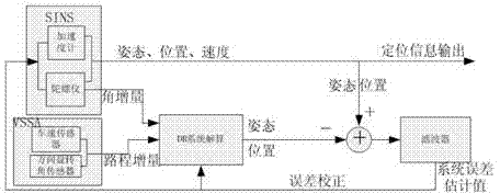
[0052] The technical solution of the present invention will be further described below in conjunction with the accompanying drawings.

[0053] Because in the method of the present invention, there is an error in the measured value of the inertial device in the vehicle, especially there is a random error in the measured angle, in order to make the simulation result closer to the real scene, in the simulation process, according to the above-mentioned mathematics model, artificially added random noise.

[0054] (1) Simple scene simulation analysis

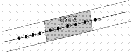
[0055] The parabola approximated as a straight line is selected as the actual driving trajectory, the dotted line represents the actual trajectory, and the solid line represents the trajectory fitted by the position points obtained by the method of the present invention. From Figure 7 It can be seen that when the curvature change is relatively small, the trajectory obtained by the VSSA method is consistent with the actual trajector...


PUM


Abstract

The invention mainly researches a positioning problem when GPS signals are blocked according to vehicle positioning requirements in the Vehicular Ad hoc Network (VANET), and provides a VANET vehicle positioning method based on an in-vehicle inertia device. With the method, a vehicle self positioning capacity when the GPS signals are blocked is improved. With the method provided by the invention, with a vehicle speed sensor, vehicle running speed can be detected; a heading angle is detected with a steering wheel rotation angle sensor; distance increment projection is carried out according to kinematic laws; and the position information of the vehicle at a next time point is obtained, and vehicle self positioning when the GPS signals are blocked is realized. With the method, a combined positioning method is innovated. A dead reckoning (DR) system is composed of gyroscopes in a VSSA system and a SINS system. With the positions and attitude errors of the DR system and the SINS system, and through Sage-husa self-adaptive filtering, the SINS system is compensated, such that SINS system output with relatively high precision can be obtained.

Description

technical field [0001] The invention relates to the technical field of the Internet of Vehicles, in particular to a vehicle positioning method in the Internet of Vehicles based on an inertial device in the vehicle. Background technique [0002] With the rapid development of the economy, my country's car ownership continued to grow, reaching 90.86 million in 2010 [1] , the increase in car ownership has brought great challenges to the traffic management system. Intelligent Transportation System (ITS [2] , Intelligent Transportation System), as an integrated traffic management system, provides the possibility to deal with this challenge, and it is the development direction of the future traffic system. ITS effectively integrates advanced information technology, electronic sensing technology, data communication transmission technology, control technology and computer technology, and then applies it to the entire ground traffic management system to provide a wide range, all-rou...

Claims


Application Information

Patent Timeline
Patent Type & Authority Applications(China)
IPC IPC(8): G01C21/28G01S19/49
Inventor 刘南杰赵璐黄波赵海涛李大鹏
Owner NANJING UNIV OF POSTS & TELECOMM
Why Eureka
Try Eureka