Inertial navigation system polar navigation parameter calculating method

An inertial navigation system and a navigation parameter technology, which is applied in the field of navigation parameter calculation in the polar region of the inertial navigation system, and can solve the problems of navigation monitoring and navigation mapping of unfavorable navigators, increase of calculation errors of sky components, and influence of navigation parameter calculation errors. and other problems to achieve the effect of facilitating navigation monitoring

Inactive Publication Date: 2013-10-02
NAVAL UNIV OF ENG PLA
View PDF2 Cites 17 Cited by
  • Summary
  • Abstract
  • Description
  • Claims
  • Application Information

AI Technical Summary

Problems solved by technology

This is because the calculation error of the celestial component of the rotational angular velocity of the geographic coordinate system relative to the earth coordinate system increases as the latitude increases, which in turn affects the calculation error of the navigation parameters directly related to it.
[0005] 2. The geographic heading calculated by the inertial navigation system cannot meet the needs of navigation in polar regions
This is because the rapid convergence of the geographic meridian causes the carrier to continuously and rapidly change the heading angle when navigating along the great circle route, which is not conducive to the navigation monitoring and navigation calculation of the navigator, so the geographic heading is no longer applicable to the polar region navigation

Method used


Image

  • Inertial navigation system polar navigation parameter calculating method
  • Inertial navigation system polar navigation parameter calculating method
  • Inertial navigation system polar navigation parameter calculating method

Examples


Embodiment

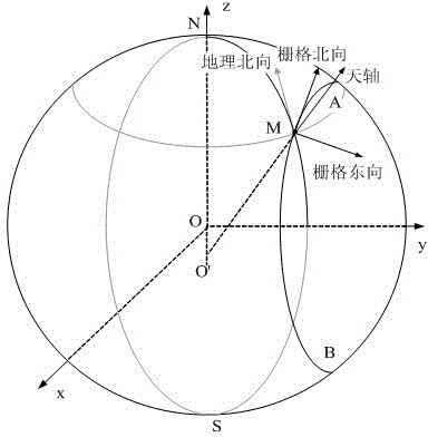
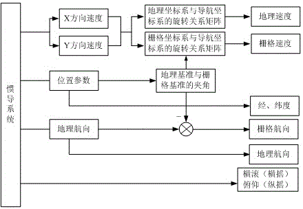
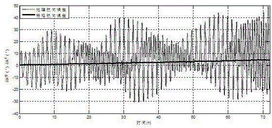
[0063] In order to compare INS raster heading and velocity errors with geographic heading and velocity errors, the analysis is performed under the following conditions:

[0064] (1) The inertial navigation system is a wandering azimuth inertial navigation system;

[0065] (2) The carrier velocity is , the initial latitude is 88°N, and the initial longitude is 120°;

[0066] (3) The constant drift of the gyro is 0.001° / h, and the random drift is 0.001° / h; the constant zero bias of the accelerometer is 10 -5 g, with a random error of 10 -5 g;

[0067] (4) The initial error of inertial navigation information is: the horizontal attitude error is 10", the azimuth error is 20", the position error is 10m, and the horizontal velocity error is 0.05m / s;

[0068] (5) The simulation time is 72h.

[0069] The simulation comparison curves of geographic heading error and grid heading error and the simulation comparison curves of geographic north speed error and grid north speed error a...


PUM


Abstract

The invention relates to the fields of navigation technology and the like and concretely relates to an inertial navigation system polar navigation parameter calculating method. The method calculates navigation parameters which are suitable for polar navigation by constructing an ellipsoidal surface grid course reference model and utilizing navigation information of the inertial navigation system in a navigation coordinate system. The navigation parameters are applied to navigation calculating modules of the inertial navigation system, and the inertial navigation system can output the polar navigation parameters directly. The polar navigation performance of the inertial navigation system is raised, and the requirement of safe polar navigation of carriers is meet.

Description

technical field [0001] The invention relates to the fields of navigation technology and the like, in particular to a method for calculating polar area navigation parameters of an inertial navigation system. Background technique [0002] With the vigorous development of aviation and navigation and the further development and utilization of the polar region, it is even more important to correctly implement the navigation and positioning of the polar region to ensure the safe and effective navigation of the carrier in the polar region. [0003] However, the navigation environment in polar regions is very complex, which affects the normal use of various existing navigation equipment and the safe operation of navigators. The inertial navigation system has the advantages of autonomy, anti-interference, concealment, etc., making it a necessary navigation method in the military, and it is also particularly important in the polar region navigation with complex environments. However,...

Claims


Application Information

Patent Timeline
Patent Type & Authority Applications(China)
IPC IPC(8): G01C21/16
Inventor 卞鸿巍刘文超王荣颖温朝江马恒范崧伟张宇辛
Owner NAVAL UNIV OF ENG PLA
Why Eureka
Try Eureka