Scaling buoy of three-antenna multi-mode GNSS (Global Navigation Satellite System) satellite height gauge

An altimeter and three-antenna technology, used in radio wave measurement systems, measurement devices, instruments, etc., can solve the problem of not being able to give the instantaneous attitude angle of buoys, affecting the accuracy of GNSS buoys, etc., to improve the resolution accuracy, improve accuracy and reliability. Sexual, high information content effects

Inactive Publication Date: 2013-10-23
鲍李峰
View PDF5 Cites 17 Cited by
  • Summary
  • Abstract
  • Description
  • Claims
  • Application Information

AI Technical Summary

Problems solved by technology

[0010] At present, the main problem faced by single-antenna GNSS buoys is that only one GNSS antenna cannot provide the instantaneous attitude angle of the buoy. The phase center of the antenna should be placed on the center of mass of the buoy as much as possible, but s

Method used


Image

  • Scaling buoy of three-antenna multi-mode GNSS (Global Navigation Satellite System) satellite height gauge
  • Scaling buoy of three-antenna multi-mode GNSS (Global Navigation Satellite System) satellite height gauge
  • Scaling buoy of three-antenna multi-mode GNSS (Global Navigation Satellite System) satellite height gauge

Examples


Embodiment Construction

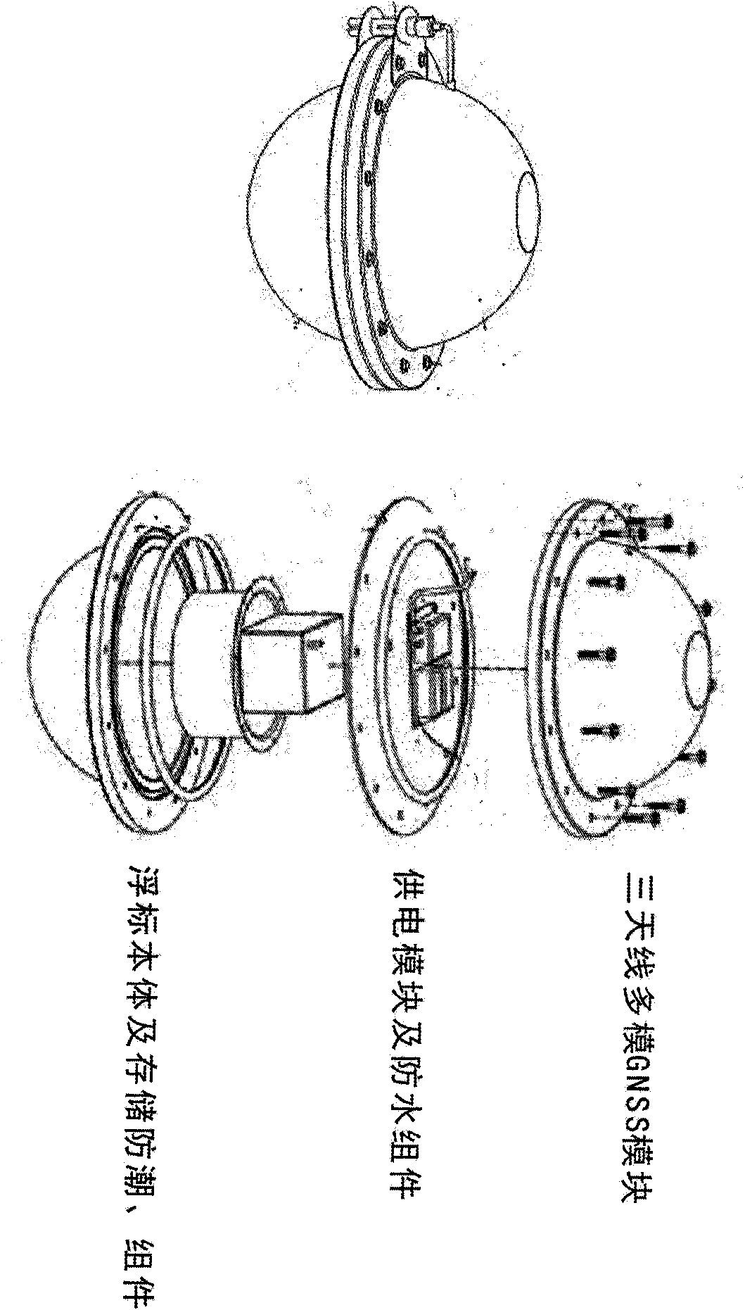
[0020] Three-antenna multi-mode GNSS buoy mainly consists of three modules, including GNSS antenna and receiver module; buoy power supply and waterproof module; buoy body and data storage, moisture-proof module.

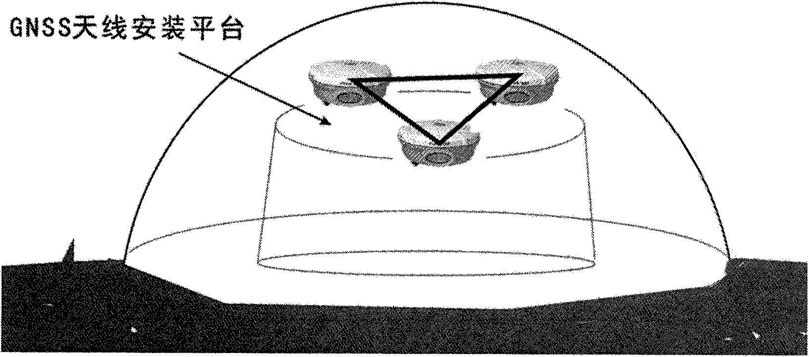
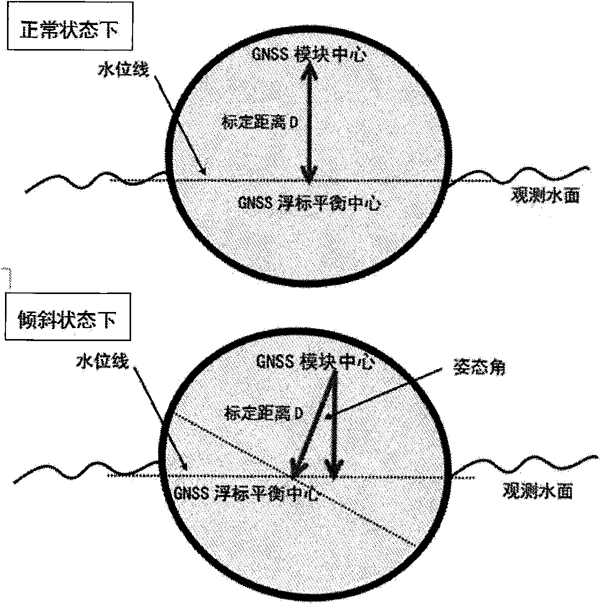
[0021] The three-antenna multi-mode GNSS module consists of three GNSS antennas and receivers. The three GNSS are respectively installed at the vertices of an equilateral triangle on the GNSS platform. The three GNSS antennas are located on the same plane, and the distance between the phase centers of the three antennas Measured precisely. The geometric center of an equilateral triangle is marked on the platform with a steel measurement marker. Accurately measure the distance from the geometric center of an equilateral triangle to each antenna. The entire GNSS platform is above the waterline of the buoy at a set height. When the GNSS buoy is at a normal level, the observation value of the water surface height measurement can be obtained by deducting the fixed heigh...


PUM


Abstract

The invention relates to a sea level height scaling buoy of a satellite height gauge, wherein the seal level height scaling buoy is mainly used for accurately determining sea level height and belongs to the technical field of ocean monitoring instruments. The scaling buoy fills the blank of GNSS scaling buoy high-accuracy instruments of the satellite height gauge, a three-antenna multi-mode GNSS is introduced for completely utilizing the superiority of three-antenna combination and accurately calculating instantaneous gesture of the GNSS scaling buoy, so that the accuracy and reliability of determining the water level height of the GNSS scaling buoy are improved. The scaling buoy overcomes the defects of too small distance between antennas and water level and great influence on water level multi-path effect caused by the fact that the antenna phase center of the GNSS and the barycenter of the scaling buoy are overlapped, and the designed three-antenna multi-mode GNSS scaling buoy can extend a GNSS observation module over the water level, so that the influence of water level multi-path effect on GNSS positioning resolving accuracy is prevented. The scaling buoy is applied to the satellite height gauge for observing accurate scaling.

Description

technical field [0001] The patent of the invention relates to a satellite altimeter sea surface height calibration buoy, which is mainly used for the precise determination of sea level height and belongs to the technical field of marine monitoring instruments. Background technique [0002] Satellite altimeter is a rapidly developing high-tech measurement technology. Its research and application fields cover almost all aspects related to ocean height. The precise quantitative research on changes provides strong support. Satellite altimetry technology can monitor the global sea level and marine dynamic environment for a long time around the clock, and can obtain important parameters including sea surface height, sea surface wind field, wave field, sea current, temperature, tide and other sea conditions. These parameters and data are used in marine scientific research, It plays an important role in maritime military activities and national economic construction services. [0...

Claims


Application Information

Patent Timeline
IPC IPC(8): G01F25/00G01S7/40
Inventor 鲍李峰
Owner 鲍李峰
Why Eureka
Try Eureka