City environment robot navigation method based on multi-layer probabilistic terrain

A technology of urban environment and navigation method, applied in the direction of instruments, image data processing, 3D modeling, etc., can solve the problems of insufficient expression of urban environment, lack of fault tolerance and robustness, weak autonomous navigation ability, etc., and achieve good economic benefit, ensure real-time performance, and improve the effect of accuracy

Inactive Publication Date: 2013-11-20
SOUTHEAST UNIV
View PDF4 Cites 13 Cited by
  • Summary
  • Abstract
  • Description
  • Claims
  • Application Information

AI Technical Summary

Problems solved by technology

[0005] The purpose of the present invention is to overcome the existing technical defects, and to solve the defects in the modeling and autonomous navigation methods of mobile robots in specific urbanization environments, which are easily affected by various uncertainties, insufficient expression

Method used


Image

  • City environment robot navigation method based on multi-layer probabilistic terrain
  • City environment robot navigation method based on multi-layer probabilistic terrain
  • City environment robot navigation method based on multi-layer probabilistic terrain

Examples


Embodiment Construction

[0020] The present invention will be further described below in conjunction with the accompanying drawings and specific embodiments.

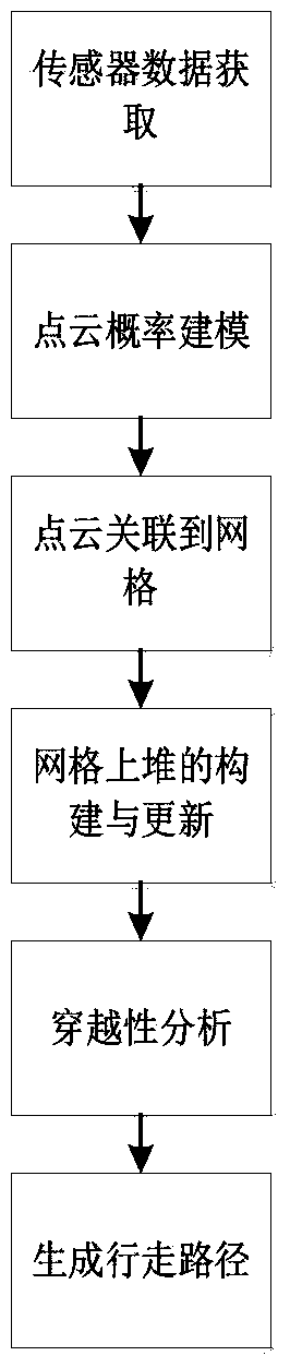
[0021] figure 1 The overall flowchart of the urban environment robot navigation method based on probabilistic multi-layer terrain proposed by this patent, the specific steps of the algorithm are as follows:

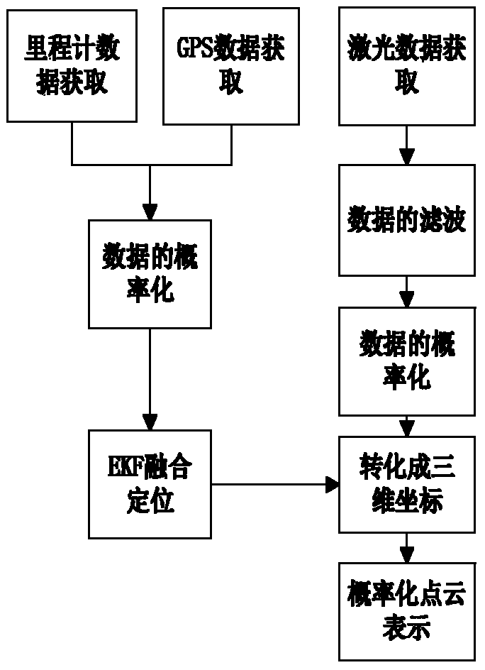
[0022] 1. Acquisition of 3D terrain information and generation of probabilistic point clouds

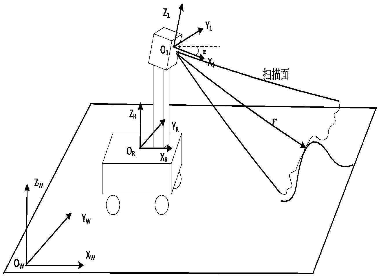
[0023] The acquisition of three-dimensional environmental data is the prerequisite for subsequent terrain modeling. First, the distance information of the surrounding environment is obtained through a two-dimensional laser sensor; secondly, the laser measurement data, odometer and GPS data are probabilized through a Gaussian model; and then the Kalman The filtering method uses the odometer and GPS data to fuse and position the robot to obtain the global coordinates of the robot's current position; finally, by combining the current global coordin...


PUM


Abstract

The invention discloses a city environment robot navigation method based on multi-layer probabilistic terrain. The method comprises the steps as follows: firstly, performing scanning, filtering and probability transformation on the terrain by a low-cost laser sensor mounted on a tripod head to obtain randomization point cloud representation under world coordinates, then associating point cloud data with a plurality of corresponding grids with a gridding terrain division method, performing probability fusion on the point cloud data associated in the grids so as to form heap data capable of representing the multi-layer terrain and complete the modeling process of the terrain, and finally, performing traversing performance analysis on the obtained multi-layer probabilistic terrain to form a safe and efficient robot walking path. According to the invention, under the premise of ensuring real-time performance, accurate modeling and navigation on the city terrain environment are realized through randomization treatment and introduction of a multi-layer heap structure, and the city environment robot navigation method has very important economic value and application prospect in related fields such as three-dimensional city navigation service, reconnaissance and rescue and GIS.

Description

technical field [0001] The invention relates to a method for urban environment robot navigation based on probabilistic multi-layered terrain, especially a terrain-accurate modeling and navigation method for a mobile robot in a large-scale urbanized environment, belonging to urban three-dimensional navigation service, ground or air unmanned autonomous platform technology , Geographic Information System (GIS) and other application fields. Background technique [0002] With the increasing expansion of application fields such as unmanned autonomous driving, military reconnaissance and rescue, unmanned aerial vehicles, and urban three-dimensional navigation services, the research on terrain modeling and navigation capabilities of mobile robots in specific urban environments is becoming increasingly important in the industry. hot issues, and gradually produced a wider range of economic needs. These requirements are different from the existing indoor mobile robot modeling methods,...

Claims


Application Information

Patent Timeline
IPC IPC(8): G06T17/05
Inventor 周波戴先中马旭东李孟
Owner SOUTHEAST UNIV
Why Eureka
Try Eureka