Linear-interpolation-based cloud image profile projection method

A linear interpolation, meteorological cloud map technology, applied in aircraft ground control, special data processing applications, instruments, etc., can solve problems such as the inability to express the cloud map level, the inability to obtain cloud base height data, and the increase of workload.

Active Publication Date: 2013-12-18
NANJING LES INFORMATION TECH
View PDF7 Cites 8 Cited by
  • Summary
  • Abstract
  • Description
  • Claims
  • Application Information

AI Technical Summary

Problems solved by technology

[0010] The existing air traffic control automation system, using MAX data to display the cloud map can only give a reference on the coverage of the cloud, and the height data of the cloud base cannot be obtained through this projection map
It only shows the horizontal position of the cloud image and the level of the cloud image, but cannot express the level of the cloud image at each altitude layer
[0011] There are also many disadvantages in the daily work of the controllers by using the weather monitoring system to observe the cloud picture
Due to the split-screen display of the cloud map and the situation, when checking the weather conditions on the route, it is necessary to locate on the display interface of the weather monitoring system through latitude and longitude, which increases unnecessary workload

Method used


Image

  • Linear-interpolation-based cloud image profile projection method

Examples


Embodiment Construction

[0025] Below in conjunction with accompanying drawing and specific embodiment, further illustrate the present invention, should be understood that these embodiments are only for illustrating the present invention and are not intended to limit the scope of the present invention, after having read the present invention, those skilled in the art will understand various aspects of the present invention Modifications in equivalent forms all fall within the scope defined by the appended claims of this application.

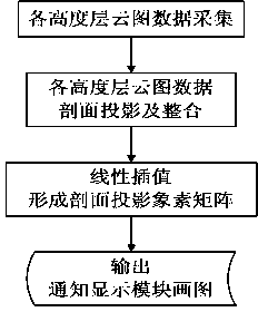
[0026] The invention discloses a linear interpolation-based meteorological cloud image profile projection method, comprising the following steps:

[0027] (1) Acquisition of cloud image data at each altitude layer: Through the pre-processing of the original radar data, the cloud image level data of the radar at multiple altitude layers is obtained, and each altitude layer is separated by a fixed value; among them, a PIX×PIX The matrix expresses the level data of the clou...


PUM


Abstract

The invention discloses a linear-interpolation-based cloud image profile projection method. The method comprises the following steps of performing east-west and south-north projection on an echo data matrix of each flight level in a matrix trace extraction way to obtain a matrix; performing linear interpolation on each column to obtain a continuous profile projection pixel map. The method is mainly used for an automatic air traffic control system for an airport, and the meteorological data of a weather radar and an air traffic situation are fused for display.

Description

technical field [0001] The invention relates to the technical field of meteorological radar data processing, in particular to a method for realizing the profile projection of meteorological cloud charts by using meteorological radar. Background technique [0002] In the process of air traffic control, the weather factor is an important reference element. One of the main reasons for flight accidents and flight delays is that the flight of aircraft is restricted under certain adverse weather conditions. Although airport navigation aids and aircraft performance are becoming more and more advanced, and unfavorable meteorological conditions have less restrictive effects on flight, but for airports and air routes in certain climatic conditions and climate environments, passenger stranded, Flights were delayed in a large area, and did not decrease significantly as the flight volume increased. [0003] Cloud is the most common meteorological factor that affects flight. It is a vis...

Claims


Application Information

Patent Timeline
Patent Type & Authority Applications(China)
IPC IPC(8): G06F19/00G08G5/06
Inventor 张佳静白红利丁立平
Owner NANJING LES INFORMATION TECH
Why Eureka
Try Eureka