Method and device for establishing incremental code library

A code base and incremental technology, applied in the field of geographic information, which can solve the problems of inability to inherit data, manual modification, and low efficiency.

Active Publication Date: 2014-01-15
BEIJING BAIDU NETCOM SCI & TECH CO LTD
View PDF4 Cites 15 Cited by
  • Summary
  • Abstract
  • Description
  • Claims
  • Application Information

AI Technical Summary

Problems solved by technology

This full-scale mining method is firstly inefficient. Every time there is a data update, the mining process needs to be run again on all the data; secondly, the manually modified data cann...

Method used


Image

  • Method and device for establishing incremental code library
  • Method and device for establishing incremental code library
  • Method and device for establishing incremental code library

Examples


Embodiment 1

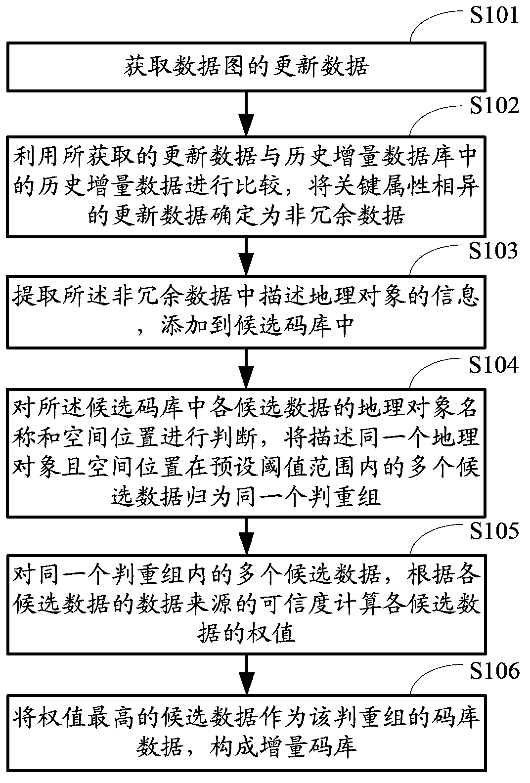
[0094] figure 1 It is a flow chart of the method for establishing the incremental code library provided by this embodiment, such as figure 1 As shown, the method includes:

[0095] Step S101, acquiring update data of the data map.

[0096] The update data of the data map is generally provided by the data provider, and usually includes attribute information such as name, category, address, data provider (Content Provider, CP), spatial location or geometric shape. Alternatively, it may also be updated data after manual correction.

[0097] Among them, the spatial position is usually represented by X and Y coordinate values, and the geometric shape is usually represented by a set of points or a set of polylines.

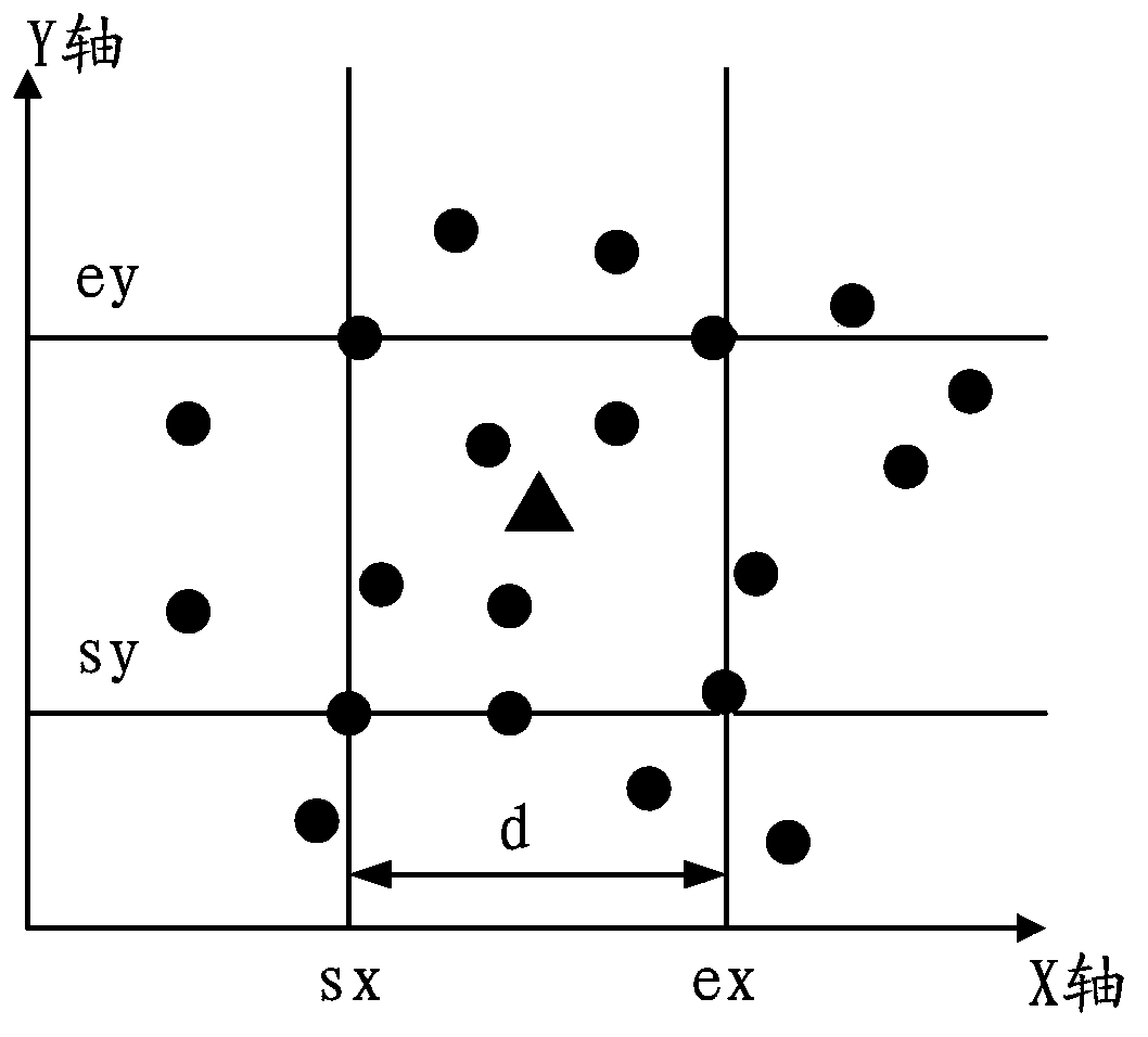
[0098] As shown in Table 1 and Table 2 below, it is an illustration of some updated data provided by data providers NavInfo and MapBar.

[0099] Table 1

[0100] name

[0101] Table 2

[0102]

[0103] Step S102 , comparing the acquired update data wi...

Embodiment 2

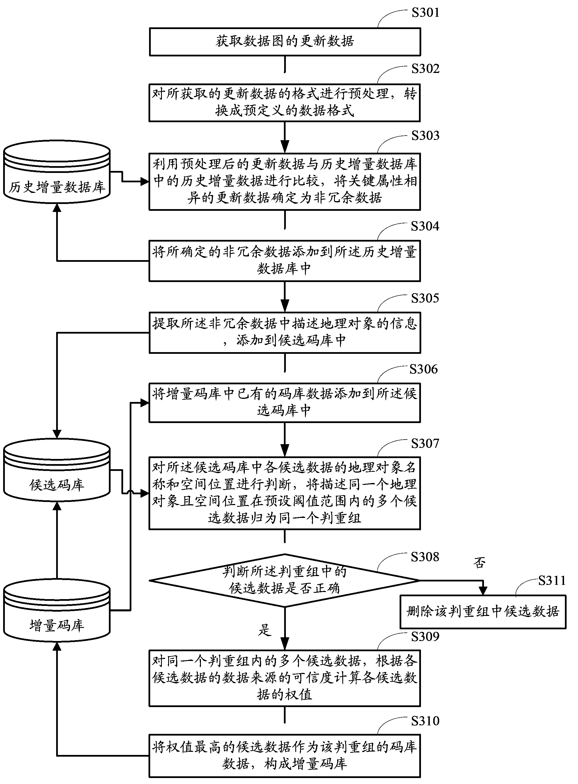
[0154] image 3 It is a flow chart of the method for establishing the incremental code library provided by this embodiment, such as image 3 shown, including:

[0155] Step S301, acquiring update data of the data map.

[0156] This step is the same as step S101 in the first embodiment.

[0157] In this embodiment, the updated data provided by the data providers NavInfo, MapBar and artificial data as shown in Table 6, Table 7 and Table 8 are obtained for description, and the data in Embodiment 1 is used as historical data.

[0158] Table 6

[0159]

[0160] Table 7

[0161]

[0162] Table 8

[0163]

[0164] Step S302, perform preprocessing on the format of the acquired update data, and convert it into a predefined data format.

[0165] The data provided by different data providers are different in file format, data fields, field meanings and value ranges. For example, some data providers provide data in midmif file format, and the text information and spatial i...

Embodiment 3

[0202] Figure 4 It is a schematic diagram of the establishment device of the incremental code library provided by this embodiment. Such as Figure 4 As shown, the device includes:

[0203] The data acquisition module 401 is configured to acquire update data of the data graph.

[0204] The update data of the data map is generally provided by the data provider, and usually includes attribute information such as name, category, address, data provider, spatial location or geometric shape. Alternatively, it may also be updated data after manual correction.

[0205] Among them, the spatial position is usually represented by X and Y coordinate values, and the geometric shape is usually represented by a set of points or a set of polylines.

[0206] As shown in Table 1 and Table 2, it is a schematic representation of some updated data provided by data providers NavInfo and MapBar.

[0207] The homologous comparison module 402 is used to compare the updated data acquired by the da...


PUM


Abstract

The invention provides a method and device for establishing an incremental code library. The method includes the steps that acquired updated data and historical incremental data in a historical incremental database are compared, and the updated data different in key attribute are determined to be non-redundant data; information describing geographic objects is extracted from the non-redundant data and added into a candidate code library; the names of the geographic objects and the spatial positions of all the candidate data in the candidate code library are judged, and multiple candidate data which describe the same geographic object are classified into one same repeating judgment set, wherein the spatial positions of the multiple candidate data are in a preset threshold range; for the multiple candidate date in the same repeating judgment set, the weights of all the candidate data are calculated according to the credibility of data sources of all the candidate data; the candidate data with the highest weight are taken as code library data of the repeating judgment set, and thus the incremental code library is formed. Compared with the prior art, the method and device for establishing the incremental code library can improve data mining efficiency and improve accuracy through repeating judgment and check on the multiple candidate data.

Description

【Technical field】 [0001] The invention relates to the technical field of geographic information, in particular to a method and device for establishing an incremental code library. 【Background technique】 [0002] The code library, also known as the geocode reference database (geocode reference dataset), is a code database set up to identify the position and attributes of points, lines, and surfaces. It selects the most suitable quantification for all entities according to a pre-established classification Method, according to the attribute characteristics of the entity and the data structure of the set coordinates, it is recorded on the storage device of the computer. When performing geocoding, usually according to the geographic coordinates or spatial addresses of each data point (such as provinces, blocks, floors, rooms, etc.), the data in the database is in one-to-one correspondence with the corresponding graphic elements on the map, that is, The process of assigning X and...

Claims


Application Information

Patent Timeline
IPC IPC(8): G06F17/30
CPCG06F16/23G06F16/29
Inventor 林锡通段建国
Owner BEIJING BAIDU NETCOM SCI & TECH CO LTD
Why Eureka
Try Eureka