Navigation locking method and navigation system thereof

The technology of a navigation system and a global positioning system, which is applied in the field of navigation locking method and navigation system, can solve problems such as road locking that cannot be navigated by users, and achieve the effects of preventing travel time, improving quality, and reducing the probability of being late

Inactive Publication Date: 2016-02-03
KUNDA COMP TECHKUSN +1
View PDF9 Cites 0 Cited by
  • Summary
  • Abstract
  • Description
  • Claims
  • Application Information

AI Technical Summary

Problems solved by technology

[0007] In view of the above-mentioned problems in the prior art, one of the purposes of the present invention is to provide a navigation road locking method, in order to overcome the problem in the prior art that the user cannot effectively assist the user in navigating the road locking

Method used


Image

  • Navigation locking method and navigation system thereof
  • Navigation locking method and navigation system thereof
  • Navigation locking method and navigation system thereof

Examples


Embodiment Construction

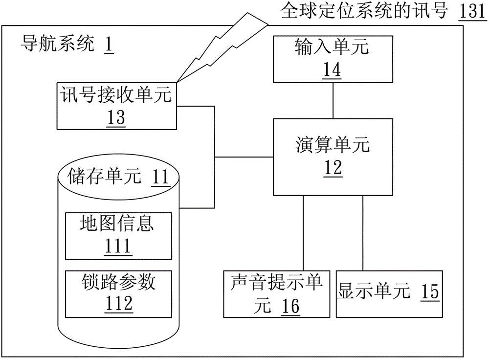
[0036] see figure 1, which is a block diagram of the navigation system of the present invention. In the figure, the navigation system 1 includes: a storage unit 11 , a calculation unit 12 and a signal receiving unit 13 . In the navigation system 1, the signal receiving unit 13 receives the signal 131 of the global positioning system, the signal 131 of the global positioning system includes information such as longitude, latitude and altitude, wherein the calculation unit 12 receives the longitude and latitude according to the signal receiving unit 13 Two-dimensional positioning, or three or more global (satellite) positioning system signals received by the signal receiving unit 13, according to which longitude, latitude and altitude are calculated for three-dimensional positioning. The storage unit 11 stores map information 111 , and the map information 111 includes data of different types of roads, interchanges, topography, longitude and latitude. The calculation unit 12 ca...


PUM


Abstract

The invention discloses a navigation road locking method and a navigation system. The navigation system firstly executes a road type judging procedure so as to set a road locking parameter as a value representing the road types. The method comprises following steps of receiving the signal of a global positioning system and analyzing the current position according to the map information; judging whether another road type different from the road type is available in the error range of the current position; if yes, judging whether an interchange is available in the error range; if not available, locating the current position to the similar roads in the map information according to the road locking parameter. Therefore, the navigation system is prevented from locating the current position at a wrong road, so as to avoid bringing confusion to a user.

Description

【Technical field】 [0001] The present invention relates to a navigation locking method and a navigation system thereof, in particular to a navigation locking method with a locking road type mechanism and a navigation system thereof. 【Background technique】 [0002] At present, the Global Positioning System (GPS, Global Positioning System) has the characteristics of high global coverage, all-weather (not affected by weather), three-dimensional fixed point, positioning, timing, and mobile positioning, which makes the Global Positioning System widely used in various fields. Aspects such as precise timing, observations from observatories, base stations for communication systems, surveying and mapping, satellite navigation, global positioning or construction of roads, bridges or tunnels, etc. Among them, global positioning can also be used in vehicle anti-theft systems, anti-lost systems for children and special groups, or electronic maps. The scope of application of the global po...

Claims


Application Information

Patent Timeline
Patent Type & Authority Patents(China)
IPC IPC(8): G01C21/26G01C21/34
CPCG01C21/3461
Inventor 粘松豪
Owner KUNDA COMP TECHKUSN
Why Eureka
Try Eureka