
Method and system for visualizing dynamic water area by matching with real three-dimensional environment

A water area and three-dimensional technology, applied in image data processing, 3D modeling, instruments, etc., can solve problems such as water flow accumulation, inability to correctly simulate water flow paths, and flow area coverage

Inactive Publication Date: 2014-01-22
CHINESE ACAD OF SURVEYING & MAPPING
View PDF4 Cites 14 Cited by
  • Summary
  • Abstract
  • Description
  • Claims
  • Application Information

AI Technical Summary

Problems solved by technology

However, when this type of water wave model simulates the corresponding water wave range, because the initial elevation of the custom water wave surface is a fixed value, and the water wave range is generally set to the management of four points in the horizontal and vertical planes or the management of the global spherical surface, it cannot be simulated correctly. Water flow path conforming to topographical fluctuations
There are two types of problems in such a simulation, including the flow area of ​​the water flow being covered up due to the high terrain elevation and the phenomenon of water flow accumulation in the non-water flow basin range, and the overall distortion is more or less

Method used


Image

  • Method and system for visualizing dynamic water area by matching with real three-dimensional environment
  • Method and system for visualizing dynamic water area by matching with real three-dimensional environment
  • Method and system for visualizing dynamic water area by matching with real three-dimensional environment

Examples


Embodiment Construction

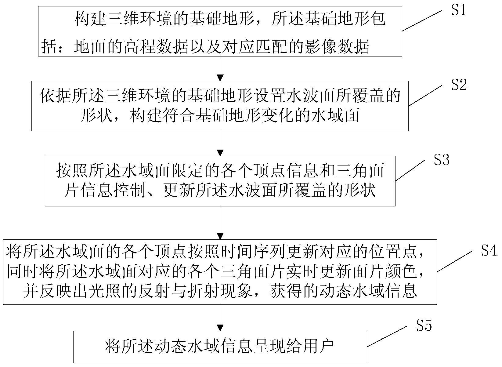
[0049] figure 1 It is a flow chart of the dynamic water visualization method matching the real three-dimensional environment of the present invention. Such as figure 1 As shown, the dynamic water area visualization method matching the real three-dimensional environment of the present invention includes:

[0050] Step 1. Construct a basic terrain of the three-dimensional environment, the basic terrain includes: ground elevation data and corresponding matching image data;

[0051] Step 2: Set the shape covered by the water wave surface according to the basic terrain of the three-dimensional environment, and construct a water surface that conforms to the basic terrain change;

[0052] Step 3: Control and update the shape covered by the water wave surface according to the information of each vertex and triangle surface defined by the water area;

[0053] Step 4, using GPU (graphics processing unit) to update the corresponding position points of the vertices of the water surface in time se...


PUM


Abstract

The invention provides a method for visualizing a dynamic water area by matching with a real three-dimensional environment. The method comprises the following steps of step 1, building a foundation terrain of the three-dimensional environment, wherein the foundation terrain comprises elevation data of the ground and corresponding matched image data; step 2, setting the shape covered by a water wave surface according to the foundation terrain of the three-dimensional environment, and building a water area surface according with the change of the foundation terrain; step 3, controlling and updating the shape covered by the water wave surface according to information of each top point defined by the water area surface and triangular patch information; step 4, updating corresponding position points of each top point of the water area surface according to a time sequence, meanwhile, updating the color of the patch surface of each triangular patch corresponding to the water area surface, reflecting the reflection and refraction phenomena of illumination, and acquiring the information of the dynamic water area; step 5, displaying the information of the dynamic water area to a user. The three-dimensional dynamic water surface which accords with watershed morphology and topographic relief change can be drawn in any spherical three-dimensional real environment.

Description

Technical field [0001] The invention belongs to the field of water visualization, and particularly relates to a dynamic water visualization method and system matching a real three-dimensional environment. Background technique [0002] With the comprehensive expansion of 3D digital cities and digital earth, people have begun to study not only the expression of 3D complex land environment, but also the expression of 3D water environment. Water visualization technology has been widely used in military exercises, animation games, digital planning, water conservancy monitoring and other fields. [0003] The core of water visualization is the simulation of water wave surface. The construction of the water wave surface includes two parts: one is the expression of the coverage of the water wave surface; the other is the expression of the water surface ripple. For the expression of water wave surface coverage, the general reference is the expression of any rectangular range under plane co...

Claims


Application Information

Patent Timeline
Patent Type & Authority Applications(China)
IPC IPC(8): G06T17/00G06T17/05
Inventor 王亮刘媛赵荣刘小标何望君
Owner CHINESE ACAD OF SURVEYING & MAPPING
Learn More