Common information acquisition and sharing software based on geographical position information

A technology of geographic location information and public information, applied in the field of information collection and sharing, can solve the problems of uneasy and cumbersome information release methods, and achieve the effect of enhancing cohesion and improving emergency response capabilities

Inactive Publication Date: 2014-01-22
广州七七八二信息科技有限公司
View PDF3 Cites 9 Cited by
  • Summary
  • Abstract
  • Description
  • Claims
  • Application Information

AI Technical Summary

Problems solved by technology

[0003] The current information sharing is mostly focused on where I am, what I want to do, and what I want to do. The focus is on publishing individual needs, rather than public information that everyone pays attention to; even if there is active sharing of effective information, it is through the radio and other traditional media, but the coverage of traditional media has limitations; the information dissemination method is not simple, cumbersome, and even full of invalid information

Method used


Image

  • Common information acquisition and sharing software based on geographical position information
  • Common information acquisition and sharing software based on geographical position information
  • Common information acquisition and sharing software based on geographical position information

Examples


Embodiment Construction

[0023] The present invention will be further described below in conjunction with the accompanying drawings and embodiments.

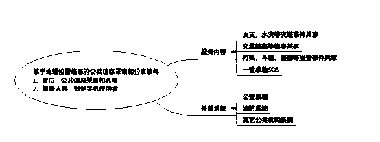
[0024] figure 1 The system architecture diagram of the present invention shown. Including the service concept of the present invention, the population covered, the service mode and service content, etc.

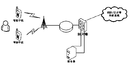
[0025] figure 2 The network topology diagram of the present invention is shown. Including server side, mobile terminal and external system. Mobile terminals include smart phones, etc.; external systems include systems of public security and fire departments.

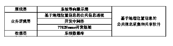
[0026] image 3 Show the system design architecture of public information collection and sharing software based on geographic location information; the software system of the present invention is based on B / S architecture and adopts J2EE technology; the whole system is divided into three layers: presentation layer, business logic processing layer, and data layer.

[0027] Presentation l...


PUM


Abstract

The invention discloses a common information acquisition and sharing software based on geographical position information. The common information acquisition and sharing software is characterized in that when a user opens the software on a mobile terminal, the software can be used without registration and login, so that the software can be used efficiently and rapidly. The interface of the software only includes an icon identifying the fire alarm, an icon identifying traffic, a public security icon identifying 110, a help icon identifying SOS and a map. The current geographical position information is automatically obtained by the mobile terminal, and the user only needs to click the corresponding icon when in need of sharing the common information of the current position. By adopting an LBS technology, the position information can be timely, efficiently and accurately obtained when the user is not familiar with the accurate position or the user fails to describe the position because of tension and the like, so that an effective guarantee is provided for the emergency of public security events.

Description

technical field [0001] The invention relates to information collection and sharing, in particular to public information collection and sharing based on geographic location positioning technology. Background technique [0002] With the rapid development of our country's national economy, the scale of cities continues to expand, including the substantial increase in urban population and the expansion of urban areas. [0003] The current information sharing is mostly focused on where I am, what I want to do, and what I want to do. The focus is on publishing individual needs, rather than public information that everyone pays attention to; even if there is active sharing of effective information, it is through the radio Such as traditional media to obtain, but the coverage of traditional media is limited; the way of information dissemination is not simple, cumbersome, and even full of invalid information. [0004] According to the "30th Statistical Report on Internet Development...

Claims


Application Information

Patent Timeline
Patent Type & Authority Applications(China)
IPC IPC(8): H04L29/08H04M1/725H04M11/04H04W4/02
Inventor 邱浩霖周洋
Owner 广州七七八二信息科技有限公司
Why Eureka
Try Eureka