Gravitational middle layer density spectrum gaining method

An intermediate layer and density technology, applied in the field of geophysical exploration, can solve the problem of the difficulty of accurately understanding the density characteristics at the measuring point, the inability to establish the relationship between the intermediate layer density and the formation, and the inability to effectively eliminate the false anomalies of gravity anomalies And other issues

Active Publication Date: 2014-01-29
BC P INC CHINA NAT PETROLEUM CORP +1
View PDF4 Cites 6 Cited by
  • Summary
  • Abstract
  • Description
  • Claims
  • Application Information

AI Technical Summary

Problems solved by technology

This method only involves the residual density value at the end of the calculation process, and cannot establish the relationship between the density of the intermediate layer and the stratum well. The display of the density value of the intermediate layer is not intuitive, and it is difficult to accurately understand the density characteristics at each measuring point.
[0006] In 2006, Qin Zhangjian and others disclosed an application method of digital image technology in gravity anomaly terrain correction, and proposed a digital image application technology, which is calculated based on the known formation density distribution. In the work, the real formation density and its distribution are unknown quantities, and it is difficult for this technology to meet the needs of high-precision gravity data processing in practical applications
[0007] To sum up, the currently used high-precision gravity exploration data processing methods are complicated, unintuitive, and inefficient, and cannot effectively eliminate the false anomalies related to terrain in gravity anomalies

Method used


Image

  • Gravitational middle layer density spectrum gaining method
  • Gravitational middle layer density spectrum gaining method
  • Gravitational middle layer density spectrum gaining method

Examples


specific Embodiment approach

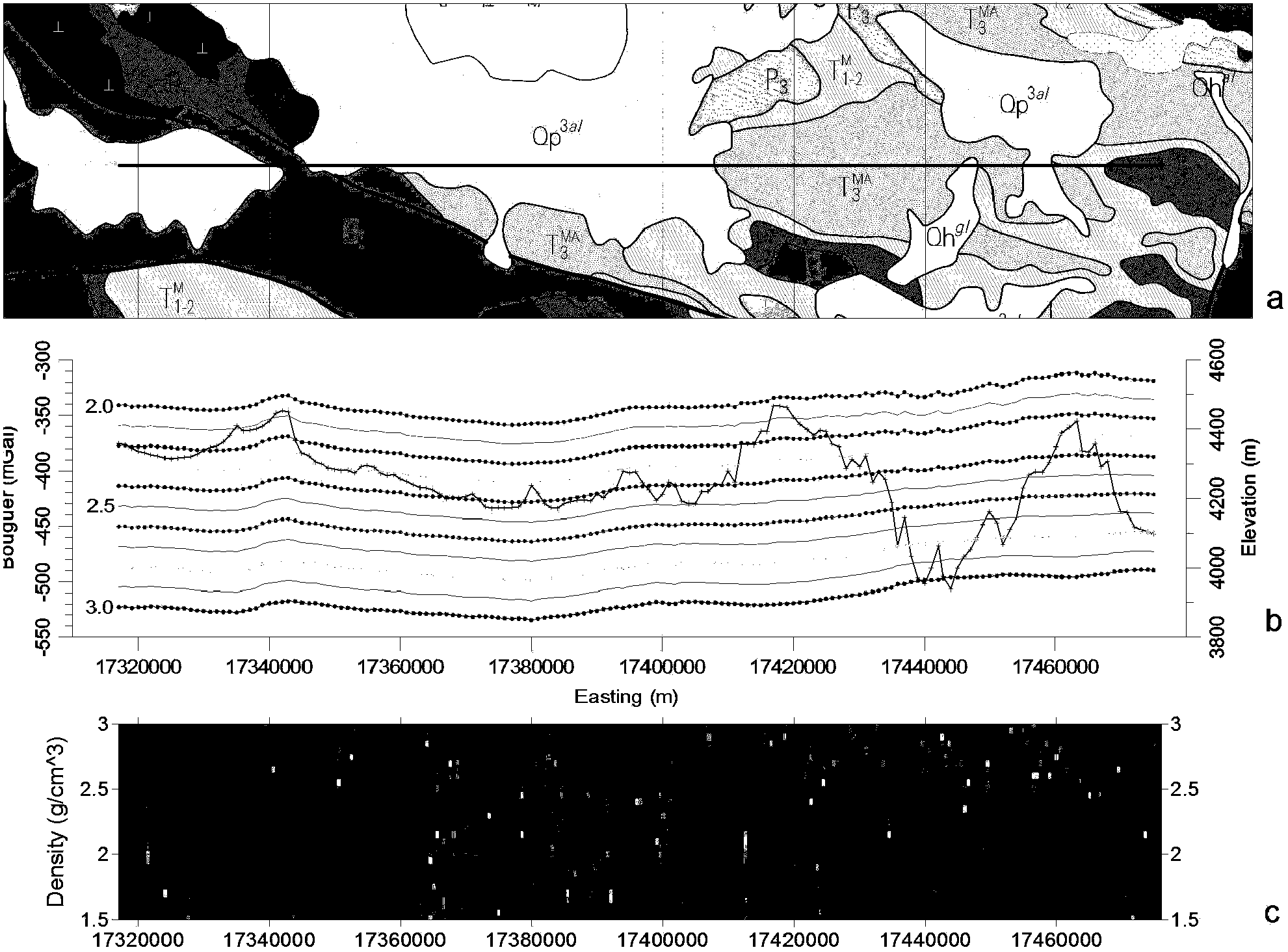
[0033] 1) The absolute gravity value and coordinate elevation of each measuring point in the survey area were obtained through gravity collection, and then an east-west survey line in the middle of the work area was selected to calculate the Bouguer gravity anomaly data with different densities;

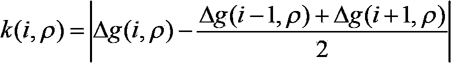
[0034] The calculation described in step 1) includes: calculating the normal gravity value g according to the plane coordinates of the measuring points 0 ; Calculate the Bouguer correction value Δg according to the elevation of the measuring point and the density of the intermediate layer b ; Calculate the terrain correction value Δg according to the terrain data TC ; The Bouguer gravity anomaly of the measuring point adopts the formula Δg=g-g 0 +Δg b +Δg TC Calculation, where g is the absolute gravity value of the measured measuring point.

[0035] The different densities mentioned in step 1) refer to the density range of 1.5g / cm 3 ~3.0g / cm 3 , the value step is 0.02g / cm 3 Ea...


PUM


Abstract

The invention relates to processing on geophysical exploration and gravity prospecting data, and provides a gravitational middle layer density spectrum gaining method. The gravitational middle layer density spectrum gaining method comprises the following steps of acquiring absolute gravity values and coordinate elevations of various measuring points on a measuring line by using gravity; calculating abnormal variation between the bouguer gravity anomaly value of each of points with different densities and the bouguer gravity anomaly average value of a former point and a latter point which are adjacent to the point, and forming gravitational middle layer density spectrum gridding data; plotting from large to small by using different colors or from dark to light according to the gravitational middle layer density spectrum gridding data; and enabling the minimum value of the densities to be displayed obviously so as to obtain a gravitational middle layer density spectrum. The density value acquired in a region with the wavy terrain is consistent to the result obtained by using a density profile method; compared with the density profile method, the gravitational middle layer density spectrum gaining method has higher resolution capability, and can be used for identifying density values of a region with a certain area of exposed stratum; identification on the density value of a middle layer is visual; the identification method is simple; and the identification result is reliable.

Description

technical field [0001] The invention relates to geophysical prospecting technology, which belongs to a gravity prospecting data processing method, in particular to a method for obtaining a density spectrum of a gravity middle layer. Background technique [0002] In seismic exploration, velocity is one of the most important parameters for data processing and interpretation, and velocity spectrum provides velocity information for seismic data processing. Similarly, in the processing of gravity data in geophysical exploration, the density of the mesosphere is the most basic and important parameter in the processing of gravity data, but in actual work, it is difficult to obtain more accurate data of the density of the mesosphere. In the processing of gravity exploration data, the calculation of Bouguer gravity anomaly requires normal field correction, height correction, mesolayer correction and terrain correction, among which mesosphere correction and terrain correction are rela...

Claims


Application Information

Patent Timeline
Patent Type & Authority Applications(China)
IPC IPC(8): G01V7/06
Inventor 杨战军
Owner BC P INC CHINA NAT PETROLEUM CORP
Why Eureka
Try Eureka