A Calculation Method of Gravity Mesosphere Density Spectrum

An intermediate layer and density technology, applied in the field of geophysical exploration, can solve the problems of low efficiency, unintuitive reflection, and meet the needs of high-precision gravity data processing.

Active Publication Date: 2016-11-30
BC P INC CHINA NAT PETROLEUM CORP +1
View PDF4 Cites 0 Cited by
  • Summary
  • Abstract
  • Description
  • Claims
  • Application Information

AI Technical Summary

Problems solved by technology

This method only involves the residual density value at the end of the calculation process, and cannot establish the relationship between the density of the intermediate layer and the stratum well. The display of the density value of the intermediate layer is not intuitive, and it is difficult to accurately understand the density characteristics at each measuring point.
[0006] In 2006, Qin Zhangjian and others disclosed an application method of digital image technology in gravity anomaly terrain correction, and proposed a digital image application technology, which is calculated based on the known formation density distribution. In the work, the real formation density and its distribution are unknown quantities, and it is difficult for this technology to meet the needs of high-precision gravity data processing in practical applications
[0007] To sum up, the currently used high-precision gravity exploration data processing methods are complicated, unintuitive, and inefficient, and cannot effectively eliminate the false anomalies related to terrain in gravity anomalies

Method used


Image

  • A Calculation Method of Gravity Mesosphere Density Spectrum
  • A Calculation Method of Gravity Mesosphere Density Spectrum
  • A Calculation Method of Gravity Mesosphere Density Spectrum

Examples


specific Embodiment approach

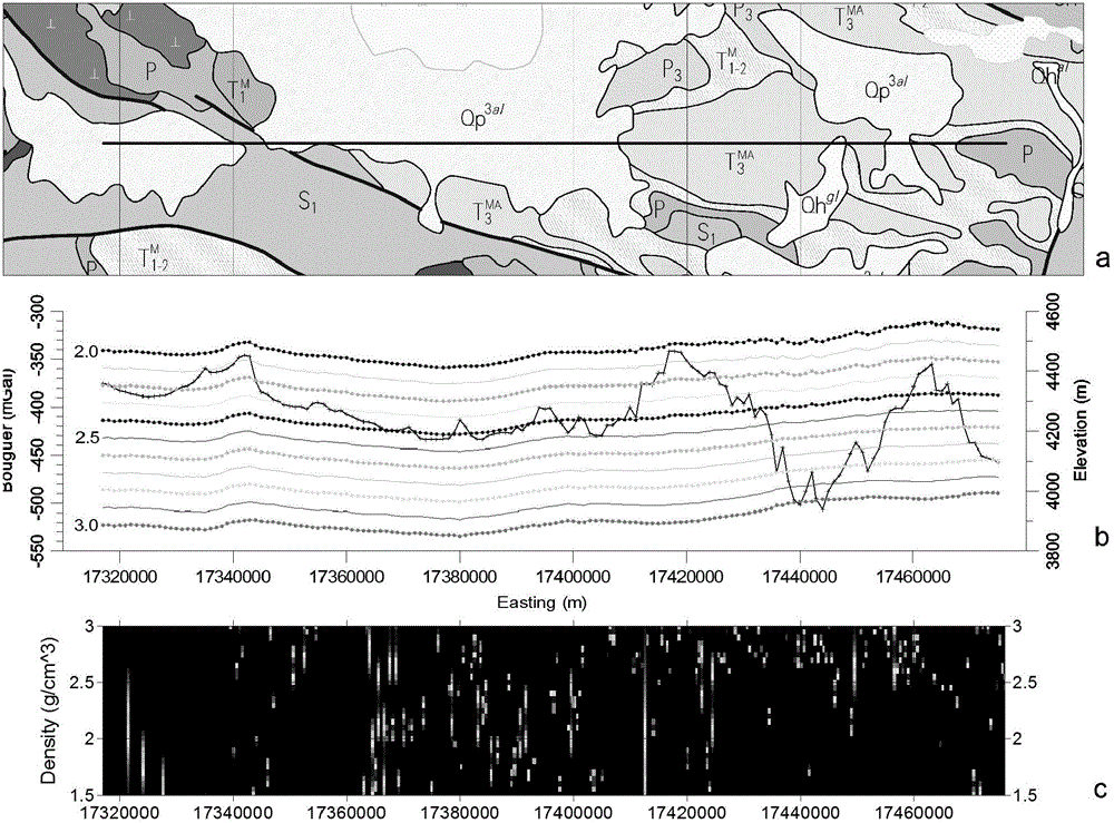
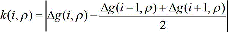
[0033] 1) Obtain the absolute gravity value and coordinate elevation of each measuring point in the survey area through gravity collection, then select an east-west survey line in the middle of the work area, and calculate the Bouguer gravity anomaly data with different densities;

[0034] Step 1) The calculation includes: calculating the normal gravity value g according to the plane coordinates of the measuring point 0 ; Calculate the Bouguer correction value Δg according to the elevation of the measuring point and the density of the intermediate layer b ;Calculate the terrain correction value Δg according to the terrain data TC ; The Bouguer gravity anomaly at the measuring point adopts the formula Δg=g-g 0 +Δg b +Δg TC Calculation, where g is the absolute gravity value of the measured point.

[0035] Step 1) The different density mentioned refers to the density range of 1.5g / cm 3 ~3.0g / cm 3 , The value step is 0.02g / cm 3 的 Each density value ρ.

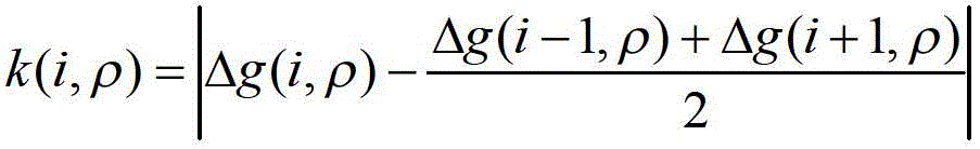
[0036] 2) Calculate the abnormal de...


PUM


Abstract

The invention relates to the processing of gravity exploration data in geophysical exploration, and is a method for calculating the density spectrum of the gravity middle layer. Obtain the absolute gravity value and coordinate elevation of each measuring point on the survey line through gravity collection, and calculate the abnormal deviation between the Bouguer gravity anomaly value of each point of different density and the average value of the Bouguer gravity anomaly of two adjacent points before and after, forming the gravity middle layer density Spectrum grid data, according to the density spectrum grid data of the gravitational middle layer, use color from large to small or from dark to light to draw, so that the minimum value under each density is clearly displayed, and the density spectrum of the gravitational middle layer is obtained. The density value obtained by the present invention is consistent with the result of the density profile method in areas with large terrain fluctuations, and has higher resolution than the density profile method, and can identify the density value of the stratum exposure area with a certain area, while the density value of the exposed area of ​​the formation can be identified. The identification of the density value of the middle layer is more intuitive, the identification method is simpler, and the identification result is more reliable.

Description

Technical field [0001] The invention relates to geophysical prospecting technology, belonging to a method for processing gravity prospecting data, in particular to a method for obtaining a density spectrum of a gravity middle layer. Background technique [0002] In seismic exploration, velocity is one of the most important parameters for data processing and interpretation, and velocity spectrum provides velocity information for seismic data processing. Similarly, in the processing of gravity data for geophysical exploration, the density of the middle layer is the most basic and most important parameter for gravity data processing, but in actual work, it is difficult to obtain more accurate data about the density of the middle layer. In the processing of gravity exploration data, the calculation of Bouguer gravity anomaly requires normal field correction, height correction, intermediate layer correction, and topographic correction. The intermediate layer correction and terrain cor...

Claims


Application Information

Patent Timeline
Patent Type & Authority Patents(China)
IPC IPC(8): G01V7/06
Inventor 杨战军
Owner BC P INC CHINA NAT PETROLEUM CORP
Why Eureka
Try Eureka