System and method for measuring line sag height based on unmanned aerial vehicle

A measurement line and measurement system technology, applied in the field of aerial measurement, can solve the problems of poor measurement accuracy, use restrictions, measurement difficulties, etc., and achieve the effects of labor-saving measurement efficiency and strong site adaptability

Inactive Publication Date: 2014-02-19
STATE GRID CORP OF CHINA +1
View PDF4 Cites 21 Cited by
  • Summary
  • Abstract
  • Description
  • Claims
  • Application Information

AI Technical Summary

Problems solved by technology

[0003] After years of development using drones to measure target heights, it has been able to meet the requirements of large-scale projects with low measurement accuracy requirements; however, it is used for projects in difficult-to-pass or dangerous areas, such as substations and places with many line towers. It is subject to certain restrictions, resulting in difficult measurement and poor measurement accuracy.

Method used


Image

  • System and method for measuring line sag height based on unmanned aerial vehicle
  • System and method for measuring line sag height based on unmanned aerial vehicle
  • System and method for measuring line sag height based on unmanned aerial vehicle

Examples


Embodiment 1

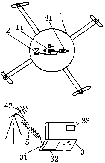
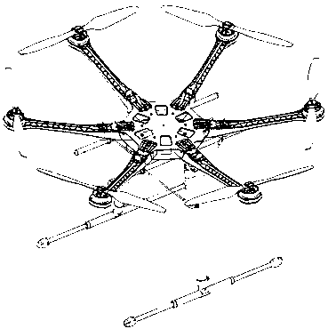
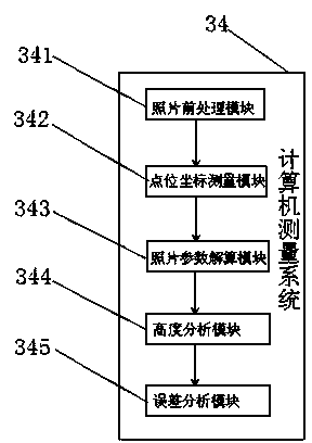
[0024] as attached figure 1 , attached figure 2 , attached image 3 As shown, the present embodiment is based on a system for measuring the sag height of a line by an unmanned aerial vehicle, including a rotor unmanned aerial vehicle 1 with a GPS positioning device, a digital camera 2, a microwave transmitter 41, a ground control station 3, a microwave receiving antenna 42, Data line 5 and computer measurement system 34, digital camera 2 and microwave launcher 41 are installed on the described rotor drone 1, and described digital camera 2 and microwave launcher 41 are connected by the flight control panel 11 of drone, computer The measurement system 34 is installed on the ground control station 3 , and the computer serial port 31 on the ground control station 3 is connected to the microwave receiving antenna 42 through the data line 5 . The flight control board 11 is an electronic integrated chip, which can realize functions such as automatic flight of the drone and data c...


PUM


Abstract

The invention relates to the technical field of aerial survey and especially relates to a system and a method for measuring line sag height based on an unmanned aerial vehicle. The system for measuring line sag height based on an unmanned aerial vehicle comprises a rotor unmanned aerial vehicle, a digital camera, a ground control station, a microwave emitter, a microwave reception antenna, a data line and a computer measurement system. The rotor unmanned aerial vehicle is provided with the digital camera and the microwave emitter. The digital camera is connected to the microwave emitter by a flying control panel of the rotor unmanned aerial vehicle. The computer measurement system is installed in the ground control station. A computer serial interface of the ground control station is connected to the microwave reception antenna by the data line. The rotor unmanned aerial vehicle does not need a special-purpose rising-landing runway, has strong place adaptability and is especially suitable for height measurement on engineering in an area having complex landform conditions. The system saves time and labor and has high measurement efficiency. Through use of the rotor unmanned aerial vehicle, safety is high and the damage on people is avoided.

Description

technical field [0001] The invention relates to the technical field of aerial surveying, in particular to a system and method for measuring line sag height based on a rotor drone. Background technique [0002] Unmanned helicopters are low in cost, high in cost-efficiency, and easy to use. They have broad development prospects in civilian and military fields. Unmanned helicopters have strong weather adaptability and can fly under conditions that are not suitable for general flight. They are widely used in aerial photography , high-altitude stringing, line inspection, etc. [0003] After years of development using drones to measure target heights, it has been able to meet the requirements of large-scale projects with low measurement accuracy requirements; however, it is used for projects in difficult-to-pass or dangerous areas, such as substations and places with many line towers. It is subject to certain restrictions, resulting in difficult measurement and poor measurement a...

Claims


Application Information

Patent Timeline
Patent Type & Authority Applications(China)
IPC IPC(8): G01C11/00
CPCG01C11/00G01B11/02
Inventor 李享杜毅杨蔚范强杨颖锐赖宗林
Owner STATE GRID CORP OF CHINA
Why Eureka
Try Eureka