A method for displaying real scene space by navigation map

A navigation map, a real technology, applied in the field of navigation, can solve problems such as excessive raw data, achieve the effect of improving efficiency, image quality and process, and improving experience

Active Publication Date: 2016-09-07
SHENYANG MXNAVI CO LTD
View PDF3 Cites 0 Cited by
  • Summary
  • Abstract
  • Description
  • Claims
  • Application Information

AI Technical Summary

Problems solved by technology

[0006] The present invention provides a method for displaying a real scene space on a navigation map, which is characterized in that: in the method for displaying a real scene space on a navigation map, the data storage and processing method is as follows, and the data part is input from the outside, in order to solve the original The problem of excessive data volume requires data compression after data entry. The basic idea of ​​the solution proposed here is to reorganize and sort the original data, and it is necessary to ensure that the data is not damaged

Method used


Image

  • A method for displaying real scene space by navigation map
  • A method for displaying real scene space by navigation map
  • A method for displaying real scene space by navigation map

Examples


Embodiment 1

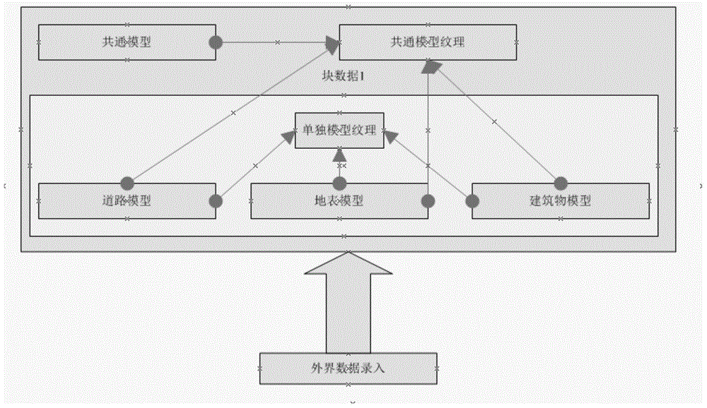
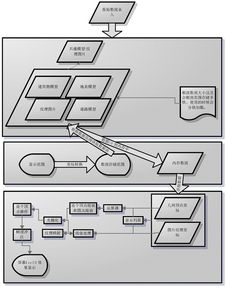
[0019] This embodiment provides a method for displaying a real scene space on a navigation map, which is characterized in that: in the method for displaying a real scene space on a navigation map, the data storage and processing methods are as follows, and the data parts are all entered from the outside. The problem of excessive raw data requires data compression after data entry. The basic idea of ​​the solution proposed here is to reorganize and sort the raw data and ensure that the data is not damaged. The data mainly consists of two parts: the object model and the model texture;

[0020] The object model is divided into two parts, one part is a separate model without commonality, such as road model, surface model, and building model. Part of it is a common model with commonality, such as: street lamps, guardrails, etc. In the process of data storage, the common model is put forward into one copy, and the individual models remain independent, so that repeated common models...


PUM


Abstract

A method for displaying the real scene space on a navigation map. The data storage and processing method is as follows. The data part is entered from the outside. In order to solve the problem of excessive original data, data compression is required after data entry. The proposed method is here The basic idea of ​​the scheme is to reorganize and sort the original data, and it is necessary to ensure that the data is not damaged; the data mainly consists of two parts: the object model and the model texture; the object model is divided into two parts, one part is a separate model with no commonality, and the other part is There is a common model with commonality; the original vertex coordinates and texture coordinates are all stored by floating point numbers. The invention has the advantages of solving the problem of limited capacity of the storage medium by compressing the data, and improving the utilization rate of the storage medium. It improves the efficiency of the program in data reading, and is especially effective in guiding and prompting complex intersections. It is an indispensable real-scene display technology for future metropolitan navigation.

Description

technical field [0001] The invention relates to the field of navigation, in particular to a method for displaying a real real scene space on a navigation map. Background technique [0002] With the rise of the automotive electronics industry, car navigation systems have begun to come into people's sight. Car navigation system is a complex that provides drivers with services such as electronic maps, vehicle positioning, real-time voice guidance, and real-time screen guidance based on embedded hardware, global GPS positioning, and geographic information data. Although automotive electronic navigation products have been developed for decades, all areas of navigation have made unprecedented progress, such as the improvement of GPS accuracy, the rise of voice navigation, the application of positioning and locking technology, the application of dual-page technology, etc. , but in terms of map display, it is still limited to the basic drawing of points, lines, and planes, which is...

Claims


Application Information

Patent Timeline
Patent Type & Authority Patents(China)
IPC IPC(8): G06T17/05
Inventor 郭瑞瑞王海世赖克朱小莹
Owner SHENYANG MXNAVI CO LTD
Why Eureka
Try Eureka