Method and device for processing cartographic data for determining energy-saving routes

A technology of map data, geographic location, applied in the direction of measuring devices, control devices, transportation and packaging, etc.

Active Publication Date: 2014-03-12
ELEKTROBIT AUTOMOTIVE
View PDF9 Cites 19 Cited by
  • Summary
  • Abstract
  • Description
  • Claims
  • Application Information

AI Technical Summary

Problems solved by technology

[0007] Known methods for determining optimal consumption routes have in common that they are all based on section-reduced consumption models and therefore often only give rough predictions about energy-saving routes

Method used


Image

  • Method and device for processing cartographic data for determining energy-saving routes
  • Method and device for processing cartographic data for determining energy-saving routes
  • Method and device for processing cartographic data for determining energy-saving routes

Examples


Embodiment Construction

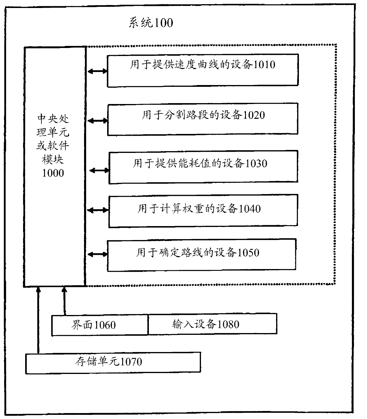
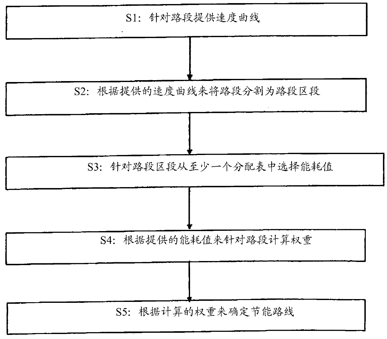
[0032] figure 1 An embodiment of the system 100 is shown in the form of a block diagram. The system 100 is used to process map data for the purpose of determining an energy-saving route between two geographic locations. The map data contains the road segments and route nodes of the actual road network. . The system can be part of a fixed embedded navigation device, personal digital processing (PDA), smart phone, or personal navigation device (PND). Although the embodiment is described in combination with a road network, the present disclosure can be generally applied in combination with a traffic route network (for example, it is also used in a railway network).

[0033] The system 100 includes a core function module 1000, a device 1010, a device 1020, a device 1030, a device 1040, a device 1050, and at least one interface 1060. The core function module 1000 is a central processing unit (CPU), a microprocessor, or in the form of a software module, The device 1010 is used to prov...


PUM


Abstract

A technique is described for determining an energy-saving route between two geographic positions on the basis of predefined cartographic data, the cartographic data describing a real traffic route network in the form of route segments and route nodes. A method aspect comprises the steps of subdividing the route segments provided for a route calculation into route segment portions that each have a predefined speed profile, providing an energy consumption value to be expected for each of the route segment portions, on the basis of the respectively assigned speed profile, and calculating weights for the respective route segments on the basis of the energy consumption values provided for the route segment portions, wherein the weights can be used to determine the energy-saving route in the context of the route calculation.

Description

Technical field [0001] This application generally relates to the determination of energy-saving routes. In particular, it relates to a technology for determining energy-saving routes based on appropriately processed map data. Background technique [0002] Methods for calculating a route between two or more predetermined geographic locations (for example, via the input of a starting point, a destination point, and / or an intermediate destination) are well known. In this case, the calculated route is usually determined as a graph of nodes and road segments, where intersections or road nodes are usually equivalent to nodes, and adjacent intersections or sections between road nodes are equivalent to road segments. [0003] Links and nodes can be more fully described by additional attributes, such as the length of each segment, segment type, maximum allowable driving speed, driving direction, intersection type, and so on. The link algorithm can use these attributes to determine the wei...

Claims


Application Information

Patent Timeline
Patent Type & Authority Applications(China)
IPC IPC(8): G01C21/34
CPCG01C21/3469B60L2260/54B60W2540/30G01C21/20G01C21/3484G01C21/3492G01C21/3617G08G1/096838G08G1/096844
Inventor 约尔格·沃尔夫
Owner ELEKTROBIT AUTOMOTIVE
Why Eureka
Try Eureka