Emergency knowledge base maintaining system based on geographic information technology and achievement method

A geographic information technology and maintenance system technology, applied in geographic information databases, database design/maintenance, special data processing applications, etc., can solve the problems of inconvenient confirmation and maintenance of knowledge information, and the inability of knowledge information to be associated with geographic location information. , to achieve the effect of improving application value, enhancing maintenance, and simplifying modification

Inactive Publication Date: 2014-03-12
CLOUD COMPUTING CENT CHINESE ACADEMY OF SCI
View PDF4 Cites 14 Cited by
  • Summary
  • Abstract
  • Description
  • Claims
  • Application Information

AI Technical Summary

Problems solved by technology

[0006] One of the technical problems solved by the present invention is to provide an emergency knowledge base maintenance system based on geographic information technology, which solves the problem that knowledge information in the current emergency knowledge base cannot be associated with geographic location information, and the confirmation and maintenance of automatically associated knowledge information is inconvenient, etc. question
[0007] The second technical problem solved by the present invention is to provide a method for realizing an emergency knowledge base maintenance system based on geographic information technology, which solves the problem that the knowledge information in the current emergency knowledge base cannot be associated with the geographic location information, and the automatically associated knowledge information cannot be confirmed and maintained. Convenience and other issues

Method used


Image

  • Emergency knowledge base maintaining system based on geographic information technology and achievement method

Examples


Embodiment Construction

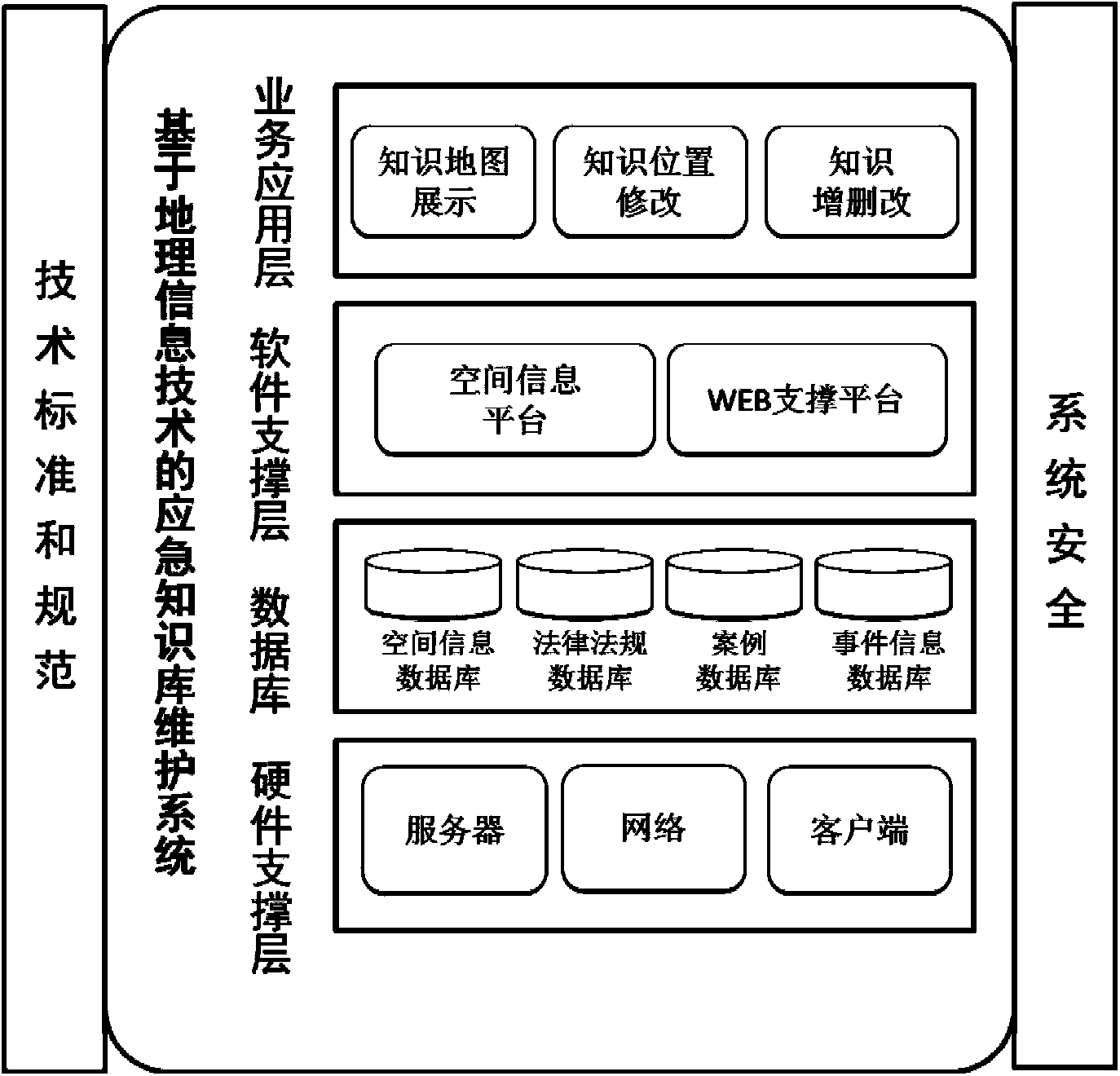
[0058] As shown in the accompanying drawings, the overall architecture of the emergency knowledge base maintenance system based on geographic information technology in the present invention is divided into four layers, which are business application layer, software support layer, database layer and hardware support layer.

[0059] Business application layer: including knowledge information display, knowledge geographical location information modification and knowledge addition, deletion and modification interface. Knowledge information is displayed in the form of list and map mark respectively. The modification of knowledge geographic location information includes viewing of knowledge information details and modifying knowledge geographic location information by dragging the mouse. The addition, deletion, and modification of knowledge information complete the basic operations of knowledge base maintenance, that is, the addition, editing, and deletion of new knowledge.

[0060...


PUM


Abstract

The invention relates to the technical field of comprehensive emergency management, in particular to an emergency knowledge base maintaining system based on the geographic information technology and an achievement method. Address information in an address encoded library serves as key words, knowledge information corresponding to an emergency knowledge base are retrieved, retrieval results are scored according to weighted values, and the knowledge information and geographic position information are automatically correlated. The emergency knowledge base maintaining system based on the geographic information technology and the achievement method have the advantages that the longitude and the latitude of the knowledge information are calculated according to the automatically-correlated geographic position information and the longitude and the latitude are displayed in a map; the longitude and the latitude of the knowledge information are deassigned by dragging a knowledge information label; the system can automatically calculate the corresponding address code according to the new longitude and the new latitude so as to achieve relocation of the geographic position information of the knowledge information. The emergency knowledge base maintaining system based on the geographic information technology and the achievement method solve the problems of correlation of the knowledge information and the geographic position information of the emergency knowledge base and the like and can be applied to an emergency knowledge base maintaining system.

Description

technical field [0001] The invention relates to the technical field of comprehensive emergency management, in particular to an emergency knowledge base maintenance system and an implementation method based on geographic information technology. Background technique [0002] With the development of social economy, the complexity of emergencies also arises. One of its manifestations is the frequent occurrence and diversification of public emergencies. Natural disasters, accident disasters, public health incidents, social security incidents and other emergencies in real life not only pose a huge threat to normal human activities, but also seriously affect the normal operation of the entire social and economic system. The timeliness of emergency handling is very high, and the processing involves a large amount of data. An emergency decision-making system is needed to efficiently analyze the data of emergencies and quickly form an optimal disposal plan. [0003] The decision-maki...

Claims


Application Information

Patent Timeline
Patent Type & Authority Applications(China)
IPC IPC(8): G06F17/30
CPCG06F16/21G06F16/29
Inventor 韩宏哲李新安李智勇赵锋伟温志强
Owner CLOUD COMPUTING CENT CHINESE ACADEMY OF SCI
Why Eureka
Try Eureka