On-orbit geometric calibration method of optical remote sensing camera

A geometric calibration and optical remote sensing technology, applied in image data processing, measuring devices, instruments, etc., can solve problems such as inability to calibrate physical parameters, calibration accuracy cannot meet predetermined requirements, and technical details are not disclosed

Active Publication Date: 2014-03-26
CHINA CENT FOR RESOURCES SATELLITE DATA & APPL
View PDF3 Cites 54 Cited by
  • Summary
  • Abstract
  • Description
  • Claims
  • Application Information

AI Technical Summary

Problems solved by technology

[0003] Judging from the current published articles and public information, in the field of domestic remote sensing camera inspection, in terms of geometric calibration of optical remote sensing cameras, the main research work focuses on the calibration of technical parameters of ground and aerial photogrammetry cameras, and most of them focus on the calibration of traditional frames. In-depth research on the field camera; and a small amount of research on the on-orbit geometric calibration of aerospace line array cameras is to use a mathematical model to fit the image distortion caused

Method used


Image

  • On-orbit geometric calibration method of optical remote sensing camera
  • On-orbit geometric calibration method of optical remote sensing camera
  • On-orbit geometric calibration method of optical remote sensing camera

Examples


Embodiment

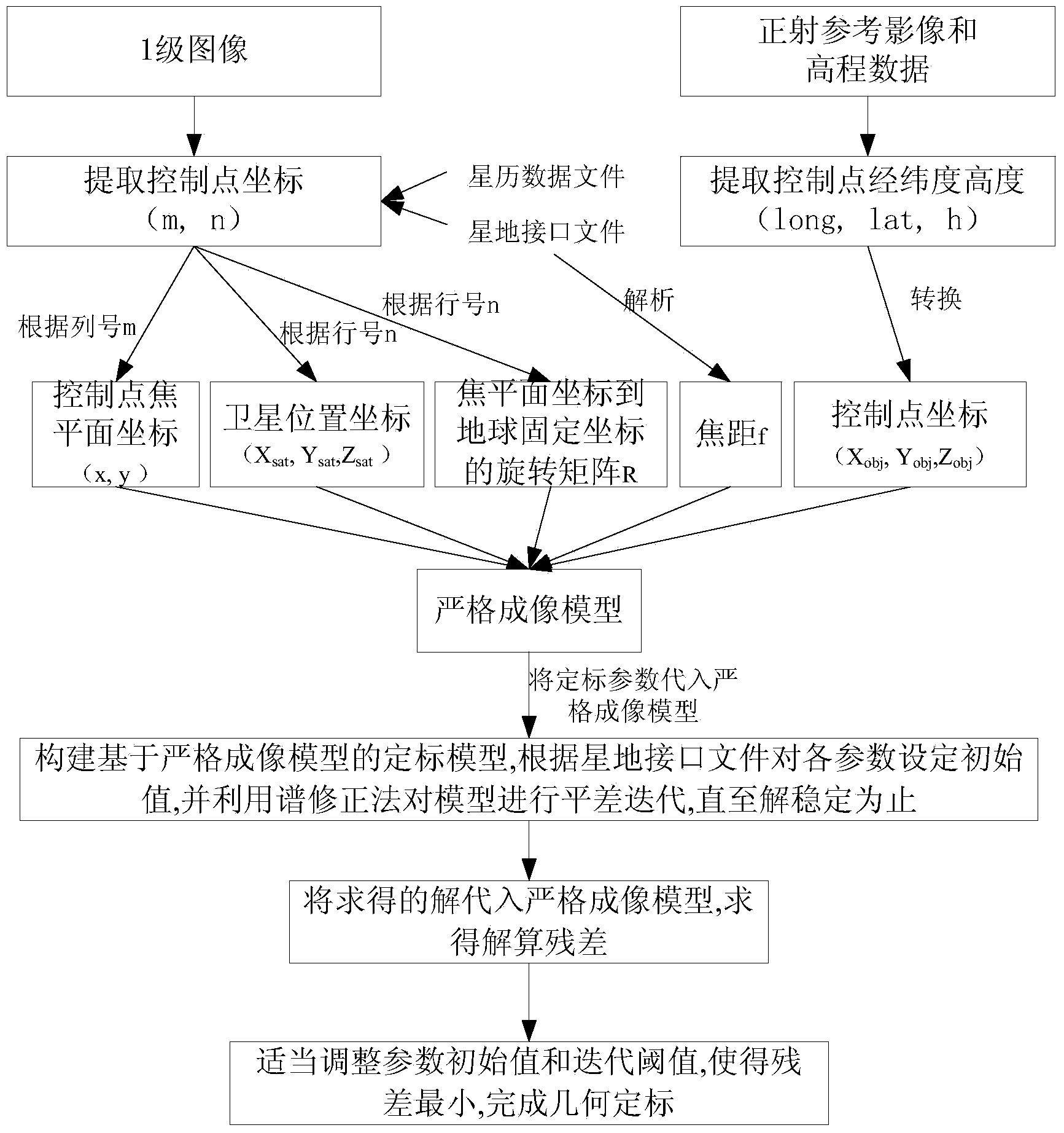
[0079] The calibration model is tested by using 02C multispectral data of domestic resources. A remote sensing image covering the Beijing area on September 15, 2012 was selected as the image to be corrected. The size of the camera CCD pixel was 13 μm, corresponding to 10 m on the ground. The orthophoto image produced by the China Resources Satellite Application Center is used as the reference image, and the elevation data is SRTM3. There are 33 control points in total, the plane accuracy is 10 meters, and the elevation accuracy is about 15 meters.

[0080] The distortion error before fitting is very obvious, see Figure 5a , 5b , 6a, 6b, the direction of the arrow indicates the direction of the distortion, and the length of the arrow indicates the magnitude of the distortion. After calibration by this method, the calibration results of each parameter are shown in Table 1, and the calibration residuals are shown in Table 2. It can be seen from the calibration results that t...


PUM


Abstract

An on-orbit geometric calibration method of an optical remote sensing camera aims at a domestic satellite platform and load design characteristics to build a strict imaging model, and uses an internal and external orientation element combination modeling method for geometric calibration treatment. The method is based on the strict imaging model for the geometric calibration treatment, and model parameters have clear physical meanings; 2) simultaneous decoupling of internal and external orientation elements can be realized by internal and external orientation element combination modeling; 3) the model can be used for a multiple linear array camera and multi-camera combination calibration, and has a strong universality; 4) according to the method, various factors causing image distortion in an imaging process can be fully considered, and high precision can be achieved.

Description

technical field [0001] The invention belongs to the field of on-orbit geometric calibration of domestic remote sensing satellites, and is suitable for linear array push-broom optical CCD remote sensing cameras. Background technique [0002] With the development of my country's aerospace technology, the spatial resolution of domestic remote sensing satellites has gradually improved, and the actual positioning accuracy of remote sensing images has become an important inspection index. The linear push-broom optical remote sensing camera is a main optical remote sensing satellite payload. The on-orbit calibration of its internal and external azimuth elements can reduce image distortion and improve the accuracy of image-to-ground positioning. [0003] Judging from the current published articles and public information, in the field of domestic remote sensing camera inspection and comparison, in the geometric calibration of optical remote sensing cameras, the main research work foc...

Claims


Application Information

Patent Timeline
IPC IPC(8): G01C25/00
CPCG06T7/80
Inventor 兰穹穹
Owner CHINA CENT FOR RESOURCES SATELLITE DATA & APPL
Why Eureka
Try Eureka