Unlock instant, AI-driven research and patent intelligence for your innovation.

High-resolution radio altimeter with positioning function and method for measuring position

A radio altimeter, high-resolution technology, applied in radio wave measurement systems, radio wave reflection/reradiation, measurement devices, etc., can solve the problems of unsuitable installation and use of small and medium-sized aircraft, high cost, and large volume

Active Publication Date: 2014-04-09
SHAANXI CHANGLING ELECTRONICS TECH
View PDF4 Cites 14 Cited by
  • Summary
  • Abstract
  • Description
  • Claims
  • Application Information

AI Technical Summary

Problems solved by technology

[0005] The above-mentioned traditional altimeters have low terrain resolution and cannot be used for positioning, while interferometric synthetic aperture radars are not suitable for installation and use of small and medium-sized aircraft due to their high cost and large size.

Method used


Image

  • High-resolution radio altimeter with positioning function and method for measuring position
  • High-resolution radio altimeter with positioning function and method for measuring position
  • High-resolution radio altimeter with positioning function and method for measuring position

Examples


Embodiment Construction

[0045] Embodiments of the present invention will be further described below with reference to the drawings and specific embodiments.

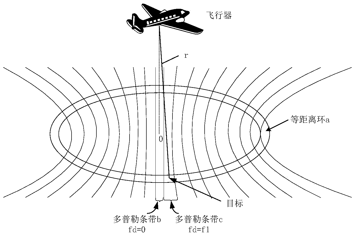
[0046] like figure 1 As shown, the range ring a of the existing altimeter echo signal is at a distance r from the aircraft, the frequency of the Doppler band b is 0, and the frequency of the Doppler band c is f1. When the present invention processes the received ground echo, the position of the range gate is set as r, and the center frequency of the strip filter is set as f1, so that the echo signal of the target can be obtained, and the target can be uniquely determined by processing the signal. Select the location of the target.

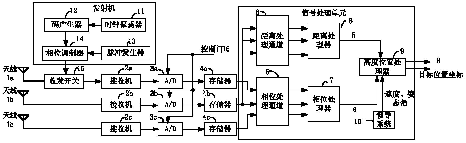
[0047] refer to figure 2 , the system of the present invention includes: three receiving antennas, three receivers, three A / D modules, three memory stores, phase processing channel 5, distance processing channel 6, phase processor 7, distance processor 8, height position Processor 9, inertial navigation system 1...


PUM


Abstract

The invention discloses a high-resolution radio altimeter with a positioning function. The high-resolution radio altimeter mainly solves the problem that an existing altimeter can only measure the height of an aircraft and cannot position the aircraft. The altimeter comprises three pairs of antennas, an emitter, three receivers, three analog-digital (A / D) converters, three storages, a distance processing channel, a distance processor, a phase processing channel, a phase processor and a height position processor. The first pair of the antennas is used for both receiving and emitting, the second and the third pairs of the antennas are used for receiving, received signals of the second pair of the antennas are processed sequentially through the distance processing channel and the distance processor to obtain a target slope distance r, the received signals of the three pairs of the antennas are sequentially processed by the phase processing channel and the phase processor to obtain a target interference angle theta, and the height position processor carries out data processing on the interference angle theta, the slope distance r and speed and posture information provided by an inertial navigation system to obtain a position coordinate (X,Y,Z) of a target and the height H of the aircraft. The high-resolution radio altimeter can measure the height of the aircraft and the position of a ground reflection point at the same time and can assist in navigation.

Description

technical field [0001] The invention belongs to the technical field of electronic instruments, in particular to a radio altimeter, which can be used to measure the height and position of aircraft carriers such as airplanes from the ground. Background technique [0002] At present, the aircraft needs navigation equipment to provide information such as the orientation, speed, and distance of the aircraft during flight for its own position positioning and track correction. Commonly used navigation systems are Doppler radar navigation systems, inertial navigation systems, satellite navigation systems, Image matching navigation system, etc. The image matching navigation system uses the terrain height sensor to match with the electronic elevation map for positioning, and can also provide terrain features under the aircraft for forward collision avoidance and terrain hazard avoidance. The image matches the altitude of the aircraft required by the navigation system and the terrain f...

Claims


Application Information

Patent Timeline
IPC IPC(8): G01S13/42G01S13/86G01S7/41
CPCG01S7/41G01S13/42G01S13/86
Inventor 范振林任进良张宝会陈娟陈晓峰常东胜
Owner SHAANXI CHANGLING ELECTRONICS TECH
Features
  • R&D
  • Intellectual Property
  • Life Sciences
  • Materials
  • Tech Scout
  • Unparalleled Data Quality
  • Higher Quality Content
  • 60% Fewer Hallucinations
Learn More