Mobile phone location based traffic mode identification method

A traffic travel and pattern recognition technology, which is applied in the field of traffic information services, can solve the problems of low recognition accuracy, insignificant decision-making effect, and large amount of computation.

Active Publication Date: 2014-05-21
GUANGZHOU INST OF GEOGRAPHY GUANGDONG ACAD OF SCI
View PDF14 Cites 85 Cited by
  • Summary
  • Abstract
  • Description
  • Claims
  • Application Information

AI Technical Summary

Problems solved by technology

There are also experts who use mobile phone location information to study traffic travel pattern recognition, but there are the following problems in the recognition method: (1) It is mainly realized by algorithms such as neural network and fuzzy recognition. 2) The accuracy of recognition is not high, and it has little effect on decision-making; (3) It is mainly research in nature, and there is still a long distance from the actual promotion and application

Method used


Image

  • Mobile phone location based traffic mode identification method
  • Mobile phone location based traffic mode identification method
  • Mobile phone location based traffic mode identification method

Examples


Embodiment

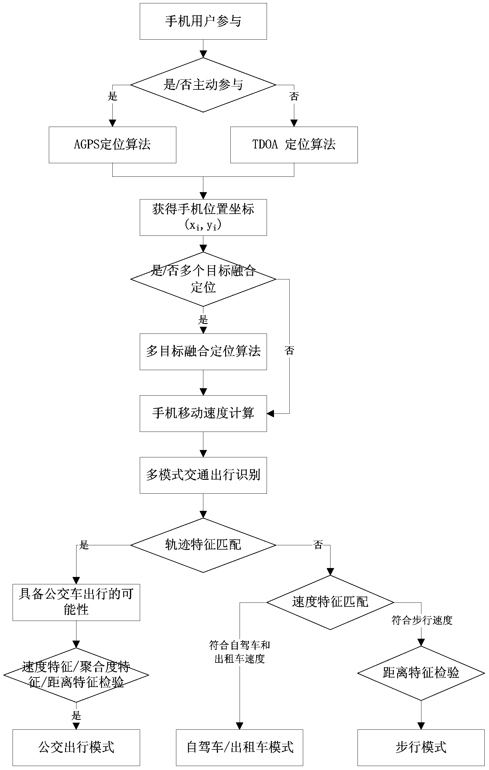
[0055] Please refer to figure 1 As shown, a mobile phone positioning traffic travel pattern recognition method which includes the following:

[0056] (1) Mobile phone positioning algorithm

[0057] According to the participation forms of mobile phone users in the travel survey, mobile phone users can be divided into active participation and passive participation. Active participation is generally in the form of recruiting mobile phone volunteers, installing data collection software on mobile phones, and actively uploading data; passive participation is carried out by using specific positioning technology through mobile positioning networks without the knowledge of mobile phone users. The collection of data, in this case, needs to protect the privacy and security of mobile phone users. Generally speaking, in the form of active participation, positioning technology based on terminal equipment (GPS, AGPS) is used; while in the form of passive participation, positioning technolo...


PUM


Abstract

The invention discloses a mobile phone location based transportation mode identification method. The mobile phone location based transportation mode identification method includes the following steps of step one, acquiring a mobile phone position coordinate through a mobile phone location algorithm; step two, determining a travel route according to the mobile phone position coordinate, and calculating a mobile phone positioning movement speed; step three, applying a multi-feature matching method to multi-mode traffic identification. According to the mobile phone location based transportation mode identification method, the multi-feature matching method for traffic mode identification is established to perform collection, analysis and spatial-temporal feature matching on mobile phone location information, so that three typical travel modes of bus travel, self-driving (or taxi) travel or walking travel can be accurately identified. By means of popularization and application of the mobile phone location based transportation mode identification method, a data support can be provided for urban traffic planning, construction and operation management, and scientific decision-making by a traffic management department is facilitated.

Description

technical field [0001] The invention relates to the technical field of traffic information services, in particular to a mobile phone positioning-based traffic travel pattern recognition method. Background technique [0002] Traffic congestion is one of the most important problems faced by urbanization. In order to solve the problem of traffic congestion, people have proposed different solutions, among which scientific planning and scheduling is considered to be an effective means to solve the problem of traffic congestion, and the basis of scientific planning and scheduling is the mastery of traffic travel information. There are many ways to collect traffic travel information. At present, the main collection methods are summarized as fixed-point collection and mobile collection. Fixed-point acquisition methods include induction coil detector acquisition, ultrasonic detector acquisition, infrared detector acquisition, microwave detector acquisition, video detector acquisitio...

Claims


Application Information

Patent Timeline
Patent Type & Authority Applications(China)
IPC IPC(8): G08G1/01
Inventor 李勇周捍东
Owner GUANGZHOU INST OF GEOGRAPHY GUANGDONG ACAD OF SCI
Why Eureka
Try Eureka