Unmanned aerial vehicle ground target real-time positioning method with automatic extraction and gathering of multiple control points

An automatic extraction, multi-control point technology, applied in the field of remote sensing image processing, can solve the problems of low positioning accuracy, difficult to meet the needs of real-time, high-precision target positioning, etc., to achieve good real-time performance, high target positioning accuracy, and conflict resolution Effect

Active Publication Date: 2014-05-28
北京北航天宇长鹰无人机科技有限公司
View PDF10 Cites 26 Cited by
  • Summary
  • Abstract
  • Description
  • Claims
  • Application Information

AI Technical Summary

Problems solved by technology

However, due to the large impact of measurement errors such as the position and attitude of the UAV, the positioning accuracy of this method is low, usually greater than 100 meters CEP
[0006] From the above comparative analysis, it can be seen that the existing target positioning method based on the UAV reconnaissance platform has a contradiction between positioning accuracy and real-time performance, and it is difficult to meet the needs of real-time and high-precision target positioning in the modern battlefield.

Method used


Image

  • Unmanned aerial vehicle ground target real-time positioning method with automatic extraction and gathering of multiple control points
  • Unmanned aerial vehicle ground target real-time positioning method with automatic extraction and gathering of multiple control points
  • Unmanned aerial vehicle ground target real-time positioning method with automatic extraction and gathering of multiple control points

Examples


Embodiment approach

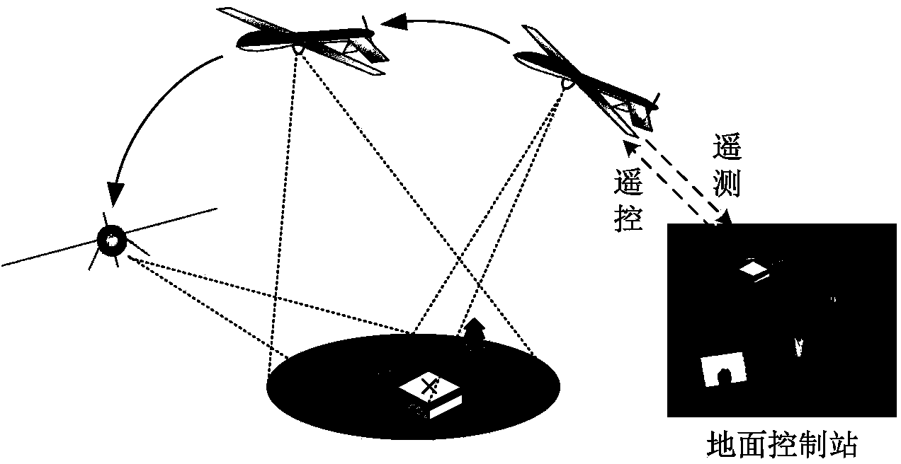
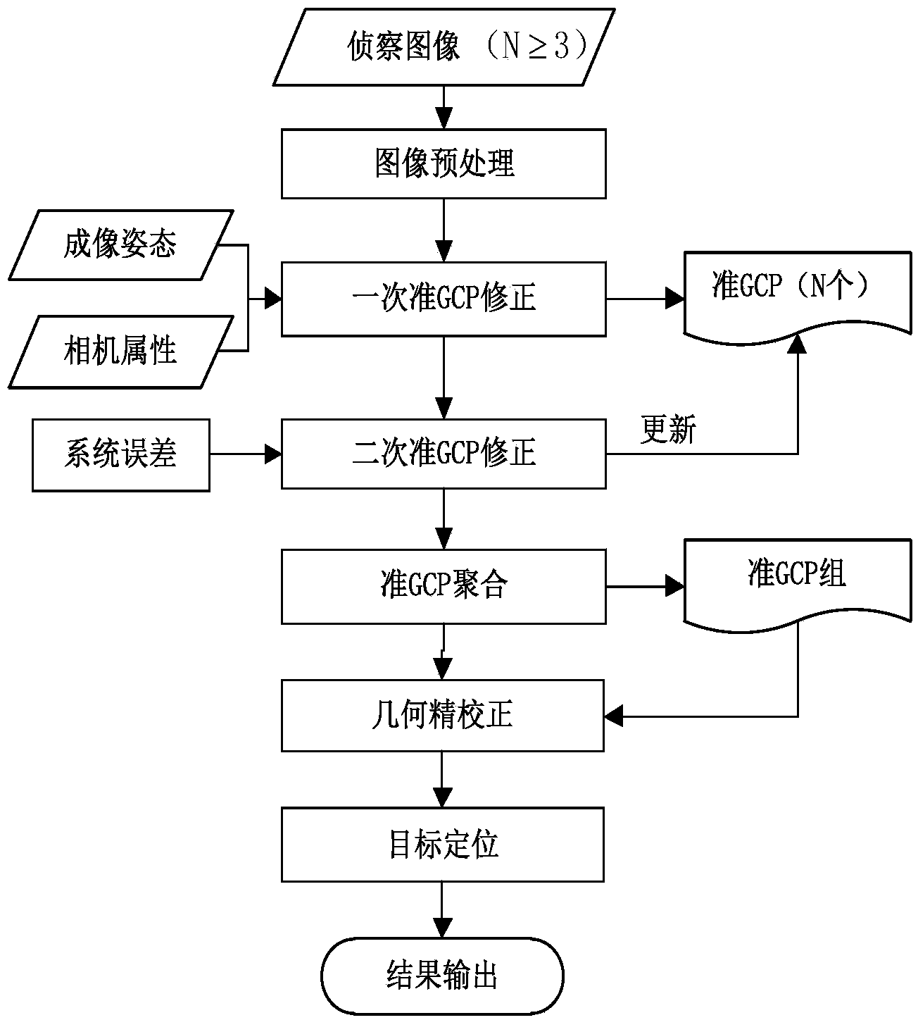
[0032] The invention is a real-time positioning method for UAV ground targets with automatic extraction and aggregation of multiple control points, through the steps of quasi-GCP extraction, correction, aggregation and geometric correction of multiple reconnaissance images acquired by the reconnaissance target and its adjacent areas , to realize the geographic positioning of the reconnaissance target. Method models such as figure 1 As shown, with the assistance of the controllers of the ground command and control station, the UAV reconnaissance equipment will download the captured target image, imaging position, attitude information and other telemetry data to the ground command and control station, and the ground image processing platform will process The reconnaissance images and related telemetry data are analyzed to obtain the target's geographic coordinates. figure 2 The overall flowchart of the method is given, and the specific implementation method includes the follow...


PUM


Abstract

The invention discloses an unmanned aerial vehicle ground target real-time positioning method with automatic extraction and gathering of multiple control points, and belongs to the unmanned aerial vehicle reconnaissance image processing field. The method comprises the following steps: a first step, acquiring N (N>=3) unmanned aerial vehicle target reconnaissance images satisfying a certain condition; a second step, extracting and correcting coordinates of a quasi-ground control point (GCP) of each reconnaissance image, and forming a quasi-GCP group; a third step, establishing a panoramic remote sensing image through an image stitching algorithm, and achieving quasi-GCP gathering; a fourth step, carrying out geometric correction of the panoramic image based on the quasi-GCP; and a fifth step, calculating geographic latitude and longitude coordinates of a reconnaissance target, and achieving target positioning. By introducing the multi-image coordinate extraction mechanism, the algorithm effectively overcomes a contradiction between real-time performance and positioning accuracy in a conventional unmanned aerial vehicle target positioning algorithm, and can effectively improve the positioning accuracy while ensuring the algorithm real-time performance.

Description

technical field [0001] The invention belongs to the technical field of remote sensing image processing, and in particular relates to a real-time positioning method for ground targets of an unmanned aerial vehicle by automatically extracting and aggregating multiple control points. Background technique [0002] As an advanced remote sensing data acquisition method, UAV target positioning has played an increasingly important role in previous local wars. Under the guidance of the core operational concept of "information-led, firepower-based battle", the target positioning accuracy of drones has become a key technology that affects whether the equipment can be used in actual combat and whether it can give full play to its combat effectiveness. According to public information, the U.S. military's "Global Hawk" UAV can achieve a target positioning accuracy of less than 20 meters of Circular Error Probable (CEP) through photoelectric / infrared images at an altitude of 20,000 meters;...

Claims


Application Information

Patent Timeline
IPC IPC(8): G01C11/04
CPCG01C11/00G01C21/20
Inventor 向锦武丁文锐李红光王家星
Owner 北京北航天宇长鹰无人机科技有限公司
Why Eureka
Try Eureka