
Satellite-borne laser altimeter system solid surface target plane and height accuracy test method

A target plane and precision detection technology, applied in radio wave measurement systems, measurement devices, electromagnetic wave re-radiation, etc., can solve the problem of complex range measurement accuracy models and lack of a complete description of the spaceborne laser altimetry system plane and elevation accuracy Mathematical models and other issues

Inactive Publication Date: 2014-07-16
SHANDONG UNIV OF SCI & TECH
View PDF1 Cites 32 Cited by
  • Summary
  • Abstract
  • Description
  • Claims
  • Application Information

AI Technical Summary

Problems solved by technology

[0005] However, the existing ranging accuracy models are relatively complex, and there is no simplified mathematical model for comprehensive analysis of the impact of devices, environments, and targets on ranging, and the technical documentation of GLAS does not give a complete description of the plane and elevation of the spaceborne laser altimetry system. The mathematical model of precision, but directly lists the size of the impact value

Method used


Image

  • Satellite-borne laser altimeter system solid surface target plane and height accuracy test method
  • Satellite-borne laser altimeter system solid surface target plane and height accuracy test method
  • Satellite-borne laser altimeter system solid surface target plane and height accuracy test method

Examples


Embodiment

[0054] At first introduce the required theoretical basis of the present invention:

[0055] 1. Theoretical derivation of echo energy

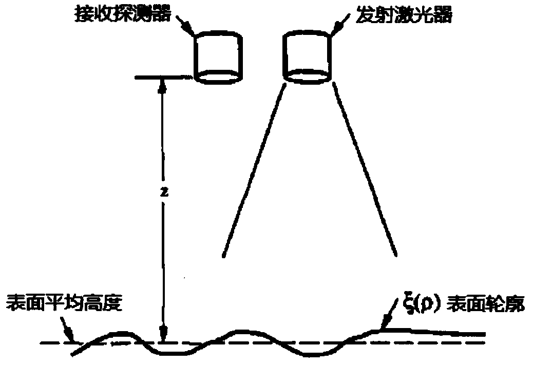
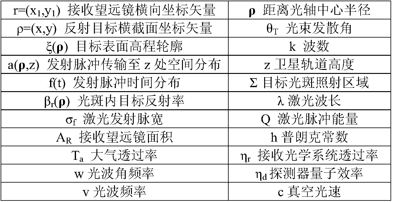
[0056] According to Gardner's theory, the emitted laser pulse undergoes a Fresnel diffraction, is incident on the surface of the earth, is reflected by the target, and then undergoes a Fresnel diffraction. The complex amplitude of the light wave before reaching the field of view of the receiving telescope is expressed as (1). When the geometric position relationship is as figure 1 shown.

[0057] u r ( r , z , t ) = T a λz exp [ i ( ωt - 2 kz + kr 2 2 ...


PUM


Abstract

The invention relates to the field of laser remote sensing technology, in particular to a satellite-borne laser altimeter system solid surface target plane and height accuracy test method. A satellite-borne laser altimeter system is set up to measure solid surface distance accuracy and a height accuracy mathematical model, a complete altimeter system accuracy rapid test method is designed, an echo energy calculation method related to a specific implementation process is derived, and a surface target parameter calculation method is designed. According to the method, ranging accuracy between a satellite laser reference point and a surface target can be tested when known altimeter system hardware parameters and surface target parameters are tested, and plane and height accuracy of a laser altimeter system can also be detected by combining satellite platform attitudes and position data. The plane and height accuracy test method has a high reference significance in laser altimeter system parameter design and accuracy assessment.

Description

technical field [0001] The invention relates to a method for detecting the plane and elevation accuracy of a solid surface target in an altimetry system, in particular to a method for detecting the plane and elevation accuracy of a solid surface object in a spaceborne laser altimetry system. Background technique [0002] The space-borne laser altimetry system is an active measurement system. By receiving the weak echo of the laser pulse emitted by the satellite platform laser and reflected by the ground surface, it accurately calculates the transit time of the laser pulse between the satellite and the ground, and obtains the satellite and ground surface. Combined with the precise orbit and attitude data of the satellite, the precise geographic location and elevation results of the laser footpoint are generated. Through the continuous operation of the satellite, the DEM model covering the earth's surface is finally obtained. [0003] The laser pulses emitted by the laser alt...

Claims


Application Information

Patent Timeline
Patent Type & Authority Applications(China)
IPC IPC(8): G01S17/08G01S7/497
CPCG01S7/497G01S17/08
Inventor 马跃李松阳凡林杨东清刘洪霞
Owner SHANDONG UNIV OF SCI & TECH
Learn More