Assessment method for road network function gradation state grades

A technology of function level and state level, applied in the field of level evaluation, can solve the problem of no inspection and analysis of road network usage status

Active Publication Date: 2014-07-23
SOUTH CHINA UNIV OF TECH
View PDF4 Cites 7 Cited by
  • Summary
  • Abstract
  • Description
  • Claims
  • Application Information

AI Technical Summary

Problems solved by technology

[0003] Although a lot of research has been done on road network evaluation at home and abroad, there is no research on the use of the above-mentioned functional levels of the road network.

Method used


Image

  • Assessment method for road network function gradation state grades
  • Assessment method for road network function gradation state grades
  • Assessment method for road network function gradation state grades

Examples


Embodiment Construction

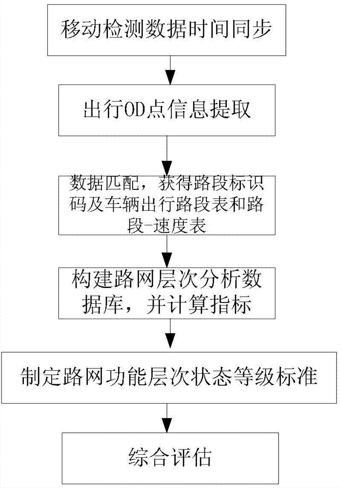
[0081] The present invention will be described in further detail below in conjunction with the embodiments and the accompanying drawings, but the embodiments of the present invention are not limited thereto.

[0082] This embodiment tests the Beijing road network, and its implementation steps are as attached figure 1 as shown,

[0083] Then the time difference method is used to synchronize the time between the mobile detection vehicle IC card and the GPS data.

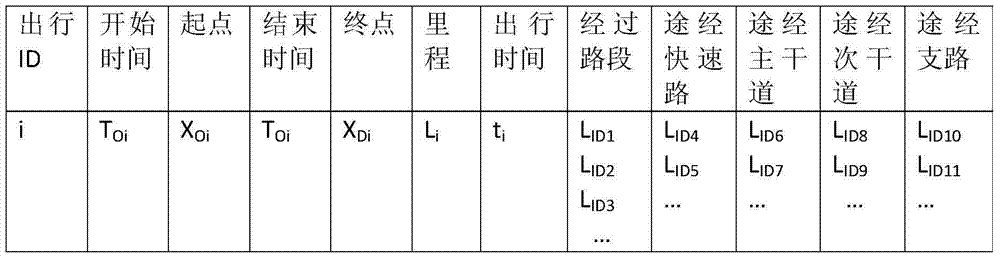
[0084] Then, according to the synchronized mobile detection vehicle IC card, the start point and end point time data T of each trip O , T D , to extract the GPS data in T O , T D Corresponding location data X O , X D , realize the data fusion of IC card and GPS to determine the time and location information of the starting and ending points of each trip (T O , X O ) and (T D , X D ).

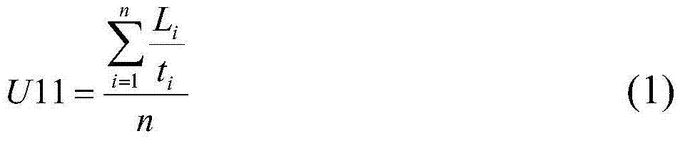
[0085] Then use references Zhang Wei, Xu Jianmin, Lin Mianfeng. Map matching algorithm based on large-scale floating car dat...


PUM


Abstract

The invention discloses an assessment method for road network function gradation state grades. The assessment method includes the steps that time synchronization is performed on an IC card of a taxi serving as a motion detection vehicle and vehicle-mounted GPS data of the vehicle; time and position information of an initial point O and an end point D is recorded when people go out every time; a vehicle-mounted GPS matches the position information of the initial point and the end point with electronic map data to obtain road segment identification codes corresponding to position of the initial point and the position of the end point, a vehicle traveling-road segment chart and a road segment-speed chart when people go out every time; a road network gradation analysis database is constructed, and index values of road network function gradation analysis are calculated; standards of the road network function gradation state grades are set; according to the comprehensive grade C of road network function gradation analysis, the road network function gradation state grades are assessed. The assessment method is flexible, and history data of traffic information are sufficiently utilized.

Description

technical field [0001] The invention relates to the field of traffic management, in particular to a method for evaluating road network function levels and status levels. Background technique [0002] The road network has a certain hierarchy, which has been taken into consideration when planning the road network. China's "Highway and Urban Road Design Manual" clearly defines the main functions of roads at all levels, whether it is expressways, first-class roads, second-class roads, and two-lane roads in the road network, or expressways in the urban road network system. Roads, main roads, sub-arterial roads and branch roads, there is a clear hierarchy of functions between different grades of roads. The integration and optimization of road network is a major traffic problem that both traffic engineering and traffic planning disciplines are concerned about. A road system with chaotic functional levels will inevitably affect the smooth flow of traffic and reduce the service leve...

Claims


Application Information

Patent Timeline
Patent Type & Authority Applications(China)
IPC IPC(8): G08G1/01
Inventor 黄玲
Owner SOUTH CHINA UNIV OF TECH
Why Eureka
Try Eureka