Close combination navigation method of multi-satellite system and strapdown inertial navigation system

A strapdown inertial navigation and satellite system technology, applied in the field of multi-satellite system and strapdown inertial navigation system tightly combined navigation and combined solution

Active Publication Date: 2014-08-06
SOUTHEAST UNIV
View PDF0 Cites 40 Cited by
  • Summary
  • Abstract
  • Description
  • Claims
  • Application Information

AI Technical Summary

Problems solved by technology

[0003] Aiming at the problem of inertial navigation and single-satellite integrated navigation in complex environments suc

Method used


Image

  • Close combination navigation method of multi-satellite system and strapdown inertial navigation system
  • Close combination navigation method of multi-satellite system and strapdown inertial navigation system
  • Close combination navigation method of multi-satellite system and strapdown inertial navigation system

Examples


Embodiment Construction

[0061] Below in conjunction with accompanying drawing, further illustrate the present invention.

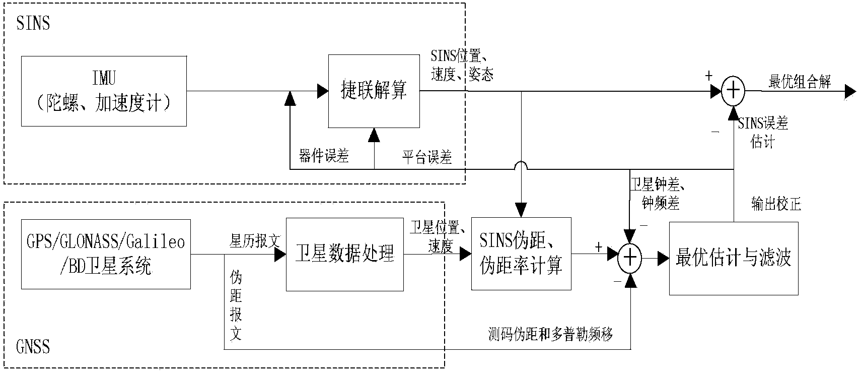
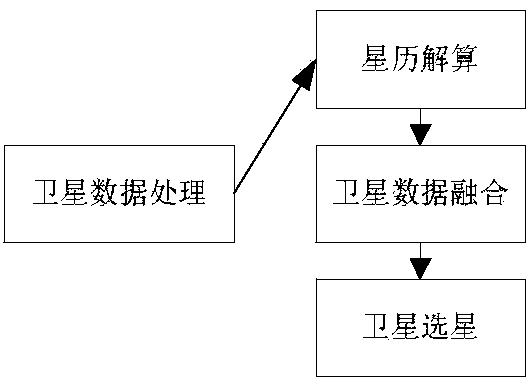
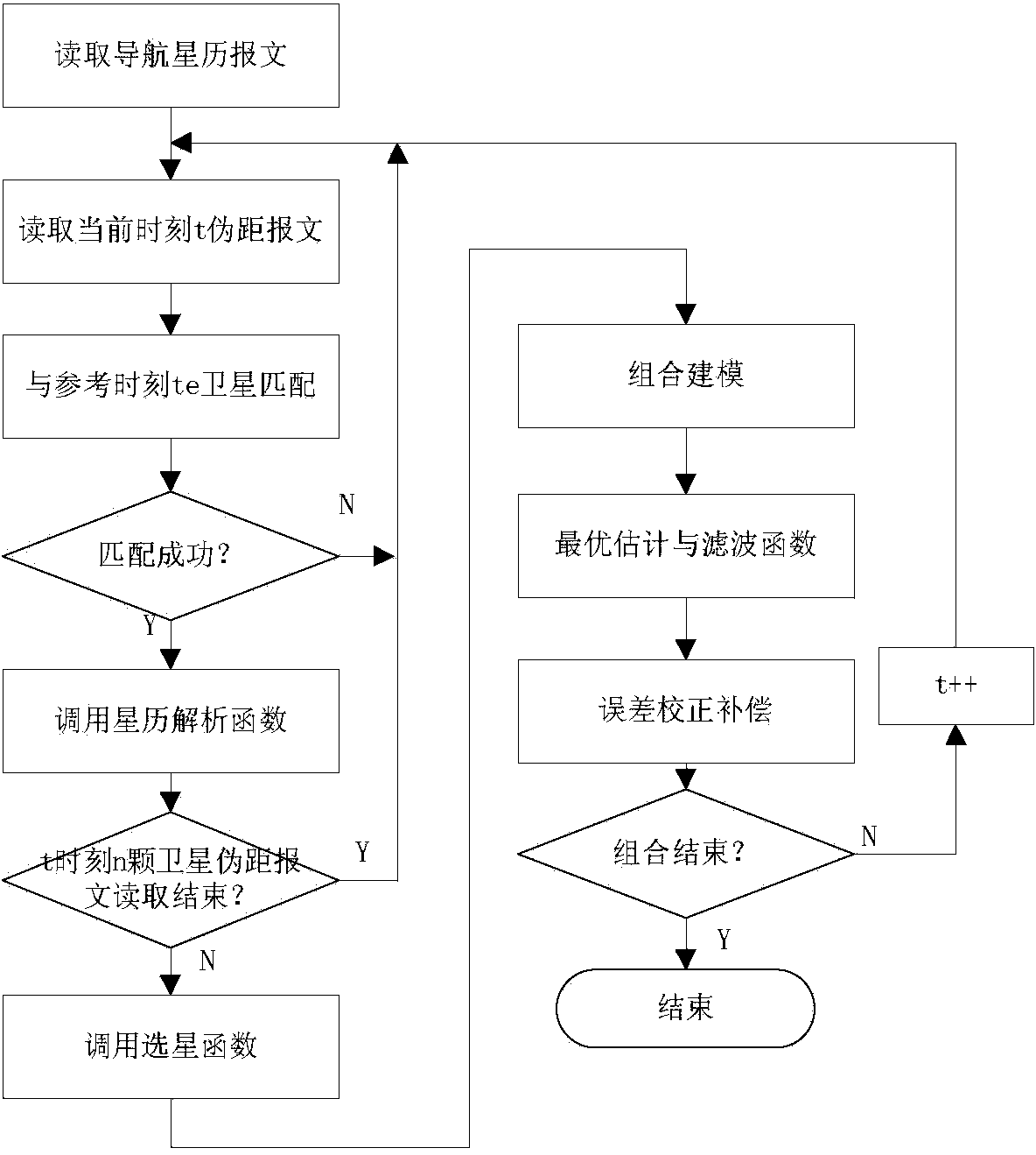
[0062] like figure 1 As shown, the present invention adopts the tight combination method to complete the combined navigation. In order to improve the accuracy of the system in a complex environment, the invention adopts the method of multi-satellite system data processing and multi-satellite system and SINS combined navigation. The specific implementation steps are as follows:

[0063] (1) Obtain the current attitude, velocity and position of the strapdown inertial navigation through the strapdown calculation of the output data of the inertial measurement unit (IMU).

[0064] SINS attitude angle calculation:

[0065] The attitude matrix is ​​calculated by the quaternion method. According to Euler's theorem, the orientation of the moving coordinate system relative to the reference coordinate system is equivalent to the rotation of the moving coordinate system around an equivalent...


PUM


Abstract

The invention discloses a close combination navigation method of a multi-satellite system and a strapdown inertial navigation system. The method comprises the steps that first, strapdown calculating is conducted on IMU output data to acquire the current gesture, speed and position information of an SINS, ephemeris calculating is conducted on a satellite ephemeris message to obtain the positions and the speeds of all satellites, all satellite systems achieve time-space uniformity, and satellite selecting is conducted; secondary, the selected satellite positions and the speed information are used for being calculated with the SINS position and the speed information which are obtained through strapdown calculating to obtain an SINS pseudorange and pseudo-range rate; then, the original measuring data output by a GNSS, namely a code measuring pseudorange and doppler frequency shift, are used for being compared with the SINS pseudorange and the pseudo-range rate, a difference value is used as the observed quantity of a filter, through optimal estimation of the filter, the compensation dosage for correcting the SINS is given, and closed loop correction is conducted to obtain the optimal solution of the SINS gesture, speed and position. The close combination navigation method of the multi-satellite system and the strapdown inertial navigation system solves the problems that the number of satellites is too small in the complex environment with high building blocking and trees covering of combination navigation of inertial navigation and one single satellite, so that the combination navigation precision is influenced.

Description

technical field [0001] The invention belongs to the technical field of navigation, and in particular relates to a tightly combined navigation method of a multi-satellite system and a strapdown inertial navigation system, which is especially suitable for combined solution under complex environments such as tall buildings and trees, when the number of satellites is too small. Background technique [0002] Inertial navigation is based on Newton's classical laws of motion mechanics. It is an autonomous dead reckoning navigation that uses inertial measurement elements to measure the angular motion and linear motion parameters of the carrier, and recursively determines the attitude, velocity and position of the carrier based on the initial state. method. At present, inertial navigation technology has been developed relatively maturely, but it cannot fully meet the requirements for high-precision navigation such as long-distance navigation and weapon launch. Its main disadvantage i...

Claims


Application Information

Patent Timeline
IPC IPC(8): G01S19/49
CPCG01C21/165G01S19/49
Inventor 张涛宫淑萍徐晓苏王立辉李瑶李佩娟
Owner SOUTHEAST UNIV
Why Eureka
Try Eureka