Rural network node radiation domain-oriented rural residential area renovation zoning method

A technology of network nodes and settlements, applied in data processing applications, instruments, computing, etc., can solve the problems of neglecting social and economic differences and correlations, unclear spatial directionality, and lack of practical guidance for rural settlements in villages, towns and villages. , to achieve the effect of improving scientificity and operability

Active Publication Date: 2014-08-06
WUHAN UNIV
View PDF3 Cites 7 Cited by
  • Summary
  • Abstract
  • Description
  • Claims
  • Application Information

AI Technical Summary

Problems solved by technology

However, these two types of methods both use the existing administrative boundaries as the zoning boundaries, ignoring the social and economic differences and correlations between different villages and towns, as well as the impact of the actual spatial scope of villages and towns on the remediation and development direction of...

Method used


Image

  • Rural network node radiation domain-oriented rural residential area renovation zoning method
  • Rural network node radiation domain-oriented rural residential area renovation zoning method
  • Rural network node radiation domain-oriented rural residential area renovation zoning method

Examples


Embodiment

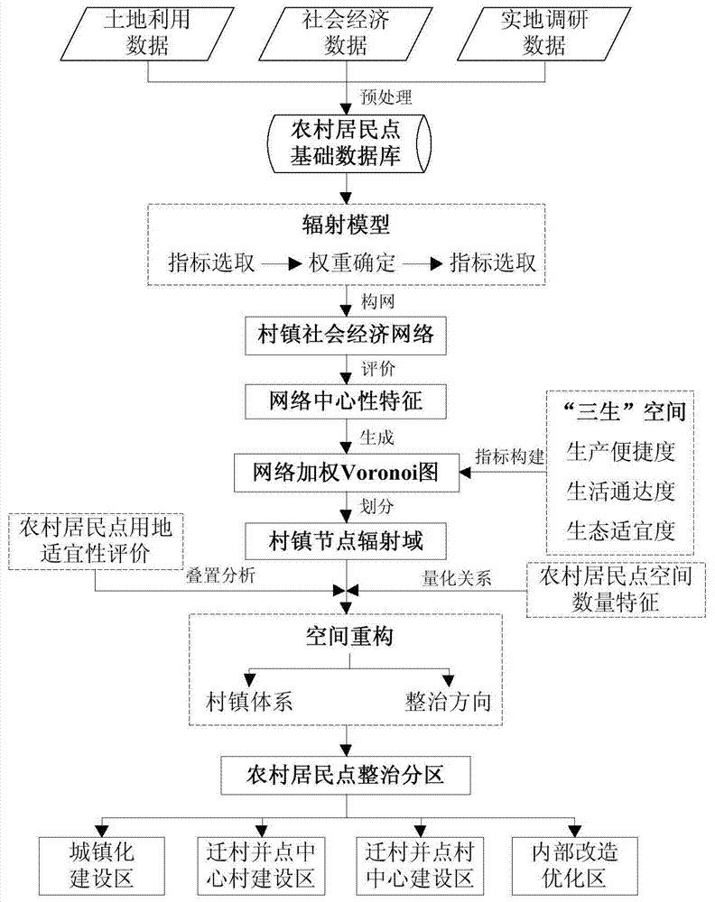
[0039] The model flow chart that the present invention adopts is as figure 1 Show.

[0040] The method for remediation and zoning of rural residential areas includes the following steps:

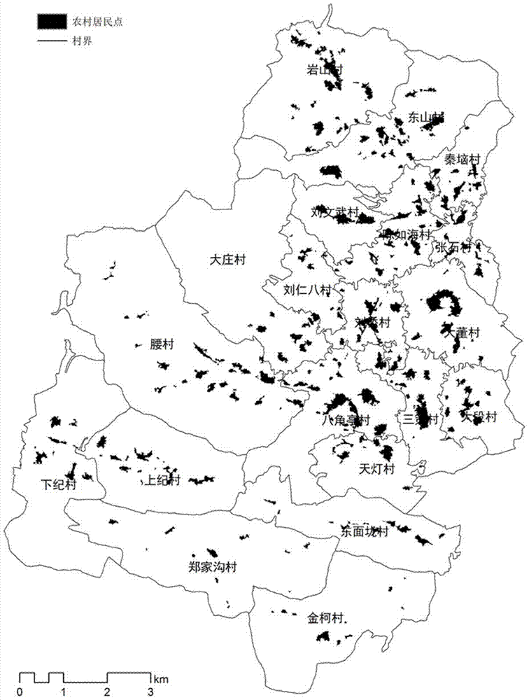
[0041] Step 1. Data processing and analysis. Extract the spatial characteristic information and economic and demographic information of rural residential areas of each administrative village unit from land use data and socioeconomic data, analyze the correlation between the spatial quantitative characteristics of rural residential areas and economic and demographic characteristics, and build the basis of rural residential areas database.

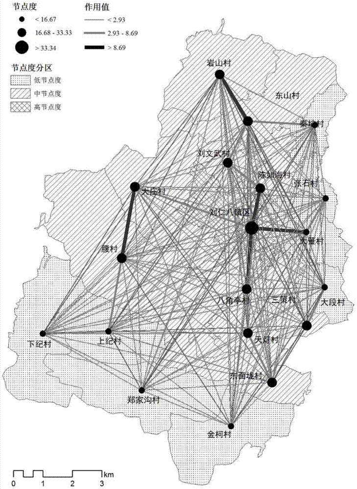
[0042] Step 2. Build the social and economic network of villages and towns. ①Location of network nodes, setting the nodes at the location of each village committee or town government; ②The matrix of connection strength between villages and towns, based on the 4 statistics of the total population of each village, the scale of urban land use, the scale of...


PUM


Abstract

The invention relates to a rural network node radiation domain-oriented rural residential area renovation zoning method. The renovation zoning method comprises the following steps: firstly, establishing a rural social economic network on the basis of a radiation model, then extracting the network centrality, constructing a rural residual area land demand-oriented network node evaluation index, determining a network node radiation domain through generating a rural network weighing Voronoi map, calculating the spatial quantitative relation between the network node radiation domain and rural residential area to determine a rural system and a zoning level, thus forming a rural residential area renovation zoning result through combining the land suitability evaluation of the rural residential area. The method comprehensively considers the practical space action range of rural nodes in the renovation of the rural residential area, integrates the rural social economic network relation into the weighing Voronoi map, thus breaking through the bound limit of the traditional administrative region, solving the deficiency of the current zoning social relevance and space directivity, and improving the renovation zoning scientificity and operability of the rural residential area.

Description

technical field [0001] The invention relates to a village and town network node radiation domain-oriented method for the regulation and zoning of rural residential areas, which integrates a radiation model and a weighted Voronoi diagram to realize the zoning of rural residential areas, and belongs to the field of land use planning. Background technique [0002] Renovation and zoning of rural residential areas is an important way to improve the economical and intensive level of rural land use and optimize the urban-rural spatial structure. It is based on the comprehensive consideration of the social and economic connections of villages and towns and the spatial and quantitative characteristics of rural residential areas, to determine the mode, scope and optimization direction of rural residential area renovation, and to provide technical support for the spatial reconstruction and rational layout of rural residential areas. The spatial layout of rural residential areas reflect...

Claims


Application Information

Patent Timeline
IPC IPC(8): G06Q50/26
Inventor 刘耀林孔雪松刘艳芳刘殿锋
Owner WUHAN UNIV
Why Eureka
Try Eureka