A Realization Method of Inertial Assisted GPS Receiver

A technology of a GPS receiver and an implementation method, which is applied to satellite radio beacon positioning systems, measuring devices, instruments, etc., can solve the problem of losing GPS signal tracking and locking, high Doppler frequency shift rate of change, and GPS signal Doppler frequency. It is easy to realize, improve the tracking performance, and achieve the effect of high tracking accuracy

Active Publication Date: 2017-02-15
SOUTHEAST UNIV
View PDF2 Cites 0 Cited by
  • Summary
  • Abstract
  • Description
  • Claims
  • Application Information

AI Technical Summary

Problems solved by technology

In a highly dynamic environment, the Doppler frequency shift of the GPS signal caused by the high-speed maneuvering of the carrier is very large, and the change rate of the Doppler frequency shift is very high. Therefore, without external assistance such as inertial devices, the traditional GPS The receiver's tracking loop can easily lose track lock to the GPS signal

Method used


Image

  • A Realization Method of Inertial Assisted GPS Receiver
  • A Realization Method of Inertial Assisted GPS Receiver
  • A Realization Method of Inertial Assisted GPS Receiver

Examples


Embodiment Construction

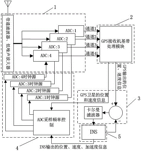
[0019] The present invention will be further explained below in conjunction with the accompanying drawings. The structure of the present invention is as figure 1 as shown,

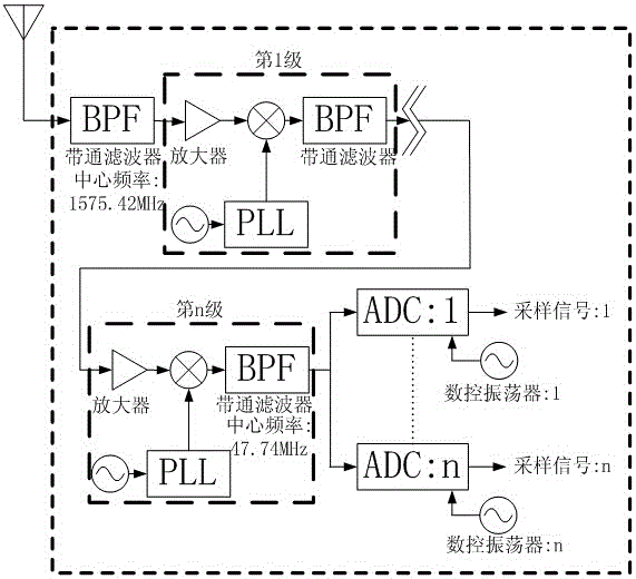
[0020] The INS inertial navigation system (5) measures the position, velocity and attitude data of the carrier; the GPS satellite receiver radio frequency front end (1) with adjustable sampling frequency receives GPS satellite signals, and converts the received satellite signals into intermediate frequency digital signals; GPS The satellite receiver baseband processing module (2) demodulates the intermediate frequency digital signal and calculates the time / position to obtain the carrier position and GPS satellite navigation message; the INS / GPS combined filter (3) converts the INS navigation data through the Kalman filter Perform data fusion with GPS navigation data to generate error-corrected INS navigation data and GPS navigation data; ADC sampling frequency adjustment module (4) calculates the specifi...


PUM


Abstract

The invention relates to an INS / GPS combination method of an INS assisted GPS receiver radio frequency front end. Firstly, INS navigation information and GPS navigation information are fused through a combined filter, the INS navigation information errors are corrected, then the corrected INS navigation information and GPS navigation messages are utilized for calculating Doppler frequency shift, relative to each satellite, of a carrier, and the obtained Doppler frequency shift is converted into wavelength changes of a GPS intermediate frequency signal carrier wave. Finally, according to the wavelength changes of the carrier wave, the sampling time interval of an ADC at the GPS receiver radio frequency front end is adjusted in real time, changes, caused by Doppler frequency shift, of an Doppler frequency shift digital signal sampling point can be compensated, and the influence of the Doppler frequency shift on a tracking loop of the GPS receiver can be avoided.

Description

technical field [0001] The invention relates to an INS-assisted GPS receiver system. The GPS receiver system solution has excellent high dynamic performance and is suitable for GPS positioning applications in high dynamic environments such as high-speed fighter jets and missiles. Background technique [0002] GPS (Global Positioning System) is currently the most widely used satellite navigation and positioning system, which is widely used in civil and military fields, especially in high dynamic environments such as precision guided missiles. For a GPS receiver installed on a moving carrier, according to the speed and acceleration characteristics of the carrier movement, the working environment of the GPS receiver can be divided into three types: static environment, medium and low dynamic environment and high dynamic environment. Typically, a carrier motion environment with high velocity, acceleration, and jerk is defined as a highly dynamic environment. Taking the maneuveri...

Claims


Application Information

Patent Timeline
Patent Type & Authority Patents(China)
IPC IPC(8): G01S19/47
CPCG01C21/165G01S19/25G01S19/47
Inventor 陈熙源王熙赢方琳崔冰波宋锐汤传业
Owner SOUTHEAST UNIV
Why Eureka
Try Eureka