Traffic real-time image system for Beidou satellite navigation positioning and method thereof

A navigation positioning and Beidou satellite technology, applied in the field of navigators, can solve the problems of loss, misunderstanding, inability to determine the itinerary and work arrangement in the case of traffic jams, and achieve the effect of avoiding losses

Inactive Publication Date: 2014-08-27
东莞康特尔云终端系统有限公司
View PDF0 Cites 10 Cited by
  • Summary
  • Abstract
  • Description
  • Claims
  • Application Information

AI Technical Summary

Problems solved by technology

[0003] In addition, people often encounter congestion during travel. If there is an urgent matter to be dealt with at this time, they need to understand the congestion situation in order to arrange time and relevant p

Method used


Image

  • Traffic real-time image system for Beidou satellite navigation positioning and method thereof

Examples


Example Embodiment

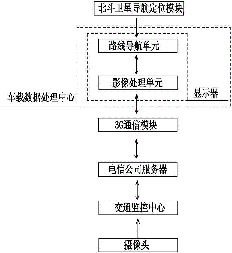
[0012] Please refer to figure 1 As shown, it shows a schematic flow diagram of a preferred embodiment of the present invention, a Beidou satellite navigation and positioning traffic instant image system, including Beidou satellite navigation and positioning module, vehicle data processing center, mobile communication module, traffic monitoring center and A plurality of cameras, the vehicle data processing center is provided with a display, the display includes a route navigation unit and an image processing unit, the output end of the Beidou satellite navigation positioning module is connected with the input end of the route navigation unit, and the image processing unit communicates via mobile The module is connected with the traffic monitoring center, and the output terminal of the camera is connected with the input terminal of the traffic monitoring center.

[0013] The route navigation unit is a Beidou satellite navigation and positioning vehicle-mounted terminal.

[0014] The...


PUM


Abstract

The invention discloses a traffic real-time image system for Beidou satellite navigation positioning and a method thereof. The system includes a Beidou satellite navigation positioning module, a vehicle-mounted data processing center, an action communication module, a traffic monitoring center and a plurality of cameras. In the traffic real-time image method for the Beidou satellite navigation positioning, real-time image data of a real-time traffic information specific position which needs to be mastered is selected in a line navigation unit through data provided in the Beidou satellite navigation positioning module and at the moment, the vehicle-mounted data processing center transmits a signal instruction to a traffic monitoring center through the action communication module and the traffic monitoring center transmits real-time video images of cameras at corresponding positions from the action communication module to the vehicle-mounted data processing center after identifying the signal instruction. The image processing unit plays real-time video images of a camera at current position so as to complete video check of the real-time traffic information specific position which needs to be mastered.

Description

Technical field [0001] The invention relates to the technical field of navigators, in particular to a Beidou satellite navigation and positioning real-time traffic image system and method thereof. Background technique [0002] In recent years, with the rapid development of the world economy, the traffic load has increased dramatically, and the subsequent problems such as serious road congestion and frequent traffic accidents have gradually become the main factors restricting the development of transportation in various countries. Therefore, timely and correct identification of road traffic congestion is a prerequisite for taking reasonable early warning measures and proactively avoiding traffic congestion. At the same time, it can also provide reference for public travel and urban traffic dispatch and is an effective means to improve road capacity. [0003] In addition, people often encounter congestion during travel. If there is an urgent matter that needs to be dealt with at this...

Claims


Application Information

Patent Timeline
IPC IPC(8): G08G1/0968H04N7/18
Inventor 郑景鸿
Owner 东莞康特尔云终端系统有限公司
Why Eureka
Try Eureka