Satellite hyper-spectral image compressed sensing reconstruction method based on image sparse regularization

A hyperspectral image and compressed sensing technology, which is applied in the field of satellite hyperspectral image compressed sensing reconstruction, can solve the problems of underutilized spatial correlation, ignoring the multi-band structure of hyperspectral image, and low accuracy and efficiency of hyperspectral data reconstruction. , to achieve the effect of promoting lightweight design, reducing complexity and improving success rate

Active Publication Date: 2014-09-24
NANJING UNIV OF SCI & TECH
View PDF1 Cites 23 Cited by
  • Summary
  • Abstract
  • Description
  • Claims
  • Application Information

AI Technical Summary

Problems solved by technology

However, there are still problems with the above-mentioned technology: (1) The multi-band structure of the hyperspectral image is ignored, and the multi-channel hyperspectral signals are rearranged into long vectors for single compression sampling during the measurement process at the encoding end. This kind of coupling (dense) The measurement method is not conducive to the hardware implementation of the hyperspectral measurement device, and cannot perform adaptive sampling according to the statistical characteristics of each spectral band; (2) the reconstruction model during decoding only uses the correlation between the spectral bands, and for the spectral bands The spatial correlation within is not fully utilized, resulting in low accuracy and efficiency of hyperspectral data reconstruction
The above problems make the compressive sensing reconstruction technology of satellite hyperspectral images far from practical application.

Method used


Image

  • Satellite hyper-spectral image compressed sensing reconstruction method based on image sparse regularization
  • Satellite hyper-spectral image compressed sensing reconstruction method based on image sparse regularization
  • Satellite hyper-spectral image compressed sensing reconstruction method based on image sparse regularization

Examples


Embodiment Construction

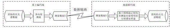
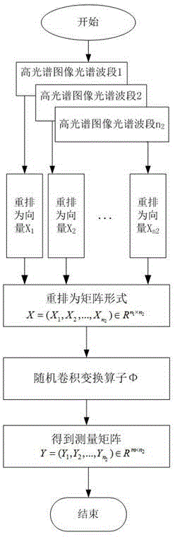
[0017] combine figure 1 , a satellite hyperspectral image compressive sensing reconstruction method based on graph sparse regularization, including random measurement of hyperspectral data at the encoding end on the satellite and compressive sensing reconstruction at the decoding end on the ground;

[0018] The random measurement process of hyperspectral data at the coding end on the star is:

[0019] Step 1, rearrange the known three-dimensional cube of hyperspectral data into a matrix X;

[0020] Since the hyperspectral image contains dozens to hundreds of spectral segments, the present invention pulls the images in each band of a multi-band three-dimensional volume hyperspectral image into a column vector, and then merges the column vectors of each band to form a new The data matrix X

[0021] X = x 11 x ...


PUM


Abstract

The invention provides a satellite hyper-spectral image compressed sensing reconstruction method based on image sparse regularization. The method comprises the following steps: Step 1, the three-dimensional cube of known hyper-spectral data is rearranged into a matrix; Step 2, a multi-vector measurement model is constructed with a stochastic convolution transform as a linear observation matrix, and each waveband is independently sampled to generate a measurement vector matrix; Step 3, a hyper-spectral image is decomposed in a sparse transform domain into a spectral association component and a difference component, and an image sparse regularization joint reconstruction model including the association component and the difference component is constructed; and Step 4, an alternating-direction multiplier iteration algorithm for solving the joint reconstruction model is put forward, the association component and the difference component of a transform domain are obtained, and then the association component and the difference component are merged to obtain reestablished hyper-spectral data. The method provided by the invention is high in degree of compression and high in precision during satellite hyper-spectral remote sensing data compression.

Description

technical field [0001] The invention belongs to the field of remote sensing image processing, and in particular relates to a satellite hyperspectral image compression sensing reconstruction method based on a graph sparse regularization multi-measurement vector model. Background technique [0002] With the development of telemetry technology, the spectral resolution and spatial resolution of hyperspectral remote sensing images are getting higher and higher, which can be used to effectively detect and identify the types of ground objects, and have broad application prospects in ground object recognition and geological surveys. However, the high spatial and spectral resolution also generates a large amount of measurement data, which brings difficulties to the storage, transmission and subsequent processing of hyperspectral remote sensing detection data. In particular, the continuous work of space-borne hyperspectral sensors will generate massive amounts of data, making it very ...

Claims


Application Information

Patent Timeline
Patent Type & Authority Applications(China)
IPC IPC(8): G06T17/00
Inventor 徐洋吴泽彬孙玉宝刘建军孙乐韦志辉
Owner NANJING UNIV OF SCI & TECH
Why Eureka
Try Eureka