
Commodity picture based indoor positioning method
An indoor positioning and commodity technology, applied in the field of indoor positioning based on commodity pictures, can solve the problems of high cost and complex positioning system structure, and achieve the effect of high positioning accuracy
- Summary
- Abstract
- Description
- Claims
- Application Information
AI Technical Summary
Problems solved by technology
Method used
Image

Examples
Embodiment Construction
[0016] The present invention will be further described below in conjunction with the accompanying drawings and specific embodiments.
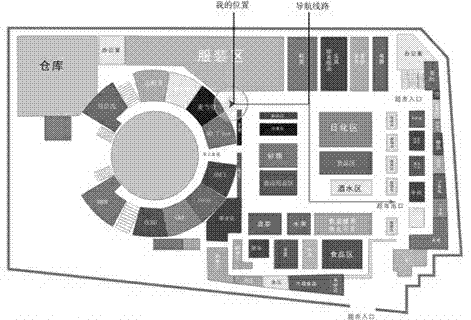
[0017] see figure 1 : figure 1 It is the floor plan of the supermarket, with the supermarket as the positioning area, and various commodities are placed in different blocks and categories in the supermarket.
[0018] The indoor positioning method based on the product picture includes the following steps:
[0019] 1) Establishment of the database: draw the floor plan of the positioning area, and draw the commodity placement blocks in the floor plan, and number each block. The number is unique in the same positioning area. The map and number are sent to the location server and stored in the location server's database. Use image acquisition equipment to collect picture information of commodities in the positioning area, and use block numbers to number the picture information. Send the numbered picture information to the location server through...
PUM
 Abstract
Description
Claims
Application Information