Ground three-dimensional laser point cloud based method for realizing automatic extraction of geologic body occurrence

A 3D laser and automatic extraction technology, applied in image data processing, 3D modeling, instruments, etc., can solve the problem that 3D point cloud data does not involve color information, etc., to reduce field measurement work, improve segmentation effect, and reduce impact Effect

Inactive Publication Date: 2014-12-03
ZHEJIANG UNIV
View PDF1 Cites 19 Cited by
  • Summary
  • Abstract
  • Description
  • Claims
  • Application Information

AI Technical Summary

Problems solved by technology

In addition, most of the current research on 3D point cloud data does not involve its color information RGB

Method used


Image

  • Ground three-dimensional laser point cloud based method for realizing automatic extraction of geologic body occurrence
  • Ground three-dimensional laser point cloud based method for realizing automatic extraction of geologic body occurrence
  • Ground three-dimensional laser point cloud based method for realizing automatic extraction of geologic body occurrence

Examples


Embodiment Construction

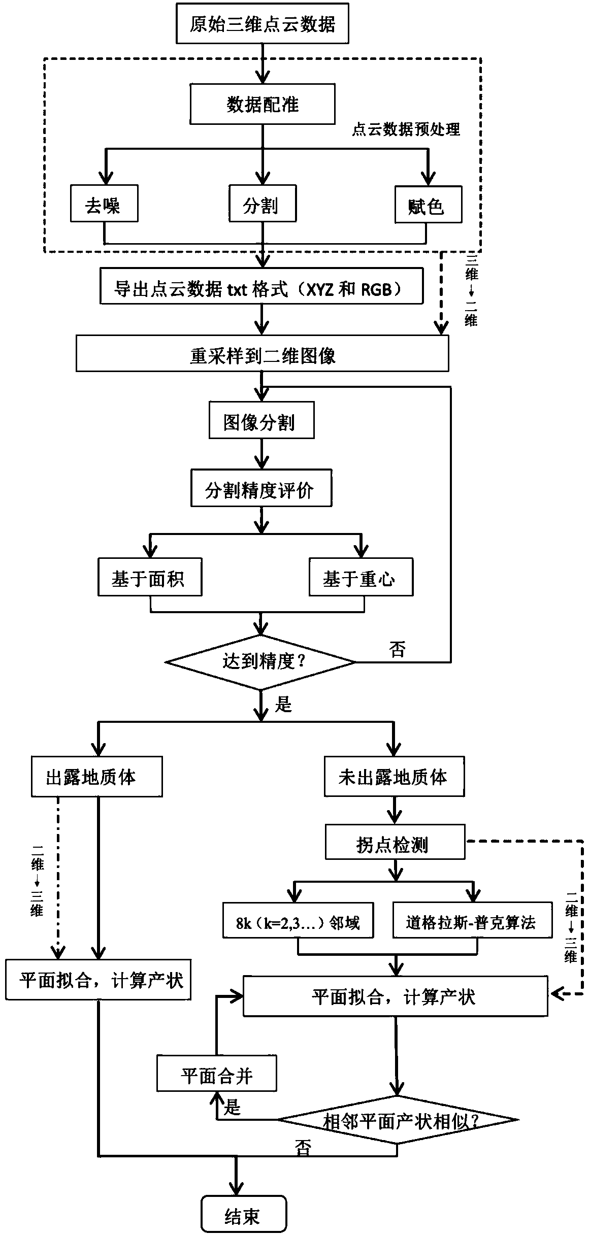
[0021] Such as figure 1 As shown, the present invention realizes the automatic extraction method of geological body occurrence based on the ground three-dimensional laser point cloud, comprising the following steps:

[0022] 1. Collect 3D laser point cloud data through a 3D laser scanner;

[0023] During the scanning process of the 3D laser scanner Riegl VZ100, due to the limitation of the field of view of the laser scanner, the scanning range of a single site often cannot cover the entire research area, so multi-site scanning is required, and there must be overlapping areas between different sites , in order to realize the registration of point cloud data between different sites; for details, please refer to the literature "Simon J, Buckley J A, et al, 2008. Terrestrial laser scanning in geology: data acquisition, processing and accuracy considerations. Journal of Geological Society, London, 165:625-638";

[0024] 2. Preprocess the 3D laser point cloud data collected in st...


PUM


Abstract

The invention discloses a ground three-dimensional laser point cloud based method for realizing automatic extraction of geologic body occurrence. Through utilization of space position and color information of three-dimensional point cloud data and combination of image segmentation and inflection point detection technologies, automatic extraction of the occurrence of exposed geologic body and unexposed geologic body can be realized. The method comprises the steps of acquiring and preprocessing point cloud data; obtaining a text format of the point cloud data; re-sampling the point cloud data to a two-dimensional image through a nearest neighbor method; splitting the two-dimensional image; evaluating the image splitting accuracy; and respectively fitting the exposed geologic body and the unexposed geologic body and computing the occurrence thereof, wherein the unexposed geologic body shows a linear feature in the two-dimensional image, and the large angular variation of the line trend represents the change of the occurrence of the unexposed geologic body, so that computing of the occurrence of the unexposed geologic body is complicated and relates to technologies like inflection point detection, stereographic projection and so on. The method has very important practical application value in extraction of occurrence of the geologic body, and greatly reduces dangerous field measurement work which is time-consuming and effort-consuming.

Description

technical field [0001] The invention relates to the field of three-dimensional point cloud and image segmentation technology and structural geological science, in particular to a method for automatically extracting the occurrence of geological bodies with a high-precision, high-density, three-dimensional laser point cloud containing spatial and color information. Background technique [0002] The dominant occurrence and geometric information of rock mass structural planes are important indicators for evaluating the development of rock mass structural planes, especially for joints and fissures that are small in scale, large in data, and randomly distributed in structural planes. important parameter. Field measurement is not only time-consuming and labor-intensive, but also in some dangerous areas, personnel cannot reach. Three-dimensional laser scanning is a long-distance non-contact automatic three-dimensional scanning technology, also known as "real scene replication techn...

Claims


Application Information

Patent Timeline
Patent Type & Authority Applications(China)
IPC IPC(8): G06T17/05
Inventor 陈宁华倪妮娜陈建裕
Owner ZHEJIANG UNIV
Why Eureka
Try Eureka