High-precision satellite navigation implementing method based on Android kernel layer

A positioning method, satellite navigation technology, applied in navigation, surveying and mapping and navigation, road network navigator, etc., can solve problems that are difficult and difficult for third-party App developers to use

Active Publication Date: 2014-12-24
武汉六点整北斗科技有限公司
View PDF2 Cites 46 Cited by
  • Summary
  • Abstract
  • Description
  • Claims
  • Application Information

AI Technical Summary

Problems solved by technology

[0005] At present, it is difficult to implement high-precision positioning in the intelligent operating system of the vehicle, and it is difficult for third-party App developers to use it.

Method used


Image

  • High-precision satellite navigation implementing method based on Android kernel layer
  • High-precision satellite navigation implementing method based on Android kernel layer
  • High-precision satellite navigation implementing method based on Android kernel layer

Examples


Embodiment

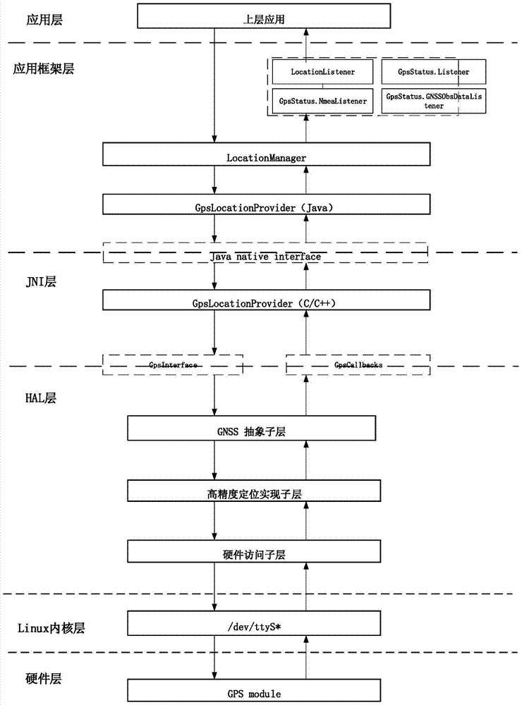
[0047] The specific method of the present invention is set forth below from several aspects.

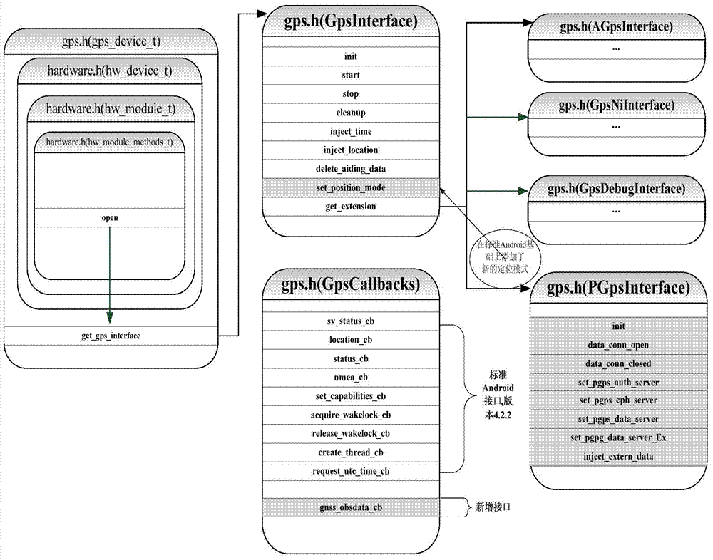
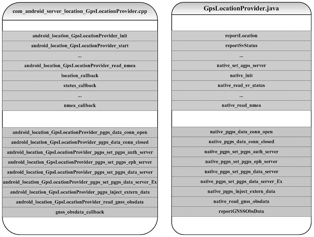
[0048] 1. The present invention starts from the hardware abstraction layer (Hardware Abstraction Layer, HAL) of the Android operating system, and implements a method and a module for realizing functions related to satellite high-precision positioning layer by layer. Specifically: (1) Starting from the HAL layer of the standard Android operating system, increase the abstraction and packaging of the original observation data of the underlying chip (or module) positioning, and increase the high-precision positioning expansion interface and related callback function interfaces layer by layer, and Newly set up a batch of high-precision positioning application programming interfaces (Application Programming Interface, API) in the application framework layer; (2) Add precise point positioning (Precise Point Positioning, PPP), differential positioning, real-time dynamic difference (Real- tim...


PUM


Abstract

The invention relates to a high-precision satellite navigation implementing method based on an Android kernel layer. Specifically, the method comprises, firstly, from the HAL (hardware abstraction layer) of a standard Android operating system, adding abstraction and encapsulation of positioning original observation data of a lower-layer chip or module, then adding high-precision positioning expansion interfaces, relevant callback functional interfaces and the like upwards layer by layer, and newly setting a batch of high-precision positioning application programming interfaces on an application framework layer; secondly, adding precise single point positioning, differential positioning and real-time dynamic differential positioning on the HAL. According to the high-precision satellite navigation implementing method based on the Android kernel layer, Android third-party application developers can obtain high-precision positioning results by calling original standard GNSS (global navigation satellite system) common positioning APIs (application program interface) and obtain original observation data output by positioning hardware on a Java application layer by calling APIs newly added on the Java framework layer of the high-precision satellite navigation implementing method based on the Android kernel layer, thereby achieving customized high-precision positioning.

Description

technical field [0001] The invention relates to the field of high-precision satellite positioning and navigation, in particular to a high-precision satellite navigation and positioning method based on the Android kernel layer used in the Internet of Vehicles and the vehicle-mounted Android system. Background technique [0002] For the automotive electronics industry, there are many emerging things, from the Internet of Vehicles to car navigation, hot spots continue to flow. As the audience increases, so do the types of car navigation. [0003] With the development of science and technology, the combination of intelligent operating systems and vehicles has become the current development trend. Apple's launch of carplay, Google's launch of Android Auto, etc. are typical representatives. This trend represents the development orientation of smart car networking. [0004] High-precision satellite navigation and positioning is to use the ground augmentation system to improve the...

Claims


Application Information

Patent Timeline
Patent Type & Authority Applications(China)
IPC IPC(8): G01C21/34G01C21/36
CPCG01C21/3446
Inventor 郭迟崔竞松郭文飞陈龙侯琨祝勇赵磊辜声峰
Owner 武汉六点整北斗科技有限公司
Why Eureka
Try Eureka