Three-dimensional terrain trafficability analytical method for autonomous land vehicle

A technology of three-dimensional terrain and analysis methods, applied in image analysis, image data processing, special data processing applications, etc., can solve the problems of low analysis efficiency, redundant calculation, inability to meet real-time requirements, etc., to reduce analysis complexity, reduce Analyze the effect of steps

Active Publication Date: 2015-01-07
NAT UNIV OF DEFENSE TECH
View PDF3 Cites 21 Cited by
  • Summary
  • Abstract
  • Description
  • Claims
  • Application Information

AI Technical Summary

Problems solved by technology

Therefore, the safer method is to slide the analysis window with a relatively small step size, which will inevitably lead to low analysis efficiency an

Method used


Image

  • Three-dimensional terrain trafficability analytical method for autonomous land vehicle
  • Three-dimensional terrain trafficability analytical method for autonomous land vehicle
  • Three-dimensional terrain trafficability analytical method for autonomous land vehicle

Examples


Embodiment Construction

[0055] The present invention will be further described in detail below in conjunction with the accompanying drawings and specific embodiments.

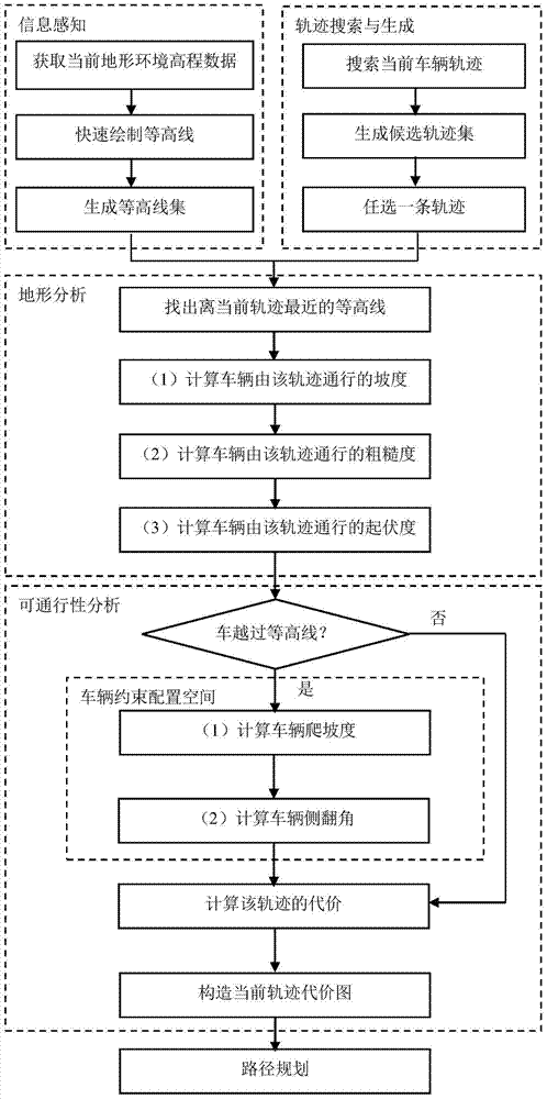
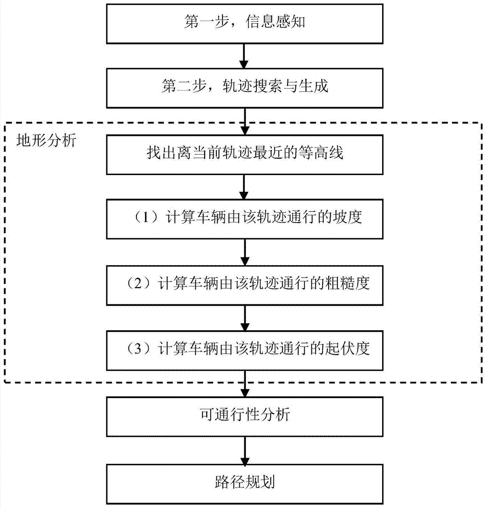
[0056] like Figure 1 to Figure 4 As shown, the autonomous vehicle three-dimensional terrain traversability analysis method of the present invention comprises the following steps:

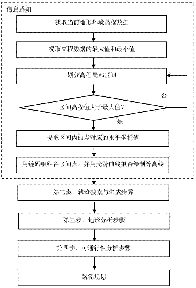
[0057] The first step is the information perception step. Provide environmental information and current vehicle movement status information through on-board sensors. Among them, the environmental information is mainly the terrain elevation data set D={(x i ,y i ,z i ) T |x i ,y i ,z i ∈R,i=1,...,n}, the vehicle motion state information is conf=(x v ,y v ,yaw), (x v ,y v ) is the horizontal plane position of the vehicle at the current moment, yaw is the heading angle, and according to the terrain elevation data obtained by information perception, the contour line of the current terrain is quickly drawn.

[0058] The second step is trajectory se...


PUM


Abstract

A three-dimensional terrain trafficability analytical method for an autonomous land vehicle comprises the step of information perception, wherein movement state information and environmental information of the current vehicle are obtained; the step of track searching and generation, wherein track preliminary searching is carried out according to the current vehicle position and a final target position, and a local track set of possible movements of the vehicle is generated; the step of terrain analysis, wherein the contour line of the current terrain is drawn according to obtained terrain altitude data, the intersection point of a candidate track and the contour line is found according to a vehicle speed v, the terrain characteristics of track curved sections formed by a lower intersection point of the contour line and the current position of the autonomous land vehicle are analyzed, and a basic terrain factor is calculated; the step of trafficability analysis, wherein the cost of each track curved section formed when the vehicle passes is calculated by combining dynamic constraints and kinematical constraints of the vehicle, so that a cost chart is constructed; and the step of route planning, wherein the optimal route is searched with the cost chart serving as heuristic information. The three-dimensional terrain trafficability analytical method for the autonomous land vehicle has the advantages of being simple in principle, easy and convenient to operate, high in identification accuracy, efficient in calculation and the like.

Description

technical field [0001] The invention mainly relates to the field of terrain analysis and path planning of autonomous vehicles, in particular to a method for analyzing the traversability of three-dimensional terrain applicable to autonomous vehicles. Background technique [0002] The navigation and planning of the autonomous vehicle are an integral part of the autonomous vehicle system, and the core of the navigation is how to analyze and extract important information in these data based on the environmental data and positioning data obtained by the on-board sensors, so that the auxiliary autonomous vehicle can use these The information plans an optimal path to reach the target point. As far as local path planning is concerned, three-dimensional terrain can be described by digital elevation maps (Digital Elevation Maps, referred to as DEM) obtained by sensors. The important information analyzed and extracted from DEM is mainly the basic terrain factors that can reflect terrai...

Claims


Application Information

Patent Timeline
IPC IPC(8): G06T7/00G06T17/05G06F17/50
CPCG06Q10/047
Inventor 刘大学周泽寻安向京宋金泽
Owner NAT UNIV OF DEFENSE TECH
Why Eureka
Try Eureka