GIS (geographic information system)-platform based dynamic loading method for real-time weather of graticule data

A dynamic loading and real-time meteorological technology, applied in the GIS field, can solve the problems affecting the operation efficiency of the GIS platform, the large amount of spatial multivariate data, and the large amount of unit data, so as to meet the needs of diversity, high degree of automation, and efficient spatial information services Effect

Inactive Publication Date: 2015-01-14
SHANDONG LUNENG SOFTWARE TECH
View PDF2 Cites 2 Cited by
  • Summary
  • Abstract
  • Description
  • Claims
  • Application Information

AI Technical Summary

Problems solved by technology

[0005] In the GIS platform, due to the large and complex volume of spatial multivariate data, when dividing the grid, the unit data volume is large, which seriously affects the operation efficiency of the GIS p

Method used


Image

  • GIS (geographic information system)-platform based dynamic loading method for real-time weather of graticule data
  • GIS (geographic information system)-platform based dynamic loading method for real-time weather of graticule data

Examples


Embodiment Construction

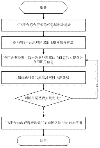
[0040] Accompanying drawing is a kind of specific embodiment of the present invention. The real-time meteorological dynamic loading method of the geographic grid data based on the GIS platform of this embodiment comprises the following steps:

[0041] (1) GIS platform code writing;

[0042] (2) Apply the parallel area division algorithm automatically generated by the finite element grid to divide the basic geographic data of the GIS platform to form a geographic grid;

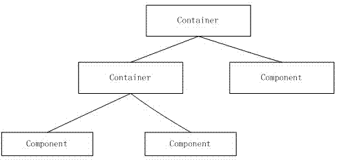
[0043] (3) Write the front-end container code of the GIS platform according to the required display data;

[0044] (4) Add event monitoring to the front-end container of the GIS platform;

[0045] (5) Build the back-end server of the GIS platform;

[0046] (6) Obtain meteorological information in real time, process these massive data, apply the research and implementation of massive data processing algorithms in data mining, and load relevant useful power grid resources or meteorological data;

[0047] (7) ...


PUM


Abstract

The invention relates to a GIS (geographic information system)-platform based dynamic loading method for real-time weather of graticule data. The method includes the following steps: writing and deploying a GIS platform rear-end server code, partitioning a GIS platform measured area by a parallel area partitioning algorithm automatically generated by finite-element grids to form a graticule, acquiring whether information in real time, and accurately checking scope and condition of influences of extreme weather on power-grid factors by a graticule framework at a GIS platform front-end. High automation degree of geographic area grid partition is achieved, requirements on space data diversity and resource dynamics are met, and GIS platform operation efficiency is not affected. The scope and the condition of the influences of the extreme weather on the power-grid factors are accurately checked to acquire useful data in power-grid resources or weather information, so that loading of useless data is avoided, and the GIS platform operation efficiency is improved.

Description

(1) Technical field [0001] The invention relates to GIS technology, in particular to a method for real-time meteorological dynamic loading of geographic grid data based on a GIS platform, related to a parallel area division algorithm automatically generated by finite element grids. (2) Background technology [0002] Geographic grid is a scientific and concise positioning reference system, which is a supplement to the existing measurement reference system, administrative division reference system and other special positioning systems. The geographic grid system originated from early cartographic research, and developed into a basic method for expressing complex geographic phenomena, comprehensively analyzing natural and human data, and simulating the functions and behaviors of geographic systems. The composition of the geographic grid system includes grid cells, grid edges, and grid points. The grid cells represent the regional surface characteristics, the grid points determi...

Claims


Application Information

Patent Timeline
IPC IPC(8): G06F17/30G06F9/44
CPCG06F9/4406G06F16/29G06Q50/06Y02A90/10
Inventor 王勇李冬时翔邓昊刘明林阎振坤李秀梅
Owner SHANDONG LUNENG SOFTWARE TECH
Why Eureka
Try Eureka