Electric transmission line GIS based on AGPS and 4G and implementation method

A transmission line, 4G technology, applied in the field of transmission line GIS system based on AGPS and 4G, can solve the problems of large number of towers and equipment, difficult work, and inability to guarantee the timeliness of data, so as to save the work process of on-site survey and input , Guarantee the effect of reliability and timeliness

Active Publication Date: 2015-01-28
STATE GRID CORP OF CHINA +1
View PDF5 Cites 15 Cited by
  • Summary
  • Abstract
  • Description
  • Claims
  • Application Information

AI Technical Summary

Problems solved by technology

[0003] The spatial coordinates of equipment and facilities such as substations and transmission lines in the existing power grid GIS system are still obtained through manual on-site measurement and manually entered into the GIS system. In the GIS system, the production attributes and operating status of the equipment and facilities are manually connected to each other. There are certain deficiencies in this method, which are mainly reflected in: 1. The work is difficult
The distribution of power facilities is wide and the number is large. On-site measurement, data docking and follow-up maintenance require a lot of human and material resources, and are often limited by objective conditions; 2. Poor real-time performance
The transmission line structure is complex, the number of towers and equipment is large, the routine work process has many links, and the update cycle is long, so the timeliness of data cannot be guaranteed; 3. Poor correlation
The spatial position information of the equipment, the inherent attribute information and the status information of the equipment are manually established and maintained, which greatly increases the workload and is not convenient for later adjustment and expansion.

Method used


Image

  • Electric transmission line GIS based on AGPS and 4G and implementation method
  • Electric transmission line GIS based on AGPS and 4G and implementation method
  • Electric transmission line GIS based on AGPS and 4G and implementation method

Examples


Embodiment Construction

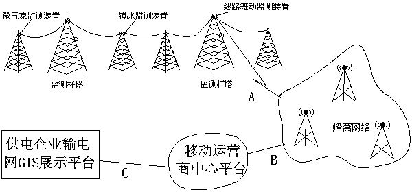
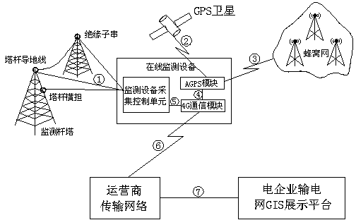
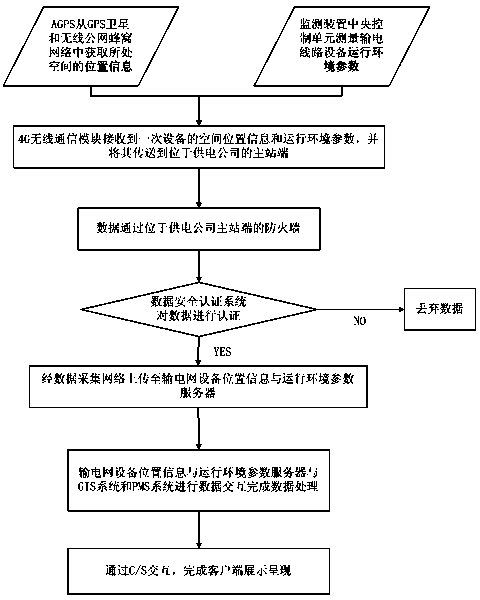
[0027] Such as figure 1 , figure 2 , image 3As shown, the transmission line GIS system and implementation method based on AGPS and 4G, the GIS system includes an online monitoring system, transmission network and GIS platform, the online monitoring system includes a monitoring device, AGPS module, 4G wireless communication module and information server, 4G wireless communication The module is connected to the monitoring device, AGPS module and information server through the Zigbee network. The transmission network includes wireless base station routing, public network data collection server and wireless public network platform; the information server includes the transmission network equipment location information server and the operating environment parameter server; the monitoring device includes Micro weather monitoring device, video monitoring device, icing on-line monitoring device, insulator leakage current on-line monitoring device, salt density on-line monitoring de...


PUM


Abstract

The invention discloses an electric transmission line GIS based on an AGPS and 4G and an implementation method. The electric transmission line GIS based on the AGPS and 4G comprises an on-line monitoring system, a transmission network and a GIS platform. The on-line monitoring system comprises a monitoring device, an AGPS module, a 4G wireless communication module and an information server. The 4G wireless communication module is connected the monitoring device, the AGPS module and the information server through a Zigbee network. The transmission network comprises a wireless base station router, a public network data collection server and a wireless public network platform. The information server comprises a transmission grid device position information server and an operating environment parameter server. The AGPS module is connected with a GPS satellite and a GPS secondary server. Through the application of the electric transmission line GIS based on the AGPS and 4G on the online monitoring devices of electric transmission lines, a great number of working processes of on-the-spot investigation and input by power supply operation and maintenance staff are avoided, the reliability and the timeliness of the parameter information of the environment where the electric transmission lines and devices are located, a power transmission network operation administrator can observe automatically updated coordinate data and operation environment state data of the transmission devices on the GIS platform.

Description

technical field [0001] The invention relates to the technical field of on-line monitoring and communication of power system transmission lines, in particular to an AGPS and 4G-based power transmission line GIS system and an implementation method. Background technique [0002] The power grid GIS system is to organically integrate the geographical location, production operation, operation management and other information of the equipment and facilities of the power grid enterprises in the links of power generation, transmission, transformation, distribution, and power consumption with basic geographic information such as two-dimensional / three-dimensional terrain, landforms, and features. A unified system for integrating and publishing presentations. In recent years, the power grid GIS has been widely used in the power system, and has played an important role in power production and management, providing users with reliable auxiliary decision-making means and basis. [0003] T...

Claims


Application Information

Patent Timeline
Patent Type & Authority Applications(China)
IPC IPC(8): H02J13/00G08C17/02
CPCY04S40/126Y02E60/00
Inventor 邱超张平狄立
Owner STATE GRID CORP OF CHINA
Why Eureka
Try Eureka