Automatic contour elevation value assignment method based on triangulation network

A contour line and triangulation technology, applied in the field of geographic information, can solve the problems of large amount of calculation and long time consumption, and achieve the effect of ensuring accuracy and improving calculation speed and efficiency

Active Publication Date: 2015-02-04
LUOYANG INST OF ELECTRO OPTICAL EQUIP OF AVIC
View PDF2 Cites 15 Cited by
  • Summary
  • Abstract
  • Description
  • Claims
  • Application Information

AI Technical Summary

Problems solved by technology

[0005] The purpose of the present invention is to provide a method for automatically assigning heights of contour lines based on triangulation, so as to solve the problems of large amount of calculation and long time consumption in existing elevation assignment methods

Method used


Image

  • Automatic contour elevation value assignment method based on triangulation network
  • Automatic contour elevation value assignment method based on triangulation network
  • Automatic contour elevation value assignment method based on triangulation network

Examples


Embodiment Construction

[0038] The specific embodiments of the present invention will be further described below in conjunction with the accompanying drawings.

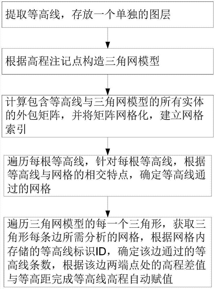
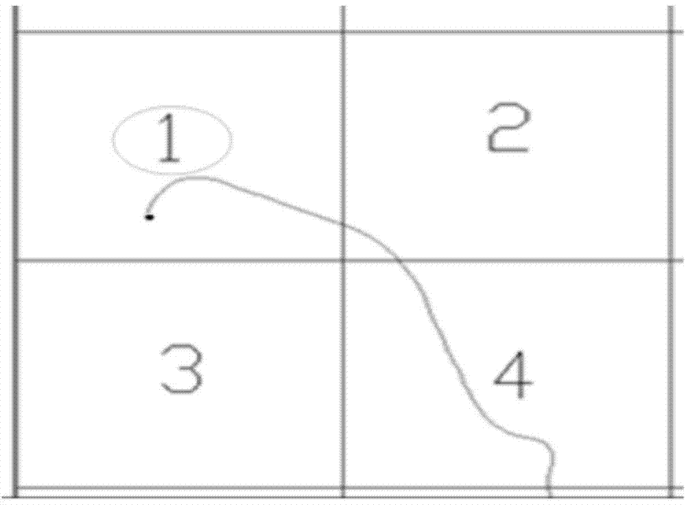
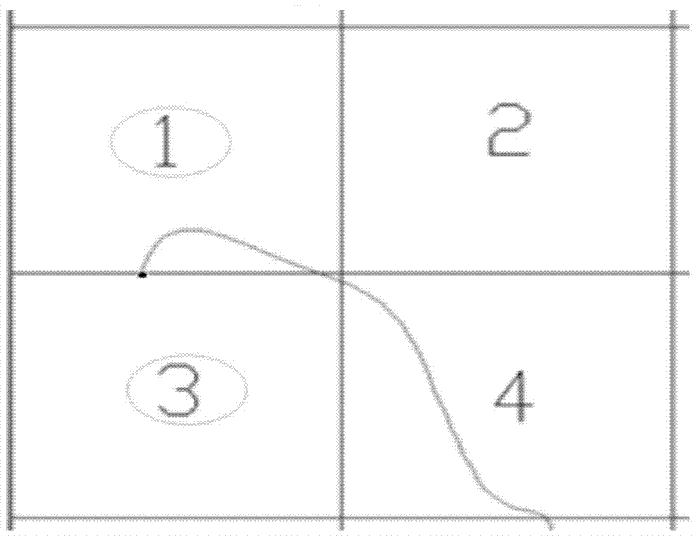
[0039] The invention provides a method for automatically assigning the elevation of a contour line based on a triangulation network. The method creates a grid index before intersecting a triangular network edge line and a contour line, and reduces the height of the contour line intersecting with a triangle edge line. The number of bars can significantly improve the calculation speed and efficiency while ensuring the accuracy. The process of this method is as follows figure 1 As shown, the specific process is as follows:

[0040] 1. Extract the contour lines from the original topographic map and store them in a separate layer.

[0041] 2. Construct a digital elevation model (terrain triangulation model) according to the elevation annotation points.

[0042] 3. Draw the grid, establish the grid index, calculate the outsourcing matrix includi...


PUM


Abstract

The invention relates to an automatic contour elevation value assignment method based on a triangulation network and belongs to the technical field of geographic information. The automatic contour elevation value assignment method comprises the steps of establishing an outsourcing matrix according to a triangulation network model established by use of contour lines and elevation points with notes, dividing the outsourcing matrix into grids, traversing each contour line, for each contour line, determining the grids through which the contour line passes according to the intersection characteristics of the contour lines and the grids, traversing each triangle of the triangulation network model, obtaining the grids needing to be analyzed at each edge of the triangle, determining the number of the contour lines through which the edge of the triangle passes according to the contour line identifiers ID stored in the grids, and then performing automatic contour elevation value assignment according to the elevation difference value and the contour interval between the two endpoints of the edge. The automatic contour elevation value assignment method based on the triangulation network has the advantages that a grid index is created before the intersection of the side lines of the triangulation network and the contour lines, and therefore, the number of the contour lines intersecting with the side lines of the triangles is reduced, and consequently, the computation speed efficiency can be remarkably improved while the accuracy is guaranteed. Meanwhile, the method is capable of capable of discovering whether the contour lines are wrong.

Description

technical field [0001] The invention relates to a method for automatically assigning the height of a contour line based on a triangulation network, and belongs to the technical field of geographic information. Background technique [0002] In the digital map, there are often cases where the contour line has no elevation value or the elevation value is wrong, which greatly affects the accuracy of the later terrain processing and site leveling. With the increasing application range of digital maps, it is very common to realize multiple applications by reading the elevation value of contour lines. Therefore, a method that can assign values ​​to contour lines and correct errors is needed. [0003] In the existing technology, the automatic assignment of contour elevations is mainly carried out through manual entry and batch labeling, while the traditional manual manual labeling one by one or batch labeling requires more manual intervention, and is time-consuming and labor-intensi...

Claims


Application Information

Patent Timeline
Patent Type & Authority Applications(China)
IPC IPC(8): G06T17/05
CPCG06T17/05G06T17/30
Inventor 王丽君高成志张锦赓刘中海
Owner LUOYANG INST OF ELECTRO OPTICAL EQUIP OF AVIC
Why Eureka
Try Eureka