A peat swamp information extraction method based on envisat ASAR, Landsat TM and DEM data
A technology of information extraction and data, which is applied in the directions of instruments, character and pattern recognition, scene recognition, etc., can solve problems such as the difficulty in distinguishing peat bogs from other types of swamps, and achieve the effect of overcoming omission and misclassification
- Summary
- Abstract
- Description
- Claims
- Application Information
AI Technical Summary
Problems solved by technology
Method used
Image
Examples
specific Embodiment approach 1
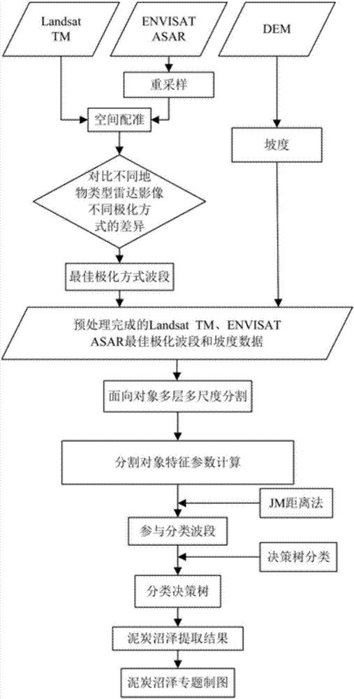
[0028] Embodiment 1: A peat swamp information extraction method based on ENVISAT ASAR, Landsat TM and DEM data in this embodiment is specifically prepared according to the following steps:
[0029] Step 1: Preprocessing the Landsat TM data;
[0030] Step 2: Preprocessing the ENVISAT ASAR data;
[0031] Step 3: Resample the ENVISAT ASAR data preprocessed in Step 2 in ArcGIS. The resampled ENVISAT ASAR data has the same grid size as the Landsat TM data processed in Step 1;
[0032] Step 4: Based on the preprocessed Landsat TM data, compare the preprocessed Landsat TM data and the resampled ENVISAT ASAR data in the ArcGIS software, and use the function of adding control points provided by the Georeferencing module of the ArcGIS software Select the control points on the preprocessed Landsat TM data, and register the resampled ENVISAT ASAR data according to the control point space to obtain the ENVISAT ASAR image;
[0033] Step 5: Use the Aspect command in Surface Analysis under ...
specific Embodiment approach 2
[0046] Specific implementation mode two: the difference between this implementation mode and specific implementation mode one is: in step one, LandsatTM data is carried out to the preprocessing process as follows:
[0047] (1) Within the distribution range of the peat bog, determine the track number of the Landsat TM data of the peat bog, and download the Landsat TM data covering the distribution range of the peat bog according to the track number;
[0048] (2) In order to eliminate terrain distortion, the Landsat TM data is orthorectified by using the DEM data of the corresponding area of the Landsat TM data to obtain the Landsat TM data after orthorectification;
[0049] (3) In order to eliminate geometric distortion, use terrain data, select ground control points in ERDAS software, and perform geometric fine correction on Landsat TM data after orthorectification to obtain preprocessed Landsat TM data. Other steps and parameters are the same as those in Embodiment 1.
specific Embodiment approach 3
[0050] Specific implementation mode three: the difference between this implementation mode and specific implementation mode one or two is: in step 2, ENVISAT ASAR data is carried out preprocessing process:
[0051] (1) Within the coverage of the Landsat TM data range, download the ENVISAT ASAR fine image first-level data (ENVISAT ASAR APP Level 1B data) used in the test (the polarization mode is HH and HV);
[0052] (2) Carry out radiometric calibration on ENVISAT ASAR fine image first-level data, that is, convert the DN value of ENVISAT ASAR fine image first-level data into backscatter coefficient (in dB), and obtain radiometrically corrected ENVISAT ASAR data; its radiometric calibration The formula is as follows:
[0053]
[0054] in, is the backscatter coefficient of the pixel in row i and column j; DN ij is the original intensity value of the pixel in row i and column j; θ ij is the radar wave incidence angle of the i-th row and j-th column pixel; K is the absolute...
PUM
 Abstract
Description
Claims
Application Information
 - R&D
- Intellectual Property
- Life Sciences
- Materials
- Tech Scout
- Unparalleled Data Quality
- Higher Quality Content
- 60% Fewer Hallucinations
Browse by: Latest US Patents, China's latest patents, Technical Efficacy Thesaurus, Application Domain, Technology Topic, Popular Technical Reports.
© 2025 PatSnap. All rights reserved.Legal|Privacy policy|Modern Slavery Act Transparency Statement|Sitemap|About US| Contact US: help@patsnap.com


